At 5pm, to the station at Cromford. I took train through to Derby through the sunny late afternoon. At Derby I adjusted the straps of my new rucksack to what I hoped would be a satisfactory arrangement. I bought a bottle of London Pride from a shop across the road from the station. Through to London in first class, a most pleasant experience for which I paid about £30. I could have picked up the sleeper at Crewe: I have done this before. But then it would have been necessary to wait on Crewe station for nearly two hours til almost midnight. Even on a warm summer evening, that’s not a sensible way to spend time. I walked the few hundred yards through to Euston station, walking behind the British Library, before joining the Caledonian sleeper a little after 8.30p.m. I ordered a full breakfast for £10- life is too short!
I slept fitfully, as I generally do on the sleeper train, but I know I did sleep, for I dreamed. I recommend the use of the Caledonian sleeper. If you can stand the narrow bed and cramped conditions, it is in my view, a cost-effective way to travel to Scotland. I got off at Dalwhinnie, after my full breakfast, into thick, grey morning mist. The train rumbled off towards Inverness, its red taillight disappearing into the mist. All was quiet. The time was 0655. One man got off ahead of me and walked away ahead of me.
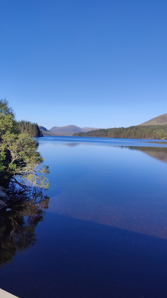
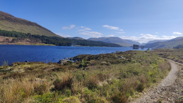
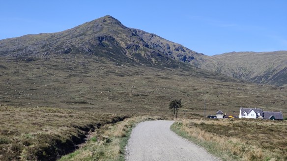
I started off on the long walk-in, which begins with a detour along the main road as a key level crossing is closed. It is a long and tedious walk-in along a good and reasonably flat unmade road on the west bank of the reservoir, the enormous Loch Ericht, a loch so long that I could see the horizon at the other end of it. From Dalwhinnie station to Ben Alder Lodge, where the route leaves the road, about 12km. I was consciously and deliberately trying to keep my pace down, albeit with only limited success. I’ve seen and experienced in the past, the effects of walking too fast, too soon. But the slowest I could manage along the flat was about 13 minutes per kilometre. After Ben Alder Lodge the path trends to the right and uphill, through woods onto the open moor. At this point I found myself ahead of the gentleman I’d followed along the lake shore. The path arrows up into the brown hills; it was so very, very dry. Every small stream I crossed was dry; every drain and ditch, just full of dust. I wondered if there was any water at all in these hills. I was glad to arrive at a big stream, which ran clear and fresh, though somewhat depleted. The stream led up to Culra.
I arrived there at around 11a.m, as I’d predicted when planning this trip as a desktop exercise during the winter months. 17km in four hours. At Culra there is Culra Lodge (a wooden hunting lodge, locked down, with a wind turbine), a bothy (closed due to asbestos), and about half a dozen tents pitched. I added my own tent and sat outside for a leisurely lunch. The older man I’d seen earlier, who I’d burned off on the climb up to Culra, arrived and we had a brief chat. His destination, as was mine, was Corrour.
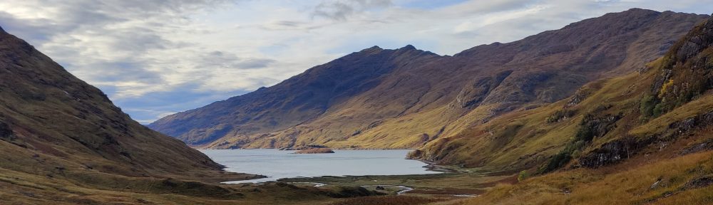
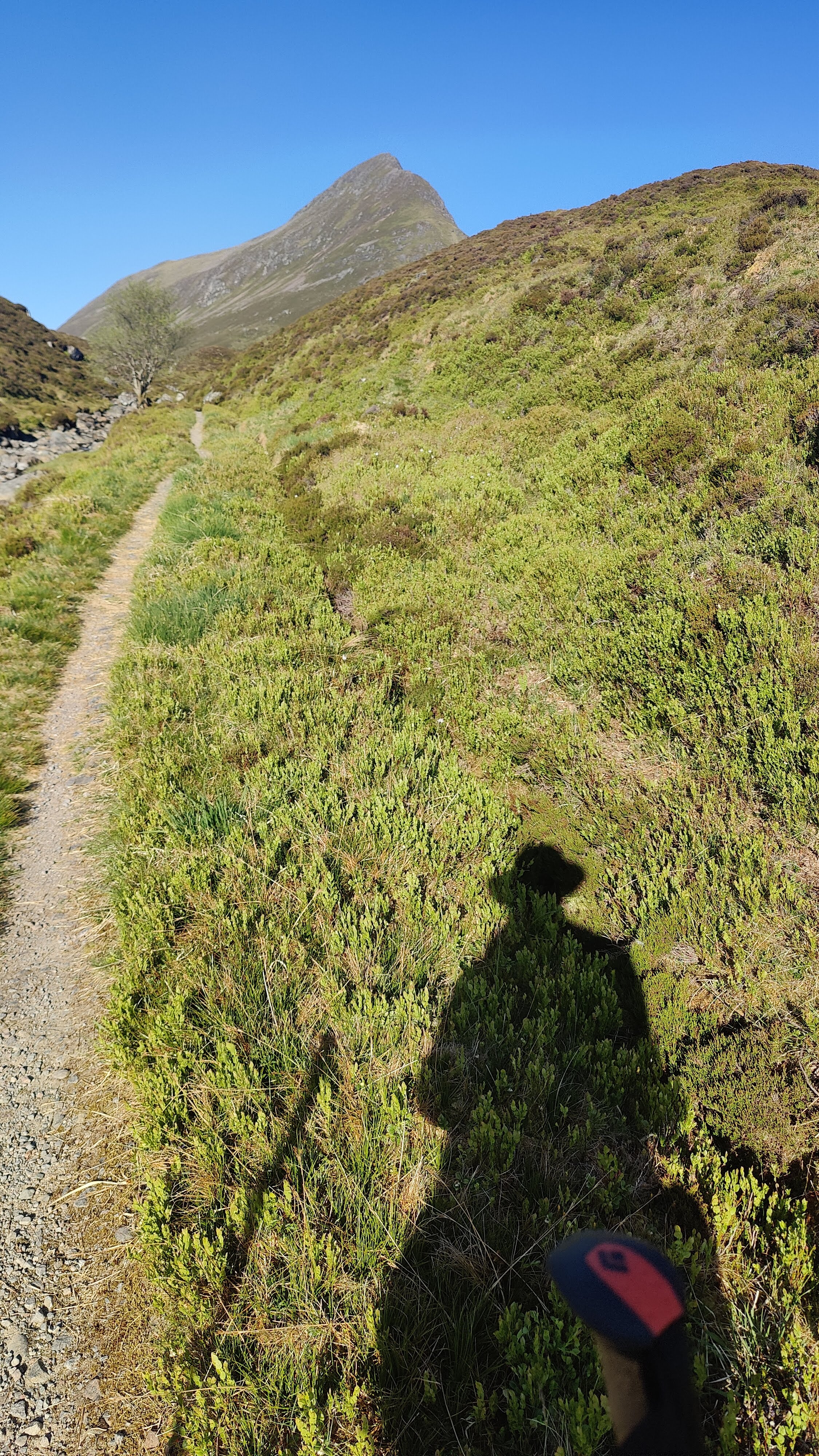
After lunch I pulled together what kit I needed for hillwalking and stuffed it into my now almost empty rucksack. What did I carry? Sunglasses, sunhat, warm jacket, spare long trousers (I was in shorts), first aid kit, food and water, map and compass, walking poles. What did I leave behind? Tent, stove, fuel, sleeping bag and mat, more food, my Kindle and notebook and power banks. After judicious use of suntan lotion, I set off over the brown moor, under a cloudless sky. Up and over the moor, as dry as any I have ever seen, rising into a small glen containing not a high mountain tarn, but a substantial ribbon lake, Loch a Blealaich Bailthe. The atmosphere was magical as the path led round the lake, with the massif of Ben Alder on the far side. I met a young man and woman, mountain cyclists who had cycled over Ben Alder. This hill is so remote that to climb it in a single day trip without the use of a mountain bike is quite tricky, even in summer. Not long after that I stopped for a while for a second lunch and bathe my feet in the loch. To wash your feet in such water as this, on such a day as this, is to wash away tiredness and pain, to sooth away discomfort and ache.
I continued up to the col – Bealach Breabag – and then on upwards to the right under hot sunshine. It was sleep but perfectly manageable. As I climbed, I encountered a party of five older men coming down, so I knew I was on the right track. Straightforward enough, in this weather, to continue upwards and onwards to the summit of Ben Alder, a most remote mountain.
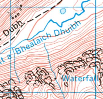
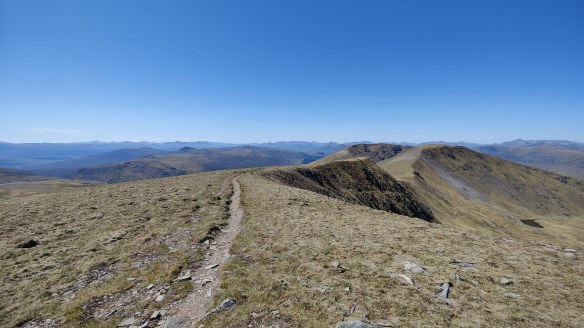
Not long after point 1081, I made a grave mistake. Treading north in the afternoon sunshine, I could see the sharp ridge of the Short Leachas ahead of me. There was no descent possible this side of it; the Harvey’s maps (1:40k and 1:25k) I had on me did not reveal a usable descent on the other side of it. Yet, descent there must be – to this day I do not know where. Possibly it goes directly down the Long Leachas ridge. I opted instead to swing to the left and downhill, aiming for the valley of a stream unnamed on the Harvey’s map, along which no cliffs were marked. There being no signal, my phone would not resolve to the 1:25k OS map, so all I had was the 1:50k which showed this. After the fact, a close reading of even this low scale map does reveal that this is a hanging valley and that therefore there are likely to be cliffs. I should have known better. The sun was bright, the phone screen was hard to see, and I didn’t see what I ought to have seen. To say nothing of the word ”waterfall” which was warning enough!

I descended on the right, keeping in the sunshine, until I could go no further as cliffs impeded further downhill progress. I put away my trail poles as doing more harm than good in a very steep and rocky place. Then I crossed over to the left-hand side, taking the opportunity to drink from the stream, and continued downhill again before my path was blocked by gently sloping slabs as the hanging valley opened onto the main valley. I was almost down and safe – but not quite. With great care and considerable difficulty, I made my way back to the stream, descending all the while, and crossed over again. Most of the time I was descending sat down, but twice on that return to the stream I had to resort to descending face-in, and down-climb. I do not think I could have gone back up: whatever I was doing, at this late stage I was committed to going all the way down. I should have turned back earlier, but I didn’t. As I scrambled out of the gorge on the right bank again, I saw a huge deer run down to the water and disappear behind a fold of the land. It emerged seconds later barely yards from me, belting down the hillside in a panic of fear. I shudder to think of my fate had it collided with me.
In all of this descent I was never actually frightened; I was well aware that I could ill-afford to allow vertigo, or fear of getting stuck, to get the upper hand. That said, my pulse was up to 156 and I don’t think that was down to exertion, as I was going downhill. I was lucky with the weather, and I was lucky with the time of year – whatever I did, I had plenty of time. I had food, water and probably 4 hours of useful daylight to play with. From where I’m stood now I got out of that situation not only by luck, fitness and mountaincraft, but by the sheer grace of God.
In due course, therefore, through great care in route selection and discerning choice of foot placement, I made that perilous descent successfully and safely and found myself on the valley floor. There followed a 3-4km tramp through the mid-afternoon sunshine, down the valley to my tent at Culra.
My supper was taken outside my tent, sat by the stream in the warm sunny evening. I started with that Englishman’s staple, a Nice Hot Cup of Tea. After a break I followed that with fresh tortellini with an admixture of fried chorizo sausage, washed down by some red wine, and followed by hot chocolate. It was a warm night, and very tired, I slept like a top, turning in not long after 2130.
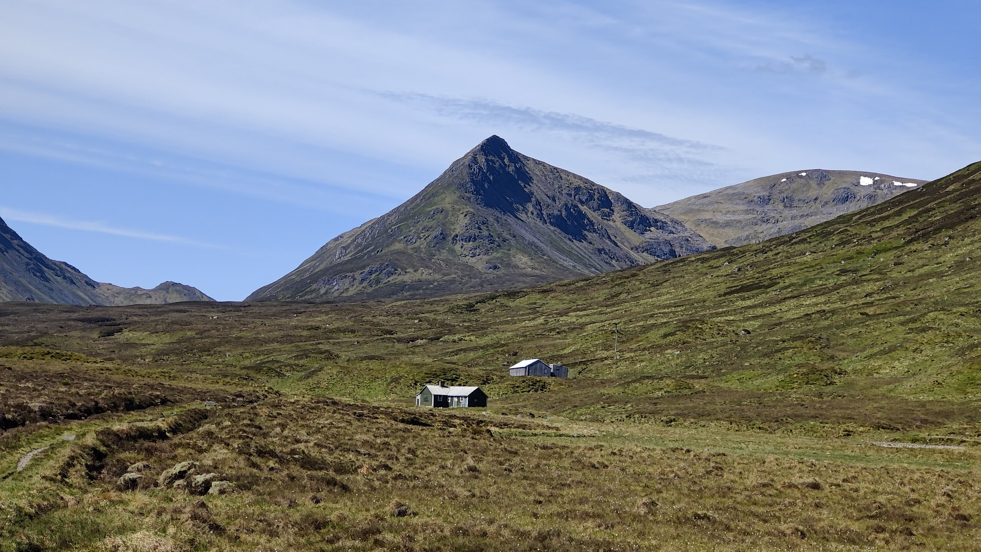
I was away by 0700 the next morning. I have divided my tent up into three separate dry bags. This makes it easier to pack and easier to keep important parts of it dry. The inner tent, the flysheet, and the groundsheet and pegs are all in separate bags. That was unnecessary this morning after a completely dry strike – there was not a hint of dew. My path led back up the same route I had came down the previous afternoon, but as the Bible and the well-known hymn remind us, “morning by morning new mercies I see” – this morning, with the sun from a different direction, this was a different place, an absolute paradise. A stream wandered down the brown valley, babbling past rowan trees and chuckling to itself as it ran over boulders. Glad I was indeed, to be permitted to be in such a place as this, on such a bright morn. I passed the scene of my adventure the previous afternoon, appearing this morning as grievous shadowed slash on the hillside, and continued upwards to the Bealach Dubh – black pass. I was entirely alone, at this early hour.
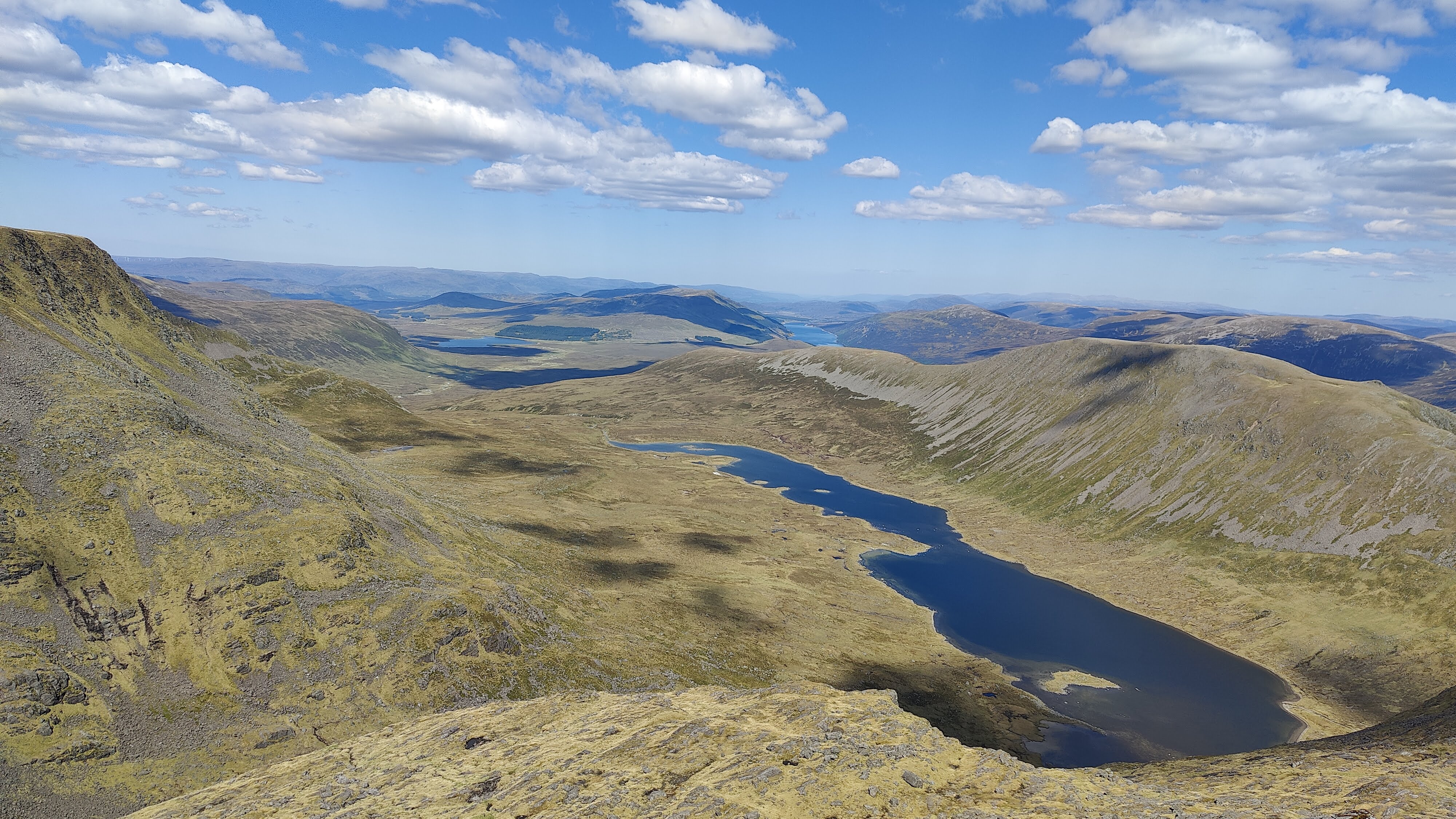
Carrying only a litre of water, augmented in my pack-up by several small oranges and a bag of small tomatoes, I set off up the hillside from the Bealach, conscious that I might not see running water again til late afternoon. There was no cloud in the sky; it was barely 0900. Not far up the hillside I did in fact find the very tiniest little streamlet, a mere dribble running clear and cold. Not something one would normally touch, and certainly never in the Lake District with its ubiquitous livestock. I filled my spare water bottle – another litre – added a purifying tab and marked the bottle so I knew which of the two bottles was which. In the end, I never needed it. It was just there in case. My path led up a shoulder of green grass and grey stones, never steep enough to climb with feet and hands, but rocky enough to make trail poles a liability at times. Geal Charn (1132m) was a dun hill, a huge, rounded plateau, a rolling summit of brown grass. As with some of the landscapes on Ben Macdui, it is reminiscent of parts of the Dark Peak – but this is 1100m above sea level. It’s NOT the Dark Peak. From Geal Charn, easy and gentle hillwalking continues, up and down, over Aonach Beag (1116m) and Beinn Eibheinn (1102m). I rather suspect that the ups and downs I found easy, even carrying nearly 20kg, because I’m very fit. There were no clouds, little wind, and no shelter from the sun. In these conditions, a sun hat and sunglasses are PPE, not an optional extra. I met around ten people at various points on this hike, all going in the opposite direction to me.
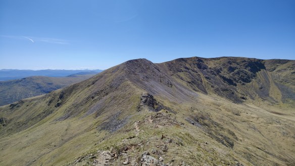
From Beinn Eibheinn, down to Meall Glas Choire, crossing a rather strange dry gap at 730436. As someone trained in geology I wondered at its formation. It resembled the Chalamain Gap in the Cairngorms, though on a much less grand scale. It is a strange thing to see, at such a high altitude, boulders rounded by some primordial torrent, in what was clearly a dry riverbed. I suspect that at some point at the end of the ice age, the retreat of a glacier has caused some temporary glacial lake to burst its banks, and a torrent like unto Niagara, has carved through this hillside. This kind of thing happens in the Himalaya even today.
Onwards down the brown grass to a rocky knoll, Creagan na Craibhe, and thence down through troublesome and difficult heather to the stream. This trackless ground was bone-dry and in a normal May would have been difficult, squelchy terrain. The stream was actually a substantial river and was called Uisge Labhair – “the waters spoke” or such. See that Gaelic word “Uisge”? After you try pronouncing it, it will become more familiar.
And there I stayed, dear reader. I washed my feet in the waters of that noble river, and made my camp nearby, near the place on the map called Lub Mholach. This was the finest camp I have made in many a long year. It was a magical garden spot. I bathed in the river, dried off and had my supper. Red Lentil Dhal, Farinata, Red wine. Though there was no mountain to the west like last night, to provide shelter from the evening sunshine, I was tired enough and retreated to my sleeping bag around 2100, before the sun had even set. I was very cold that night. I had wondered before the trip if I should invest in a lighter weight summer sleeping bag, but my experiences this night, tell me to stick with the three-season down bag and silk liner even in a warm Scottish May
Next morning I was awake bright and early and out of bed and breakfasting before 0600. A breakfast of champions: porridge (with Grouse and chocolate in it), black coffee with sugar, and fried bread and fried chorizo with melted cheese. My feet, which had been sore in the late afternoon, felt a little better after a night’s rest and some Paracetamol. I packed up and was away before 0700, to hike something like 10km through to Corrour station, arriving there just after 0900.
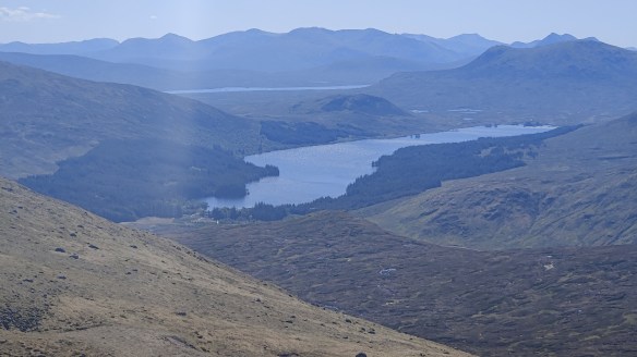
A delightful hike through the woods along the shores of Loch Ossian. Arriving at Corrour station, in the brown emptiness, under the endless blue sky, I was dismayed to find the cafe shut, but that couldn’t be helped. I had enough food left to make a cup of hot chocolate, and a cheese and egg sandwich, whilst I waited, in company with others, for the train.
By train two hours down the line to Arrochar and Tarbet. I had a “credit” for an unused night in the Tarbet Hotel on Loch Lomondside, and I made use of it to stay here tonight. Once checked in, I enjoyed several cups of tea and a long shower, before descending to the bar without boots on, to sit and enjoy a pint and a pub supper after another successful hiking adventure.
The next day, I took train from Arrochar and Tarbet to Glasgow Queen Street. I walked the few hundred yards to Central Station and took a Pendelino to Preston, then another one to Crewe. I had a “Standard Premium” ticket which was effectively first class without the catering. I thought it was good value at £130 for a four-hour train ride. At Crewe, a seamless change into a smaller and less salubrious train bound for Newark, which encountered technical problems – the first problems on this complex return train journey – which meant that I missed my connection at Derby. Hey-ho – I got home an hour later. Sat in the train at Blythe Bridge, waiting for the fault to be found, I remember a similar experience as a boy in the early 1970’s on our way back from Blackpool, when a Crewe-Newark train we were in broke down somewhere along there. On that occasion we had to wait a lot longer than an hour. The trains? Cromford to Derby (£8), Derby to London in first class (£32), London to Dalwhinnie in the sleeper (£255), Corrour-Glasgow (£35), Glasgow to Crewe in standard premium, (£133), and Crewe to Cromford (£20). The journey I made could not have been easily accomplished at all without public transport, and I deemed it good value for money.
Geek stuff – gram counting and costs
My rucksack, an Osprey Aether Pro 75, weighed around 14.5kg without food and water. The Aether Pro 75 is probably the lightest serious expedition rucksack on the market in the UK, weighing a truly astonishing 2.1kg empty. Here’s a table of the weight of some of my kit:
| Kit item | Rucsac weight |
| MSR Elixir 2 tent and pegs stored in dry bags, poles | 2805 |
| Aether Pro 75 rucksack | 2100 |
| Skyehigh 700 sleeping bag with compression drybag, cotton bag and silk liner in its bag | 1300 |
| Trangia 27 with matches, striker etc | 840 |
| Lhotse raincoat | 580 |
| Spare clothes (socks, underwear, T-shirt) | 550 |
| First aid kit | 460 |
| Trangia fuel (ethanol) with bottle | 412 |
| Thermarest mat | 380 |
| Mountaineering trousers | 365 |
| Notebook with pens | 260 |
| Goretex overtrousers | 238 |
| Goretex gaiters | 231 |
| Merino wool leggings (winter only) | 200 |
| Kindle | 187 |
| 2 x Powerbanks | 362 |
| Merino wool hat | 175 |
| plate, cup and spork | 170 |
| sun hat | 133 |
| Black Diamond headtorch w/batteries | 120 |
| Mittens winter only | 120 |
| Garmin Inreach Mini 2 with karabiner | 114 |
| Thick gloves | 107 |
| Aftermarket rain hood for rucsac | 104 |
| Ledlenser lantern with cable and battery (winter only) | 91 |
| Maps | 85 |
| Sh1t shovel | 83 |
| Spare drybag | 70 |
| 2 x lightweight (not climbing) karabiners | 50 |
| USB-C charging cable | 50 |
