18/2/84 Ben Nevis
Route: Ben Nevis from the youth hostel. 8 hrs, 6 miles
This was the time when we had a puncture at coming along the main road at Ballachulish, very late in the evening. I can’t swear it was before midnight – in those days it was a long drive from Sunderland, and we had not left Sunderland until around 5pm. We’d take the A68 straight through the interior, rather than the (then, as now I suspect) much slower and longer route up the coast on the A1. The road led over Carter Bar and through Jedburgh. Again, in those days there was no Edinburgh bypass, and we had to go right into the heart of Edinburgh, right to Haymarket, where we sometimes stop for chips. I remember piling into a chippy near Haymarket, 15 English students, and the atmosphere in that chippy going distinctly frosty. You’d think they’d be happy for the custom of 15 hungry students: obviously not. I confess I’ve taken a dim view of Scots nationalism ever since. But I digress.
The minibus ground to a halt and we laboured to get the spare out, get all the gear out and get the bus on jacks to change the wheel. We never needed to get the jack out. This was because the spare tyre was flat. “This is best yet” (as in best cock-up) Alister confided to me. He was in his second year and more experienced with the mountaineering club. Someone went to the nearest phone – itself miles away – and called for help, which I seem to recall was hours coming. Suffice it to say it was the back end of the small hours before we all so much as unpacked a sleeping bag at the Tin Shack Hut in Glen Nevis.
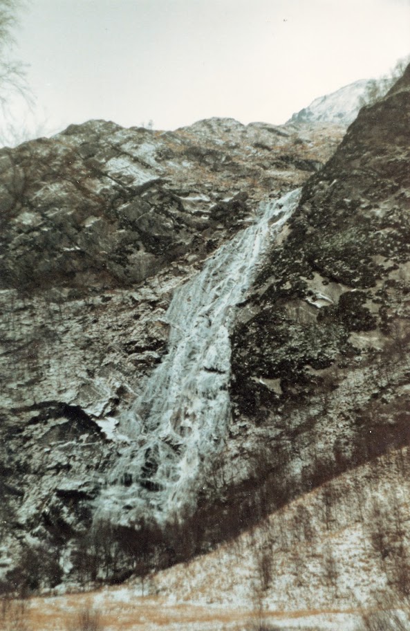
Next morning, a fine early start for a party of six including Tim, Alister and myself, led by “Climbing Nigel”, a very opiniated but able Outdoor Ed student from South Shields. We went up the tourist path with Matt Harding and J.T headed for an ice-climb on Nevis. Breathless at Halfway Lochan. We met some American B.Ed students, from Colorado, at the lochan. Some way above the lochan we met the first snowfields and stopped to practice ice-ace braking for a while. Then we moved on up interminable deep and thick snowfields around 35 degrees steep. We put on crampons to move up a particularly steep slope of very hard snow. The wind whipped our clothing; the mist closed in causing temporary whiteout. Eventually the slope evened out and we crossed to the summit in a screeching gale. The mist cleared every so often to reveal stunning vistas. Above 4000’ the ice formations – frost crystals – on this highest of British summits, I found fantastic to look at. The rocks not completely covered in snow were completely iced over with opaque pointed crystals, each aligned with the prevailing wind direction. The ruins of the observatory on the summit were almost completely buried, indicating metres of snow cover. Such stonework as was visible was iced over, covered in inches, no, feet, of frost crystals.
It was, to quote W.H Murray, “a strong shouting day, but harmless”. The gale was too strong for us to remain on the summit for long, so we quickly got off the top and out of the wind. As we did so, the weather improved; clouds disappeared from the summit, which remained clear as we moved downwards.
We descended a steep snow-filled gully, doubtless a stream bed in summer. We tried glissading but the snow was too soft. As the gully steepened, we found we needed to avoid the footprints of others, where the snow had frozen very hard. Some way down, Tim slipped, lost his axe and went sliding downwards. He zapped past Nigel and I. Nigel cried out, “spread out, lie flat” – the injunction being to make your contact area with the snow (and hence friction) as large as possible. Tim stopped after a few hundred feet and was uninjured save for a cut to his knee. He retrieved his axe and we moved on. We stopped to chat with some Scotsmen who had not made it to the summit. They had seen Tim slipping. We spoke of the distance the English need to drive in order to get onto the hill in the Highlands, and their subsequent desire to get on the hill no matter what. This, the Scotsman opined, was the cause of “nearly all the accidents” on the Scottish mountains.
The gully brought us back to the first snowfield where we had originally practiced. Here we rested before continuing down to the Halfway Lochan. On the tourist path, Nigel found an abandoned or lost pair of Dachstein mittens.
Conditions on high looked superb, and we were of the opinion that we had come down too soon. “We should be up there now, not down here” Nigel said. We finished at 4p.m. We were on the hill for around 8 hours. 8600’ covered in the vertical, and around four and a half hours to the summit.
19/2/84 Benighted in the Mamores
Route: Am Bodach and the Mamores including an unplanned overnight bivvi
The same party as yesterday set off from the tin shack hut in Glen Nevis, about nine o’clock. We headed up a valley which my notes call “a tributary valley” leading to the main ridge of the Mamores. Someway up the valley, one of us turned back. The rest of us continued until we got to the edge of the first snowfield. At that point – this was the right and useful influence of the Outdoor Ed students – all stopped for a thorough session practicing ice-axe braking.
Onward over hard frozen snow. To our right, Stob Ban soared – grey rock and white snow against the blue sky. Against a fierce wind, we arrived at the lip of the corrie and saw the summit ridge. The corrie was a metre or deeper in snow. We sheltered from the howling wind in a snow cave built by some other mountaineers. On the corrie floor, were the remains of an igloo.
After lunch we continued, refreshed, but nonetheless into the teeth of the gale, up onto the ridge. Absolutely magnificent scenery – I had never seen anything like it. Mountain after mountain was stacked up on the right, off to the horizon, whilst behind us, the rest of the ridge arced away. Still in the company of the shrieking wind, we climbed up to the summit in bright sunshine, under blue skies. Over the summit, down the other side, an enormous and steep descent, corniced on the left. On the right, a corrie filled with snow, no single rock in sight. I found the descent hair-raising but would not have missed it for the world. We came to a col; on the left, far below, was another tributary valley of Glen Nevis. It was a hanging valley: it did not at that point cross our minds that the cliff over which the stream descended into Glen Nevis, might prove impassable. It was 3pm.
We moved onto the next peak in the ridge, Am Bhodach. Breathless on the top, we spoke briefly with another party there. We gazed down the ridge; a party were slowly hacking their way up to the summit. We ourselves moved onto the very steep valley side, and carefully, our more experienced colleagues cut steps downward. [22/1/21 At getting on for 40 years remove am not sure why this was necessary when we all must have had crampons and were familiar with their use. It must have been very steep and very hard snow.] A little way along, Nigel thought we’d be better turning back; he climbed back to the ridge, cut through the cornice, and prepared to belay us all back onto the ridge. There was a disagreement; the party felt that this was not the way to go; we continued downwards slowly, two or three times on a rope, through a lot of cut steps, until the slope slackened to the extent that we could glissade harmlessly to the valley floor. Unfortunately, it was now dark.
We hurried along the valley, singing. When the darkness was quite complete, the valley became a gorge. The path became very tricky, frequently covered in frozen puddles which were lethal in torchlight. The thunder of the falls came to our ears as a death knell, as it were. There may be a way down from above the Steall Falls but we were not going to be successful in finding it in darkness. It just fell away from us in distant tantalising shapes. It was very much with the taste of defeat in our mouths, that we conceded the need to bivouac. It was Sunday night. We were very much aware of the trouble this would cause.
Apart from a change of bivvi site during the night, the bivvi was harmless. I spent quite some time with my feet and legs in my rucsac to keep them warm. We were away, shivering like leaves, at 7am. In the grey light of dawn we backtracked, crossed into the next valley, and descended into Glen Nevis to meet our fate.
16/4/84 Eastern edges of the Peak District
Route: The Oread Hut (“Heathy Lea”, Birchens and Baslow Edges, Wellington Monument, Baslow/Curbar/Frogatt edge to Grindleford Café, back along the river to Hathersage and back to Baslow
Rich and I took an early start from Heathy Lea, up to the Robin Hood, thence wandering under Birchens edge and then up onto Gardoms. This well-trod route brought us out onto the A621, and thence on the path up to the Wellington Monument, where a long discussion about music began. Baslow, Curbar and Froggatt Edges passed as we comfortably moved along. Leaving the edges, we consulted the map for the first time, and consequent to that, descended to Grindleford Café for a pint of tea. Here it was that a “Cafes of Derbyshire (deliberately following the popular “caves of Derbyshire”) was mooted. The next step would be Eric’s in Stoney Middleton, followed by the café in Eyam…
It was not to be, however. I needed some cash, so we hotfooted along a pleasant riverside path into Hathersage, and had a pint in the “Little John”. I tried to get cash from Williams and Glyns Bank, and eventually succeeded in obtaining some in the NatWest [this was long before cashpoint machine ubiquity.]
We returned south more slowly, along the road. My feet were hurting. Robin Sedgewick [one of our teachers, Oread MC member and one of the organisers of this weekend] passed us, and several lorries ran very close to us. We returned to the OMC hut through the forest and directly over the fence opposite the hut, rather than following the path.
22/7/84 Coniston Old Man from Dunnerdale
Route: From the Leeds University mountaineering club hut at Dale Head in the Duddon valley, up Grey Friar, Swirl How, Coniston Old Man, Dow Crag, Brown Pike and back to the Leeds hut. 12 miles, 7 hours. Alone.
A huge assault on Grey Friar straight from the Leeds Hut brought me to the summit, drenched in perspiration, after 54 minutes. The weather, as on this hike one year previously (the hike that opens this account) improved as I moved round to Swirl How. I passed a cross and the remains of the undercarriage of a WWII fighter aircraft. Looking back I could see people in Grey Friar; I moved on. Both Coniston Water and Windermere were visible, though photography was out – too hazy. I stayed the pangs on Brim Fell with a cup of tea and a Mars bar [10/1/21 did I take a flask in summer?] Noon saw me on the summit of the Old Man, which was crowded with both people and biting insects. “Bobby” G, and Laurie, and Matt arrived on the summit some ten minutes after me, followed shortly by J. Rivett and Claire G. [All of these people in the sixth form in my year or the years above or below me.]
We all remained on the summit for a while before Bobby G and Laurie set off to do a route on Dow Crag. Rivett, Matt, Claire G and I followed at a leisurely pace to Dow Crag. [10/1/21 I remember this walk for a snippet of conversation, Rivett saying to Claire “…and that’s why you’re doing Combined Studies at Mickleover” (Mickleover being one of the campuses that became the University of Derby years later)]. At Dow I found myself alone again as those three trod the path for Seathwaite Tarn, whilst I stayed on the ridge down to the Walna Scar pass.
Very slowly, for there was no hurry, I dropped down into the Duddon valley, enjoying some pleasant navigation work across the valley floor farmland. I passed Birks Bridge and found Rivett and Matt swimming in the pools there, so I joined them for a refreshing swim at the end of a rather enjoyable day.
23/7/84 To Three Tarns from Dunnerdale
Route: From the Leeds University mountaineering club hut at Dale Head in the Duddon valley, up to Cockley Beck Farm (the junction with the Wrynose road) then up Red Howf/Little Stand, onto Adam-a-cove, Crinkle Crags, Shelter Crag, Three Tarns, down Lingcomb Beck to Mosedale, then Yew Bank, Hard Knott, and back to the Leeds hut. 13km 8 hrs. Alone.
In shorts and cut-offs, I proceeded under clear blue skies to the Red Howff. There was no path to this summit. I went straight up through gulleys, bracken and rocky bits. It was a wet, boggy summit. From here, a short walk to Adam-a-cove, one of my most visited tops. Butties here, before moving on. I felt just a twinge in my heels as I passed the next crags. At Three Tarns, I decided, rather than pressing on up Bow Fell, to drop down into the valley of Lingcomb Beck.
It was a long, hard and hot descent. Three Tarns disappeared and I found myself in a huge green amphitheatre. The sun was without mercy. I continued downwards and had a very refreshing swim at a small hole in the riverbed. The valley was deserted.
I moved along the valley and then up to the head of Mosedale. The entire horseshoe of mountain ridge was visible behind me – a splendid view, if spoilt slightly by the hazy summer atmosphere. I thought I’d end the day on a top with a truly magnificent view, so I moved onto the summit of Hard Knott, above the pass of the same name. On a clear winter’s day the view from here would be worthy of a 360 degree panorama.
I dropped off this top into the valley well satisfied, realising that the most famous hills and the highest tops don’t necessarily offer the greatest reward. W. H Murray, a hero of mine, said that the mountains “reward those who turn aside from commonsense routine”.
24/7/84 Scafell Horseshoe
Route: Scafell Horseshoe: Three Shires Stone – Adam-a-cove – Crinkle Crag – Shelter Crag – Bow Fell – Ore Gap – Esk Pike – Esk Hause – Broad Crag – Scafell Pike – Mickledore – the Lords Rake – Scafell – Slight Side – Quarigg Moss – Eskdale (the Woolpack). 14 miles, 8.5 hours
Four of us, along with Ian H and his six-year old son John, were given a lift to the top of Wrynose by RS. It was a bright blue morning – shades weather – but somewhat hazy. I was fit; this was the third day of walking. I led at what I considered to be a restrained and controlled pace, and Chris and Claire kept up, although they said afterwards that the first mile was done at a “ferocious pace”. Ian and his son John were left far behind, and the long haul up to Adam-a-cove opened up the usual scenic splendour. Eventually I stretched myself a little and burned up onto the summit, where some preventative first aid was required for my feet which were getting tender after three days hard hill-walking.
Ian arrived, gasping for breath, with his six-year old son John blond and unconcerned, not even breathing heavily. [15/1/21: Ian I recall was a school-teacher with six kids. He had worked in Afghanistan, where he had heard it said in some villages that young boys were “not considered men until they had killed a white man”…we may assume by “white man” they meant Soviet Russians. This was in the days of the Soviet occupation of Afghanistan.]
Together we moved on, sighting RS running down to Three Tarns as we laboured up Bow Fell. RS, as a hard Alpinist had already done everything up to and including a summer ascent of the North face of the Eiger. Seeking new endeavour, he had become a fell runner. As such, he decided to run the horseshoe! I resolved to beat him to the top of Bow Fell; I underestimated myself and beat him by about five minutes. We all collected for lunch on the summit of Bow Fell. RS took some chemical drink (referred to as “reconstituted sweat” by Ian) and burned off. Claire G, as a red-head, was already looking sunburnt.
Up to Esk Pike – no great difficulties there. Onwards under glorious blue skies to Esk Hause and Broad Crag, then descending the boulder field to the foot of the climb to Scafell Pike. By the simple expedient of following a lady wearing pink shorts, the ascent of Scafell Pike seemed to pass in but an instant.
From Scafell Pike we twisted and turned over the boulder fields down to the green notch of Mickledore. On the left, a sharp descent down into the hanging valley that flows eventually into upper Eskdale. Ahead, Broad Stand, the direct route to the summit of Scafell, involving a short rock climb, the first move of which slopes outwards and is quite tricky after generations of boot nails have worn the rock smooth as marble. On the right, another steep rocky descent down scree, to the Lords Rake. At the foot of the Lords Rake you can see Wastwater far below. This is tremendous rock scenery, a barren place surrounded by magnificent cliffs. The Lords Rake looks worse than it is; from a distance, rather like Aaron Slack on Great Gable, it can look vertical. It isn’t. It’s just scree and loose rock.
Nonetheless Claire was shaken. At the top, the path goes down, then up, then down, and then up the Lords Rake (part II). Claire was very much not happy about going up this. Ian found an alternative for her, going over solid rock, so we all turned left prematurely, past an ancient and illegible noticeboard. What did it say? It said – DANGER – NO ROUTE TO SUMMIT.
We moved upwards, and gained views of Wasdale, Mosedale, and Pillar, Haycock and Steeple. Claire was happier now despite sunburn. The boy John scrambled along as fast as any of us, obviously tired but able to draw on great reserves of youthful strength. Ian disappeared into a gully to the right, dislodging rocks, but had to withdraw. The way ahead, such as it was, lay across steep but easy to climb rock faces. Ian suggested withdrawing – there is, ostensibly, no route to the summit this way for walkers. But little John continued up the rock without noting any difficulty, and soon the summit lay before us.
On the summit we could see the whole of the horseshoe route before us. We could see Wasdale, Mosedale, Ennerdale, the Burnmoor Tarn, Pillar etc. A worthwhile effort it is, getting to the summit of Scafell Pike’s shorter but harder to climb brother.
As we moved on from the summit, there was a short moment when by chance every person in the party happened to be in front of the little boy John. He burst into tears, saying that we were all going to leave him behind. It was interesting to see the effects of exposure and tiredness even on a very hot day. His dad Ian succoured him, and I took care thereafter to ensure I was always behind him.
We dropped down to Slight Side, and from there onto Quarigg Moss. We noted what was clearly a dried up lake on our left down in upper Eskdale. Eventually we made it down to the road in Eskdale, through fields of bracken, and once on the road, swiftly to the Woolpack for a much deserved pint. A superb, long day on the hill.
27/8/84 Derby to Edale by bike
Route: From Derby to Edale by bike, 55 miles, six hours, riding a Dawes Lightning. Alone.
My decent Karrimor jaguar 4 [why would I use it for such a trip??] being in the hands of one of my sister’s friends, I had to use an even more capacious monstrosity belonging to my sister. I left, this green thing hanging three-quarters empty off my back, at 11.45a.m. The first ten miles along the A6 were less than ideal – fast cars, fumes, sticky. It was a pleasure to reach the Derwent Inn at Whatstandwell and leave the road to take to the Cromford Canal.
I was comfortable in shorts although a little saddle-sore – I had no Brooks leather saddle [that came later I recall]. Along the canal through the greenery, seeing the odd person (this was a weekday), and through the first tunnel of the day, the Gregory Tunnel on the Cromford Canal towpath.
Trees and plants in bloom gave way to open vistas as I passed the Wharf Shed. Here it was that I did my year 6 residential in 1976. The trees closed in again as I started the vicious 1 in 7 mile of Sheep Pasture Incline. Middleton Bank swiftly followed, almost as steep. Hopton bank, the last of the three going north, is not at all steep for the cyclist, nor particularly long. Once past the three banks, the railway rolled under me until I reached Parsley Hay, where I rejoined the road.
At Monyash there was a market in progress and considerable traffic. I saw that the “Bulls Head” had been renamed “The Hobbit”. From Monyash to Taddington was an uphill granny-gear grind. I arrived at 3.40p.m. Thence fast downhill over rough, awful roads for a touring bike, past a village called Priestcliffe, which reminded me of the village in “An American Werewolf in London”. Then murder it be…
I took a wrong fork and had to backtrack. Taking the right fork led me onto still worse, rougher roads. A bad road became a bad bridleway became an indifferent path. [This was years before the “mountain bikes” we use today, with which I could have taken such terrain in my stride.] The saving grace was that it was pleasant country. I pushed on, and after much overgrown road, joined another deserted thoroughfare, which in turn, joined the B6049 at Millers Dale.
At Tideswell I had a pint and a Mars bar. From there to Lane End I found tiring and slow going for some reason [I knew very little when I was 19 of blood sugar levels.] Once on a northbound minor road the wheels started singing again and I whizzed along through the heat, down dips, making light work of the occasional grade. This is cycling in the Peak District at its best, the minor roads, the scenery, the summer.
Dropping down into Castleton, I was hindered by passing cars and I had to keep my speed down to 20 mph or so. It could have been a fast downhill stretch. Castleton itself was packed with tourists. It was 4.30p.m. At the foot of Winnats I stopped to rest my back which was aching, and made some corrections to the back wheel, which had shifted somewhat. The rear tyre was almost touching the frame. I had to tighten the rear axle nuts considerably. The climb through the Winnats gorge itself was a long walk. At one point, a falling rock the size of a fist missed me by a few metres. I rode a little near the top and pushed the bike up the grassy hillside to the summit of the pass rather than take the long dogleg of the tarmac road.
The descent to Edale – the highlight of the trip!! A completely car free raceway; my brakes came into full use, and I must have touched 40mph. I recommend it in summer in shorts; put your head down and go. Let gravity do the work. [Though it must be said you’d be a long time in hospital getting skin grafts if you fell off dressed like that at that speed.]
In Edale I had a pint. Lots of people around. The shop shut as I was there, at 5.30p.m. I took train at 6.05p.m back to Derby. An excellent, epic, endless cycle ride.
13/10/84 Dale Head from Borrowdale
Route: Grange (Borrowdale) – Manesty – High Spy – Dale Head – Hindscarth – Scope End and back via Newlands valley and over ridge back to Borrowdale
Myself and T. J Walmsley, accompanied by three others from the club, did this walk. It was drizzling as we climbed; and the rain poured as we traipsed drenched along Maiden Moor and Eel Crags. The rain rose to an unpleasant crescendo as we lunched at the head of the Newlands Valley, and then, it stopped. Clouds remained thick as we laboured up Dale Head, and the wind force 7 easily on the summit. My second visit to this top not graced by great views.
In these conditions we had to resort to map and compass bearing to get us safely off this summit; the wind hurled itself at us along the narrow ridge above Buttermere. A sudden gap in the clouds, and the Buttermere valley and the Honister Pass appeared before us in magnificent aspect. But only for a second.
Our route led us onto the next ridge to the right (Hindscarth and Scope End), and down that ridge into the Newlands Valley. Then, over the Cat Bells ridge at Skelgill Bank, back to Borrowdale. A poor day really, fit for little more than a teashop, but not bad use of it made.
[16/1/21: This day, and this area, are the inspiration for some of the setting of my story “Force Crag Mine”]
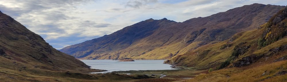
1/12/84 Bidean nam bian from Glen Etive
Route: Bidean nam bian (3766’) starting and finishing at Inbhir Fhaolain (Grampian Mountaineering Club hut in Glen Etive) 7 hrs, 9 miles approx.
Myself, T. Walmsley, Alister and Fiona, were accompanied by four others – a large party. Eight of us left the excellent Grampian Club hut. I was the Club secretary who had booked the hut. We struck up the mountainside at the edge of a plantation, to the right of a gully. Extremely steep. We gained the summit after 90 minutes. Along the ridge the north-facing slopes were slightly corniced. We saw the Lost Valley. In the distance, Nevis, with a light stripping of snow on the shoulders. Good ridge walking.
The weather went from good to merely OK, though visibility remained. It was biting cold. I suffered from terrible cramps in the hip on the second top, Stob Coire Sgreamhach. From here to the highest top was the best bit. The snow curved away steeply for nearly a thousand feet on the North side. Our ice axes were as yet unused and still strapped to the back of our rucsacs. Don’t slip here!
From Bidean nam bian we took ice axes in hand and descended over icy rock and scree and the occasional snowfield. The snow was safer; there was insufficient ice and snow on the rock for crampons, but boots alone were not adequate on the icy rock. We were happy to have axes for security. The slope grew steeper and steeper, ever icy, and turned into a series of gullies. I would have roped up here and incurred some serious delay in exchange for security, but we all descended that gully free without mishap, but causing a good deal of rockfall. The gully took an hour or more of serious effort; so concentrated an effort that we didn’t notice how tired we were. We cleared the gullies in a long line, Tim at the front, and Ian far in the rear.
As we descended, we saw a strange effect at the col far below (Bealach Fhionnghail). Clouds materialised (or perhaps “condensed” is the better word) in the left-hand glen, and flowed like a river over the col into the right-hand glen. This was picturesque in the extreme, especially at the start, when streamers of cloud (presumably resulting from a temperature inversion) swirled at speed over the col. It increased in magnitude until the col, and in due course both glens, were lost in a swirling, seething mass of white cloud. The beauty of it! It was too big to be photographed. It was a remarkable sight, deep in the mountains.
We stopped for a bite to eat, descended to a col, and from there over extremely difficult ground down the very steep river valley of Glen Fhaolain. The low clouds had cleared, and we walked in winter afternoon overcast through a trackless valley. The valley and the forest beyond it fell to brute effort, though our party got split up in the woods and we spent some time in failing light pushing through pine trees, branches and twigs whipping at us. We came to a weir on the river, crossed the river and met up with the others. We reached for headtorches, and continued back to the Grampian hut as the sky faded to blue.
