13/1/86 Stob Coire nan Lochan
Route: Stob Coire nan Lochan via the Lost Valley. Seven hours.
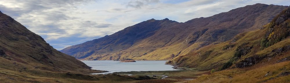
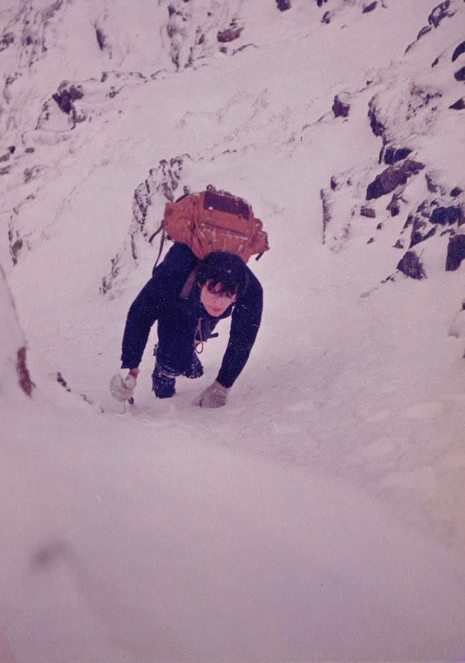
Myself, T. J Walmsley, M. Taylor and W. Wallace accompanied Raymond and J.T up into the Lost Valley; difficult work through pouring rain, rattling wind, and muddy, leafy valley floor. We split up near the thirty-foot boulder; the four of us tramped across the floor of the Lost Valley, and then, up and over fresh snow. A stream bed became a ravine, then a gully, as we climbed higher. The snow was deep and wet, and leading was a bind – tiring work. Far easier to follow in someone’s footsteps. A picture of life itself.
Moving upwards we could look back on our footprints, a line of steps over the steep snow. Sometimes the snow grew harder; at one point I had to cut steps up a steep step onto shallower higher ground. We climbed into a couloir and the light was such that the snow seemed featureless; we could no longer even see our own footprints. Distance seemed to mean nothing. On the left, cliffs. Ahead, the headwall of the corrie and a col. To the right, mountains heaped up. The last fifty feet of snow up to the col was rock hard; we just cut steps up it.
On the ridge, the wind was coming over gale force. A person could not admire the stunning view in the teeth of the wind, but that the wind would bring tears to the eyes and fling their breath back down their throat. We took lunch in shelter below the ridge, but it was still cold and windy.
After lunch, crampons on, and along the ridge towards Bidean nam Bian – but we had to turn back; it was just too windy too continue. We thought to withdraw, but decided to continue in the opposite direction, towards Stob Coire nan Lochan. This we did, staying on the windward side over mostly very hard wind-slab – good snow for crampons. We made the summit, and continued onward. Clouds gathered out west. We stampeded down a rocky east slope over very hard snow, passing the tops of several named ice and rock routes – Twisting Gully, SC Gully etc. We needed to find a gully we could descend glissading; we rejected several before finding an obviously straightforward snow gully which we started down. [23/1/21 I’d suggest looking at the map that we descended somewhere slightly north of Pinnacle Buttress.] At first with caution, and then with wild with abandon, a swooping glissade. Two of us climbed back up to do it a second time, so much fun it was.
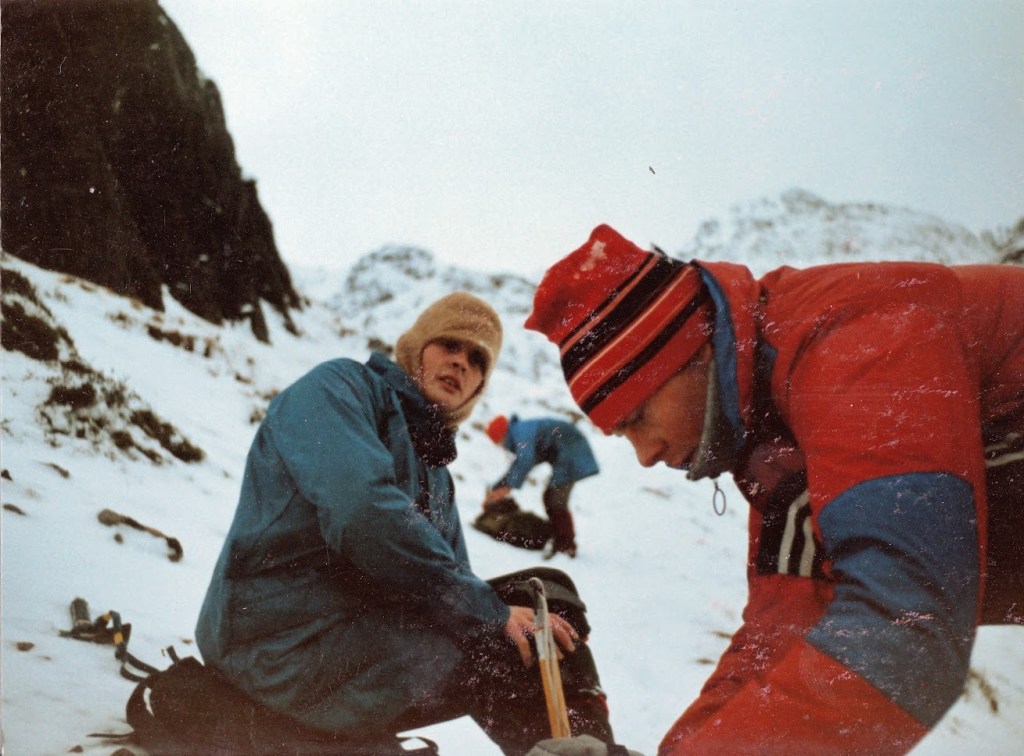
Then down into Coire nan Lochan. An Allen bolt on my right crampon got lost, but one of my colleagues had a spare. Another glissade; a lot of straightforward walking, and in the end we could see the minibus in the distance in the car park on the Glencoe road. Ray, J.T and “Climbing” Nigel could be seen throwing stones at us. A good day!!
1/2/86 Winter traverse of the Aonach Eagach
What proved to be an excellent day’s mountaineering started at 9.20a.m when five us – M. Taylor, D. McAuley, R. Carter, a fellow called John and myself, left Rob’s car at the top of Glencoe near the white cottage. The snow lay uneven on frozen grass, as we read with interest the warning sign “Do not leave the ridge before Sgor Fionnadh”.
The approach lies straight up the side of Am Bodach, a tedious slog. It was redeemed by the ever-changing view of Glencoe unfolding behind us. I approached this day’s work with trepidation, and was accompanying persons with more rock and ice experience than I. For hillwalkers, the Aonach Eagach is potentially formidable in winter conditions. It is a grade II ice route, and even the blase Nevis guide warns that parties must move fast to complete the route in daylight. As a matter of comparison, it has several miles of the kind of sharp, challenging ridge traverse mountaineering of which there is on Crib Goch, at most perhaps a couple of hundred yards.
After around 90 minutes we reached the summit of Am Bodach in mist. The route runs north from there along the ridge, then swings west, arriving at the first technical difficulty, down a forty-foot rock cliff. Darren managed OK, but the rest of us were lowered off by Mick Taylor, who then descended to the left, swearing a lot, but also saying things like “Grade II – easy”. One of the non-climbing three of us appeared unable to tie a bowline and also had no crampons – he had an epic day! [23/1/21 I’m tempted to omit this anecdote…it seems unreal – but there were practicalities involved: he it was whose car we used to get onto the hill.] At that point a party of two wearing Glenmore Lodge caps were level with us. We moved on.
The next problem was an “awkward slabby descent” according to the guidebook. We went down this using a rope as a handrail. This was followed by a lot of sharp ridge walking. Our weaker colleague needed coaxing along some of the sections, particularly over the all-too-frequent “bad steps” over deep gullies going down a thousand feet. He was lucky to get along the ridge at all.
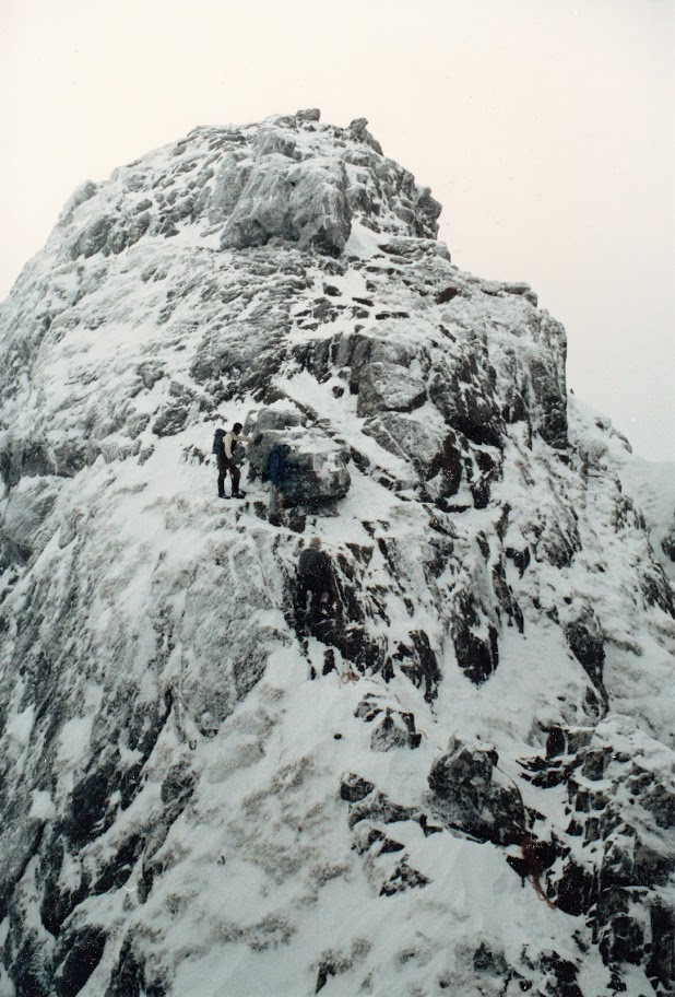
Along the way one or two pinnacles posed satisfying and interesting rock problems, made all the better by the exposure (though I seem to recall it was not a clear day and we were in cloud much of the time) but tricky in crampons, particularly – as happened on one occasion – when one of your crampons gets stuck in a crack about eight feet up. Fortunately I was in balance and in control at the time, but it was a hairy few minutes before I managed to work it free. I noted at the time that this would be a first-rate scrambling trip – very extreme hillwalking – in summer conditions.
We continued up and down over sharp, steep and frequently icy mixed ground. Worried by the guidebook’s estimate on the time taken for the route, we endeavoured to hurry, but there were parties ahead of us and behind us – it was a busy route. A sloping rock chimney, followed closely by a sharp, steep descent, followed in turn by a huge pinnacle, proved to be the most entertaining parts of the day’s work. We had the rope out three times. As a hillwalker I would not advise trying this route in winter conditions without a rope and knowing how to use it.
The route ended in late afternoon, on easy slopes, as a ray of sunshine touched the valley floor below. The way down was a glissade or bum-slide down to the top of Clachaig Gully, then turn to the right and descend over really steep, very difficult ground, frozen rocks and scree, to the Clachaig. We arrived there at dusk after a very satisfying, tremendous day’s mountaineering.
I have a memory of sitting afterwards in the warm of the chalet we’d hired, having microsleeps – but being woken from them by dreams of falling. Interesting to note what five or six hours of concern that you might fall, five or six hours of extreme concentration, can do to the subconscious.
2/2/86 Sgorr Dhonuill and Sgorr Dhearg, Ballachuluish
We left the car around 10a.m, at a layby on the main road, probably near the chapel. Five of us – the same party as yesterday – moved off up a forest road which wound for miles it seemed, through the woods, before swinging round to the left and south, rising into Gleann Chaolais. Soon we were hiking through six inches of snow. One person turned back (the same person who had been yesterday been dragged along the Aonach Eagach without crampons).
We crossed a stream deep in a broad and tree-lined valley. A spur of the ridge, forming two corries, towered snowy over us. Through trees and about fourteen inches of fresh snow, we continued until we got to the tree line. At this point, where we were afforded the prospect of a grey rocky corrie above us, another of our party turned back. This left the three most experienced mountaineers to continue.
What seemed to be the longest walk-in for ages continued, right up into the corrie – Coire Dearg. Pausing only for a bite to eat and to strap on crampons, we started up the eastern wall of the corrie. The weather improved as we climbed steep hard snow and frozen grass; patches of blue sky began to appear. As we gained height it grew brighter, and more distant peaks began to appear.
We came across several strangely multicoloured icefalls, which we attacked with vigour, but the ice “dinnerplated” after a few blows, peeling off in the shape of large saucers. Darren led up a steep rock/ice corner, which was interesting work, given the exposure and the slope. Above this was a slabbed snowfield, which he and trampled up, releasing great slabs of snow onto Mick’s beleagured head as he battled up the corner below. To the right above the snowfield there was a narrow ribbon of iced-over rock above a steep grassy step, bounded by bare rock on each side. I arrived below it as Darren got stuck on it. To my surprise – for he rarely put a foot wrong – he needed guiding down from it. I was surprised until I tried it myself. Getting over the grassy step was OK, but the ice beyond proved too hard with only one ice-axe. Two were needed to obtain purchase.
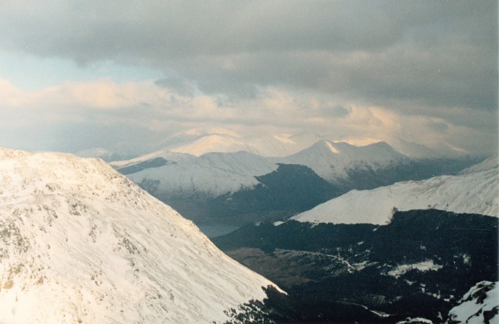
Conscious of the hard snow below, over which I would quickly slide to my premature demise if I slipped, I started to withdraw. I changed my axe hand back and forth several times and used hand-holds. Sometimes I hung on with both hands. Getting good axe placement for security was a problem. Just as I was starting to be in danger of cramp, I succeeded in withdrawing safely. We turned the route to the right, over aa very exposed iron-hard almost unbreakable snowfield above a band of rock. After a few dodgy axe placements, it became merely very hard work, crampons and axe, until we reached the summit ridge where wind and sun played.
Once all three of us were up on the ridge, we moved along over rocky ground ruinous to crampons. This continued through the afternoon. We glissaded off one peak after an impressive steep section, slogged up the next, and witnessed strange chutes or fountains of spindrift shooting up from the tops of the gullies, in rows along the ridge. After Sgorr Dhearg we glissaded down into another north-facing corrie (Coire Giubhsachain – don’t even ask me how to pronounce that!!) and continued, in the shade now of course, down the valley to the tree-line. Once in woods, there was even more variety – crawling through dense stands of pine, rock-climbing down waterfalls, slipping down muddy slopes, exploring deep, damp mossy ravines for a way ahead. By good luck we managed to find a path and get out onto the road before it was dark. A brilliant, excellent day’s mountaineering: we were well and truly knackered and still had to motor all the way back to Wearside.
By the time we were ready to set off, it was dark and the wind was rising. As we sped up the main road through Glencoe, we could see a series of lights on the mountainside, little specks of torch-light, each one a mountaineer hurrying downwards in a little circle of light towards dinner, each one with a story to tell.
8/2/86 Coniston Old Man in winter
Brim Fell – Coniston Old Man – Dow Crag – Grey Friar – Swirl How (winter)
Five of us left the hut and walked up the path, passing two of our climbing contingent watching other climbers attack the Low Water Beck ice-fall (Grade III). Myself and my usual partner in crime T. J Walmsley were accompanied by three others.
A tedious slog saw us into the Low Water corrie in deep snow, where we practiced ice techniques for a while on a large, gently sloping icefall. We went on up a gully to the right of Low Water Crag. Apart from a steep grassy step, it was easy snow climbing, bringing us out onto the unconscionably cold and icy summit of Brim Fell.
In mist we continued south along the ridge, which looks quite alarmingly sharp in winter conditions. Snow can sometimes have the effect of making the British hill look alpine, giving the appearance of difficulty to what is merely straightforward. Coniston Old Man was iced over, but not completely covered; the Lakeland summits are not high enough to permit a serious build-up of snow. We left north, as the mist cleared to reveal Goat Hause and Dow Crag. We stopped for lunch at Goat Hause and continued across rather rough mixed ground – hellish on the crampons. This would be scree in summer and there would be a perfectly obvious path to follow. We were aiming for a snow gully at the northern end of Dow Crag. The first section was just drifted snow, but soon it became some rather trickier frozen-over grass and rock steps. Nearer the top we moved over a rocky rib into the next most southern gully, which was well in condition, packed with hard snow, especially near the top. It twisted away below us down to Goat Water.
This was fulfilling and satisfying work, a great end to the route as we scrambled out onto the summit of Dow, to clearing weather and the sight of the Scafell massif absolutely plastered in snow. The weather was photograph-clear. From Dow, we considered our options, and moved onto Grey Friar. When we got there, it was cold, and windy, and we were becoming rather tired. We thundered around the hause and up the gentle slope to Swirl How.
From Swirl How there is a very steep ridged descent – the “Prison Band”. This was excellent sport downhill to Swirl Hause, and from there, down to Levers Water through a good foot of soft powdery snow. That was hard going. In the sky, pastel hues of pink and yellow, a beautiful evening in the making. A grand day. Down past the iced-over quarry roads in Coppermines Valley, arriving at the hut around 5pm.
9/2/86 Bow Fell and Rossett Pike from the Old Dungeon Ghyll, winter
Three of us thundered up Oxendale from the ODG. It was very warm. I was walking in a sweater with the sleeves rolled up. Never was I so warm in winter. Eventually we got to the snow under Shelter Crag. Up onto the ridge, where thankfully it was colder. The wind had scalloped the ice into weird shapes. The Shelter itself was virtually obscured by deep snow. Tim struggled through, but Pete and I climbed up over the icy rock round the Shelter, to the top of the crag. We sat down for a rest in as good winter weather as you can get. Most of the Lake District was visible, albeit through haze. We could see yesterday’s destination, Dow Crag, to the south.
On the summit, a large raven regarded us balefully. We moved onwards towards Three Tarns; the raven flew past us and twice stopped to look at us, its curved beak and shiny black feathers a stark contrast against the snow. Ravens are ostensibly birds of ill-omen.
Down to Three Tarns, where we lunched sitting on rocks next to an icefall. Then, up steep mixed ground to the start of a gully, to the extreme right of Bowfell Buttress. It was a steep snow slope, only partly consolidated, but even so, we were up in a trice – easier than walking! We remained only briefly on the summit of Bow Fell before continuing the well-worn path to Ore Gap. Ice and hard snow ran over the drop from here to Angle Tarn; we continued down this slope, slipping and sliding, until we got to Angle Tarn, which was of course frozen, completely snow-covered and misleadingly almost invisible. We practiced ice-climbing for a while on some small 10′ ice falls, before continuing. It was at this point that we learned the hard way – fortunately in practice – that full reliance for ice climbing cannot be placed on a walking axe. The angle of dangle of the pick is such that the axe will pivot out of its placement when full weight is applied. Around us we could see ice-climbers on various of the Angle Tarn icefalls.
At Rossett Hause we looked across to Rossett Pike, and headed for a snow slope below it. It looked small and piffling, but it was a hundred feet and the steepest snow we’d seen yet. The cornice at the top was fortunately very soft and we pushed through it onto the ridge and onto the summit of Rossett Pike. Then we continued to Black Crag, before descending through soft, deep snow to the top of the Stake Pass, and thence down into Mickleden. There were ski tracks ahead of us here. We slid and walked down through soft snow to Mickleden. As we reached the snow line we experienced a kind of “colour shock” as our eyes once again became accustomed to colours – even the drab greens and browns of deep winter – after four or five hours or more in the snow. One feels dizzy, overwhelmed, one’s eyes feel overworked.
Back down the valley to the bus, arriving at 4.30pm.
17/7/86 Snowdon Horseshoe
In company with R.C.E Ball, I left Derby in shorts and sunshine, and travelled to Bangor by train, arriving in drizzle – that’s the Snowdonia experience for you! Two buses later found us straggling up the Pass in driving rain. We pitched Richard’s “Phree spirit” dome tent and sat inside, waiting for the rain to pass.
Thursday dawned changeable, clouds hovering over the high tops. We walked fast up to Pen-y-pass and on up the Pyg track, overtaking slower folk. We arrived at the start of the climb up to the crest of the ridge as the weather was starting to clear. From this vantage point, Llyn Llydaw and the buildings at the top of the pass, are both visible. We continued up onto Crib Goch, one of the best scrambles in the British Isles, and certainly the best outside Scotland. The route leans out, an expanse of red rock (hence the name Crib Goch, which is rendered in English “Red Ridge”) tapering to a thin, exposed ridge, with three rock turrets over a few hundred yards. Clouds swirled over as we picked our way carefully along, watching the screes far below as we passed over the tightrope-narrow sections. Over the gendarmes and on up to Crib-y-ddysgyl. Here we were in the clouds, listening to the sound of the little steam engine labouring up the distant Snowdon Mountain Railway. We bore on up the railway line to the summit and stopped at the crowded cafe, elbowing our way past twinky tourists.
The summit was in cloud. A tourist remarked that it seemed like November. Had the good lady ever been here in November? “Perish the thought” she mouthed, astonished. Refreshed, we left the cafe and moved off into cold, thick mist. It seems like forever when you’re up in the clouds, blundering about on steep slopes of scree and rock, trying to route-find. We staggered downwards, hearing the usual tantalising voices off in the distance. Navigation on this section, when the clouds are down and you have not yet resorted to the compass, is tricky. We sat down and pondered our position, chin in hand. Suddenly our prayers were answered; slowly at first, and then with growing vigour, green fellsides appeared as the mist cleared. Below and to the right lay the vasty green of Cwm Tregalan. The clouds moved higher and the Watkin Path became clearly visible. The ridge between Yr Wyddfa (Snowdon’s main summit) and Y Lliwedd appeared, followed swiftly by the grey towers of Y Lliwedd itself. Our way ahead was now clear; we launched ourselves gratefully down and to the left.
Behind us, Snowdon itself remained under grey stratus. Warmer now than at any other time in the day, we continued, impressed by the magical beauty of Llyn Llydaw far below, its surface a transcendent blue. Y Lliwedd is a tall, sharp hill, worth climbing at all times. The route lies up the edge, close to its Northern precipice, a startling near vertical-looking cliff hundreds of feet high, grey and sheer. One scrambles easily up to the twin summits. We sat there in sunshine, before continuing down the grassy slopes to the Causeway.
A grand day’s hillwalking, in improving conditions, my fourth Snowdon Horseshoe traverse. A good day out in summer, it would probably be a magnificent expedition in winter conditions. Another day will come.
The following day, we walked from the Pass through to Cwm Idwal, down through the Devil’s Kitchen. A nice little easy pass through to the Ogwen valley if you have no car. It’s a good slog with big bags, and not too boggy. Going downhill through the Devil’s Kitchen is always in order – shouldn’t fancy coming up this way. Amazing views of the Idwal Slabs from above.
19/7/86 Idwal Skyline, summer
“If it stops raining by eleven, we’re going mountaineering” I said, at about 9.30a.m. Ball just grunted in reply, his eyes on his book. The rain pattered lightly on the tent; the clouds looked oppressive. Eventually he deigned to put his book aside and get ready, and we set off around 10.30a.m. Measured steps along an old track saw us at the base of Tryfan, Ball having tried without success to charm a lone young lady from Southampton who we met along the way. I grinned inwardly and steamed upwards over the heather. It was 11a.m. The lower slopes, heather and grass, give way to bands of cliffs up which we eagerly scrambled. The A5 soon shrank to matchbox car proportions, a thin line winding along the lake.
Eventually the rock proper begins. I clambered onwards, far ahead of Richard who chose to take his time, savouring the delights of scrambling up the best mountain in Wales. Tryfan never fails to delight the scrambler or casual climber – a veritable delight of routes up good, rough grey rock. Quickly I gained height, choosing, as far as possible, the testing bits rather than the worn pathways. The summit of Tryfan is rarely visible whilst on the north ridge, as the ridge is stepped into terraces. Grey towers up ahead are the tantalising target. The cross-cutting clefts – one of them called “Heather Terrace” are one of the few places where everyone follows the same path. I got to the summit in 77 minutes – a personal best for Tryfan. Rich arrived, at a more leisurely pace, almost half an hour later. He polished off my remaining orange and set the food-consumption rate for the rest of the day.
We continued, trying our best to down-climb rather than walk, down to Bwlch Tryfan where my companion insisted we stop for lunch. I gave in graciously and we sat quietly eating lunch at the col. Then, quivering in anticipation almost, for the afternoon’s work, we arrived at the foot of Bristly Ridge. We climbed and climbed, enjoying ourselves. This section was most enjoyable – an almost endless progression of easy rock that grew sadly easier as we approached the summit. Behind us, Tryfan was a tooth. From the sun-drenched summit of Gylder Fach, though, it looks positively diminutive. Strange shards of slate stand up in clusters on the summit, giving it a rather fantastic look, as if in a scene from “The never-ending story” or other such film.
Out in front again, I continued along to Glyder Fawr in warm sunshine, seeing Snowdon dark on the left, and the Nameless Cwm on the right. Arriving on the summit, we met again with the young lady from Southampton, who complained of a painful knee, and continued downhill in her company, ostensibly helping her. Richard abandoned his position as obliging gent as soon as it was clear she was quite happy on her own and stampeded off down the screes at a suicidal rate. I went downhill a little slower, particularly after falling on my arse at one point. At the bottom he gazed wistfully up at the slopes, to the girl with the painful knee, and we continued.
Up Y Garn, where there were a few specks of rain out of nowhere, it seemed. Oddly it’s always cold and windy on Y Garn. Today was no exception. We sat at the top, looking down the slopes into Cwm Idwal, noticing the grey clouds swirling over Glyder Fach at 3200′, whilst the Carneddau on the other side of the Ogwen valley, remained clear of cloud at 3400′ and higher. The last movement of the Idwal Skyline is down the sharp arete above Cym Clyd, which is again as on the Glyders, punctuated by sharp upstanding slates. A wise place to walk with your hands out of your pockets. We arrived at Idwal Cottage well satisfied, at about 6pm, and met some Venture Scouts of the 73rd Derby (Viking Venture Unit) waiting for Pete Mitchell to arrive in the minibus and pick them up.
Chips and steak pie at Idwal Cottage, made us feel brighter by far, and deeply content, we tramped back along the A5 to our tent on the far side of Tryfan.
24/7/86 A walk on Kinder
Today was the day of the Royal Wedding of Prince Andrew and Sarah Fergeson. Me and RIch Ball went hiking instead. We left Edale about 10.30a.m and ran off up Grindsbrook. As we neared the top, a rain shower turned heavy, and we waited as it drove down-valley, a grey stain along the skyline.
The peat hags were steaming gently in bright sunshine as we moved over the flat and desolate sea of heather. Up here on Kinder, the flatness envelopes you. We arrived at the “summit”, more of a gentle watershed marked by a cairn, and from there, navigated by reference to the Holme Moss TV transmitter tower, a tall thin mast, its warning lights a-flashing periodically, some 16km to the north. Crowden Head was replaced by the dry bed of the Kinder River, which led us to the Downfall. As we lunched at the Downfall, large and sturdy sheep appeared, until around fifteen of them stood around us patiently waiting for titbits. Black clouds swooped by, darkening the fresh blue skies, soaking the good citizens of Hayfield far below.
From Kinder Downfall, north, followed closely by another line squall. Swiftly, as the skies grew dimmer, we sought shelter under a block of gritstone and waited for the squall to pass. It blew itself out after a dozen minutes or so, and we continued, now again in warm sunshine, advancing along a gentle scarp, past the white front of the Snake Inn far below, past the steep Seal Stones path downwards. We arrived at trig point 1937′ and rested for a while in warm summer sunshine. In the distance, Win Hill was a square grey top. We followed paths downhill through heather past crumbling outcrops, onto the lower moor, Crookstone Hill. In the distance, Ladybower reservoir was visibly empty. As we walked, there were a few mutters of suitably distant thunder. Along the moor, great clouds of blue and grey heaped up behind us, motivating us to hurry. Shelter was far ahead, in the woods at the edge of the reservoir.
A dense squall rushed past on our left, thunder began to crackle, and lightning fork cloud-to-cloud and onto the surrounding tops. Heavy rain began to fall. Lightning flashed again and the rain turned to hail. We flung ourselves into a ditch, hiding our heads from the hail, and then dashed for cover behind the shelter of a stone wall. Hail fell…and when it was over, the world was white like winter. It was amazing to behold. We walked in deep cold past a group of terrified pony-trekkers, their mounts as scared as any of them, down to Hope Cross and along. Fresh clouds gathered, and we tarried a while, hiding from the real risk of being struck by lightning.
Clouds back of us, we continued down the track to Hope. Hail came again, almost painful as it battered our legs, heads and backs. Water ripped at the track, a veritable flash flood, and we were grateful to leap into a Land Rover when a lift was offered. Being driven through the hail-covered lanes to Hope, we reflected that this was the most startling thunderstorm we’d seen for some time.
29/7/86 Helvellyn and Fairfield
This was a walk off the back of the 135th Derby (Broadway Baptist) summer camp at Loughrigg or thereabouts. Myself, A. Mackervoy, S. Burns, S. Giller, J. Clarke, J. Mew.
The rain came down in ropes as the van lurched past the rhododendron-lined village of Patterdale. As we set off, it was noon. We pounded up the path in the rain. Steve B burned off ahead and set a tremendous pace up the long, steep slog up Grizedale Brow. Drizzle persisted all the way, while the clouds kept the hills well hidden. After a while we regrouped at the crest and moved together through the mists towards Helvellyn. Driving wind steamed up the right-hand lense of my glasses, causing me to lean to the left, and the rain ceased to be a problem.
After a while, rocks loomed up – Striding Edge. Along the edge was fun; it was seven years since I’d last been here. Up onto the bulk of Helvellyn, a tedious final slog, to swiftly cap the summit in thick, swirling mist. We thundered onwards and downwards, getting very hungry, along the Dollwagon Pike/Nethermost Pike ridge, almost missing the zig-zags down to Grizedale Tarn.
When we stopped for a very late lunch at 3pm I was frustrated and demoralised. After eating I was bounding up and happy – a classic demonstration of the importance of maintaining blood sugar levels on the mountain by eating “little and often”.
Down to the tarn, then up Fairfield, and over through the mists to Greatrigg Man. At the last top, the clouds split wide open and the sun poured down onto the surrounding countryside. The clouds lifted and we moved through bright country air down over Rydal Fell, down the Nab Scar erosion path, on to Rydal itself, thence over a gentle pass in the early evening sunshine, back to our campsite at Loughrigg.
1/8/86 Ordinary Route, C Buttress, Dow Crag
Myself, A. Mackervoy and S. Giller walked into Dow in pleasant warm weather, and chewed our butties sat by Goat Water, as the weather cooled somewhat. It was slowly but surely deteriorating; already grey cloud was replacing hazy blue sky.
With some trepidation, the lads followed me up the screes to the foot of C Buttress, where we climbed into harnesses. Some of my colleagues were not confident; I was leading this as the most experienced in rock climbing. I led, straight up, easy enough climbing. I had someone on the rope below but it was a formality. I made an error notwithstanding, climbing two pitches rather than one and running out almost the entire rope. As a consequence, I could not see the people I was belaying up the climb until they were almost half-way up.
Moving upwards I kept the subsequent pitches much shorter, 50′ or so, always remaining in sight of my second. The only really memorable bits were a slab above the top of the third pitch and some delicate opening moves to the final pitch. I led unprotected except on two occasions when I stuck some metal in to protect me and tide me over a hairy move – and there were few enough of them.
The exposure (literally awful) and the rock scenery were tremendous. This is rock climbing as mountaineering rather than gymnastics. Technically very easy; there are more difficult and more complex moves to be found on the Bristly Ridge of Glyder Fach.
