About eighteen months ago I went to the Lakes for a bit of wild camping. In the final paragraph of my trip report here, I wrote this: “had I known that public transport in the Lake District was so comprehensive and so well co-ordinated, I would never have brought the car at all. From where I live in East Surrey, the train would be about the same journey time, maybe slightly quicker, and a good deal less tiresome than trudging up and down the M40 and the M6. The train might cost a good deal more than the cost of the fuel – but as any fule kno, the cost of fuel isn’t the true or full cost of motoring.“
I journeyed to Windermere by train. Leaving my home in East Surrey just before 0700, I was in Windermere just after noon. It is the Pendolino tilting train that makes this worthwhile and possible, from Euston to Kendal in three hours. The cost was not excessive at £133 return in standard class. After a scotch egg and a bottle of pale ale sat in a sun-soaked corner in Windermere, I took bus 508 up Kirkstone Pass, for £5.10, with a very cheerful and friendly driver who said, “It’s a while since I’ve driven this route. Let’s hope I can remember it”. There were two other passengers.
At the Kirkstone Pass Inn I hopped off in bright sunshine. As I was rigging my bag for hiking, seven or eight motorcycle warriors of one tribe or another roared through on their throaty Harley-Davidsons. It was 2pm. Grinning and confident in physical fitness, I set off up the hill, and was on the first top, Red Screes (776m). From there, along to Scandale Pass and little Scandale Tarn. Here there was a squall and in five minutes I went from using a sun hat to wearing gloves. That’s the Lake District for you – never underestimate the mountains. Further on, to Dove Crag, Hart Crag and finally Fairfield (873m) whence I arrived at 5.10pm. I’d been this way before, some time in the 1990’s. Here you can see the difference between winter and summer conditions:


The first time I was on Fairfield was in shouting rough conditions in about 1979 or 1980, with a school party on a YHA trip. It would hardly be allowed now. From there, down to the somehow ever-gloomy Grizedale Tarn. It is a long way down. Another location with deep memory for me, from that same YHA trip, only the second or third time I’d ever visited the Lakes.
It was with some difficulty that I found a place to pitch my tent. The aspect was geographically similar to that tarn in the Cairngorms (Loch nan Stuirteag) where I’d experienced difficulties last November. A high tarn flowing east down into a wild valley, no obvious camp ground at the outfall and a rising wind. But, a place to camp I found, by the babbling brook, and soon enough it was supper time: fresh tortellini and a tin of 8% stout. I was drowsy; I hardly thought at all. I was in bed asleep well before 9pm. I found that lying in my sleeping bag in the tent, listening to the babbling of the brook, I could be in a place where I was not thinking about anything: awake, but barely even conscious.
I was wide awake by 6a.m and set off at 8a.m, tent dry, ready for adventure. I was on Dollywaggon Pike before 9.30a.m, and from there to Nethermost Pike (891m) and onto Helvellyn (969m) before 10a.m. The first and strongest of the day-trippers were already there, some Scotsmen with good camera equipment. Absolutely stupendous visibility!! Just look at these below. I spent some time talking to the Scotsmen, reflecting that the last time I was here was in winter conditions in 1997.


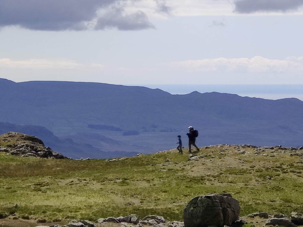
And then, down, through the long morning. Although earlier on there had been few enough people on the mountain, I passed many dozens of folk toiling up the long and arduous ascent of Helvellyn from the Thirlmere side. Why would anyone climb Helvellyn from that side? A dreadful slog, it is. I suppose the ascent from the Patterdale side, involving as it must, either Swirral Edge or Striding Edge, is not for everyone. And not for me, is that steep downhill to Thirlmere: by the time I got to the valley floor, about 11a.m, I was tired and I had stubbed toes. It was very warm and sunny – again, absolutely delightful conditions for photography.
I was starting to think, where will I fill up on water? Odd to be in a reservoir valley, yet for there to be no instantly available drinking water. Water, water, everywhere, but not a drop to drink…there was a long and somewhat tiring slog through admittedly delightful woods up along the eastern shore of the reservoir, as far as the dam, where I stopped for lunch. Boots off, charge my devices, and sit in a sun-soaked corner. Lunch was bread and butter, cheese, tomatoes, and a little Chorizo sausage. An orange, some chocolate and some trail mix. I drank the remainder of my water. Now I really needed to fill up.

As I set off again, a trio of hikers passed me, two young women and a young man, all festooned with clanking cups and pans and camping equipment hung on their rucsacs. I confess I don’t like it for there to be any stuff attached to the outside of my rucsac. I prefer the clean lines of climbers’ rucsacs and generally don’t even do side-pockets if I can avoid it. One of the girls stopped to chat. It seems that they perhaps, did not realise when they arrived last night, that camping is strictly prohibited on the Thirlmere valley floor. I was just pleased to hear someone speak in a Lancashire accent, whatever this youngster was telling me.
At Armboth, I managed to fill up my water bottles, though I deemed it necessary to add purifying tablets. Onwards and upwards literally; the second ascent of the day, from Thirlmere up over the moor to Watendlath. I shouldn’t have cared to come through here in claggy conditions; the moor, as well as being boggy, was pathless and featureless; one should find oneself very soon resorting to the compass in poor visibility. Initially it was a very pleasant walk through steep meadows with unusual flowers, leading up onto a rather boggy moor. I found this hard going as it was now mid-afternoon and I was carrying 3kg of additional water. And so it was that for the first time in my life I found myself visiting the little hamlet of Watendlath, nestled in a hanging valley between Borrowdale and the Thirlmere valley. There was a tea rooms, and I stopped for a pot of some of the best tea I’ve had for ages, along with some rather nice tea bread. It was 4pm.
From Watendlath, one skirts the eponymous tarn and sets off up a good bridleway to Rosthwaite in Borrowdale. This was an ancient, traditional and much-trod road. It made me think of those many passes of Lakeland through which there is no tarmac road. Sticks Pass across these very moors. The Walna Scar Road between Coniston and Dunnerdale. The Black Sail Pass from Wasdale to Ennerdale. The Scarth Gap between Ennerdale and Buttermere, and the biggest and most important of them all perhaps, the central pass of the Lake District, Sty Head between Borrowdale and Wasdale. There will be others. I came down towards Rosthwaite late afternoon, again, in glorious sunshine, with the aforementioned Sty Head pass visible in the distance, as well as the bright specks of distant cars in the Honister Pass reflecting the sunshine. And all the time, the sound of lambs, and occasional cuckoos.

At Rosthwaite I stopped at about 5.20pm for a pint of ice-cold lager, primarily so I could sit in range of WiFi and update my wife on my location. Though the pint was very welcome, it was secondary to my purpose. Clearly EE don’t have a mast in Borrowdale.
Onwards: first, another tiresome road tramp along around 2km of tarmac, before turning left into the fields again on a path to my final destination today, Tarn at leaves, where I planned to camp. Though at best 2km from the road, it was strongly upstairs, really quite steep. The sun was at my back and though I was flagging towards the end of the long day, I knew I needed to get there. “You’ve got this” I told myself, and I had. I was a little concerned though, that there were no paths onwards from Tarn at leaves. This concern had some justification; the map, as far as it goes in terms of detail (which is not far even on the OS 1:25000 sheet) showed none. But this isn’t the Cairngorms in November. I finally got to the tarn and found it very boggy, going in up to my knees and getting my boots wet right in the last two minutes of an immense twelve-hour day on the hill. But it all dried out quick enough.
I was sat down to my supper quite late – about 8.30pm. For supper I had spicy red lentils, and a chick pea flour pancake – a “faranata” the recipe for which I learned from my son Nat. I can’t be doing with not eating and drinking well when camping wild. To wash my dinner down I had some remarkable and very tasty 8% proof “Sling it out Stout” (though to be fair after that walk of nearly 25km, even Carling Black Label would have tasted like nectar. Well, that’s pushing it a bit, maybe…
The place was well deserted. Though I was happy enough, it reminded me of a sad part of Tolkien. Hurin, released by the devil Morgoth after 28 years in captivity, wanders over the land trying to find the hidden city of Gondolin, whose king Turgon, was once his friend. He knew roughly where it lay, but not exactly. And on some deserted moor, where the wind whistled endlessly through the grass while no-one was listening, he cried out in grief and rage, “where are you, O Turgon, in your hidden halls?” But someone was listening…Morgoth’s hidden servants reported those words back, and the betrayal of Gondolin began.
This tarn is one of those past its former glory, slowly drying out. Slow by no human perspective – it’s climate change alright, but not as we know it. It’s nothing to do with man-made climate change. Tarns like these have been drying out in the Lake District since the ice receded these 10,000 years. There are dozens of them. The word “moss” is often a giveaway, for example, at the Great Moss under Scafell Pike: even a cursory glance at the map tells you there was once a lake there. For all the boggy areas in which went up to my knees when I arrived in the evening, it was a dry camp and a dry strike. After a breakfast of mushrooms, spinach and fresh coffee, I was away again by 8a.m the next morning. What I could not do, is find fresh water to drink. I set off onto the hill with less than a litre of water left, but with a few little oranges and tomatoes.
It was not clear to me where to go from the tarn; I did not want to end up scrambling up and down bands of cliffs: unwise at any time if you’re on your own, a recipe for a coffin or worse if you’re carrying a 20kg rucsac. Once you stumble, down you will go. Don’t stumble!! I pressed on, keeping the dark and seemingly endless (and appropriately named) valley of Langstrath on my left. I remember being in it once on a rainy day, thinking it went on for ever. And I found a fence. Where a man can build a fence, I can safely walk. I followed that fence for quite some way before leaving it, saying farewell as to an old friend, and striking uphill towards Glaramara (783m). I was an hour and ten minutes walking this morning before I encountered a path. That is unusual for the Lakes.
Glaramara unfortunately has a short scramble which I did not recall from last time I was here (which to be fair was 36 years ago when I was a callow youth.) But keeping one’s weight forward works for climbing with a big bag; slightly less unnerving than climbing downward face-out, when the weight and centre of gravity must be kept back to avoid to avoid toppling over and down. I did not expect to see anyone here this early (9.30a.m) on a Sunday morning – way too early for day trippers to get to this location. The summit was deserted and cold. For a short while it was cold enough for me to wear my woolly hat. On the next summit I did in fact meet and have a pleasant chat with a young backpacker, who had camped on the shoulder of Scafell Pike at over 950m above sea level. We spoke of obtaining water; he noted that water flowing in streams off the central massif could be polluted and a problem: he was planning a two-night Mountain Leader Training exam expedition soon, and obtaining water in summer conditions, was a challenge. I was drinking water I’d carried all the way from Thirlmere.
Again onwards to Esk Pike and Esk Hause, the central col and cross-roads of all the Lake District. Also about as far as you can get from a road-head anywhere in the Lakes, although paradoxically enough, probably not the remotest location. Here there were day trippers, mostly up from Seathwaite, Borrowdale. Round here one reflects on the centrality, not of Esk Hause, but of Great Gable. It’s not the highest mountain of course, but it is the central boss, the ice-worn stub of whatever original mountain stood here millions of years ago. Near here I saw some classic “roche moutonnee” (literally “mutton rock”, rock like sheep) whereon there were clear scratches from the ice, quite at odds with the rock’s natural bedding plane, the scratches pointing towards Great Gable in one direction, and down-valley in the other. I do like the landforms left by the glaciers. The hanging valleys, the corries and cols. Truncated spurs. Misfit streams. Terminal moraines. Eskers and drumlins.
Round to Bow Fell, where I started to feel hungry and took lunch. On Bow Fell I encountered an older fellow with his young son, and he was teaching him the names of the summits on the skyline, testing him so he would learn them. I know them, and no-one taught me their names. But I am an older man and I’ve been coming to the Lake District for over forty years. My first trip was in 1977, to the Newlands valley with the Scouts, and we climbed Dale Head in claggy conditions. I remember it fondly. But it is something that would not be permitted today, for two Scouters with no Mountain Leader certification or formal training to take 16 young Scouts on a hike like that.
From Bow Fell, descending carefully, I went down to Three Tarns, where I saw that fellow again with his young son. I was most careful going downhill, though it seemed straightforward enough. I became aware that having climbed Bow Fell half a dozen times at least, I’d never come down this route, only up it. From Bow Fell, at a little after 2pm, I went down The Band, increasingly footsore, until I found myself very slow and very tired at Stool End Farm, about 3.30pm. A child was playing in the farmyard as I passed through, and my hike was over.
The geeky stuff
On day 1 I walked 9.57km; on day 2, 24.46km, and on day 3, I walked 14.28km, to a total of 48km in just a bit less than 21 hours total. On the second day, the 24km was taken over 9 hours and 49 minutes and involved four separate ascents, three from the road.
I used an Osprey Aether Pro 70 which weighed 14kg laden with no food or water. Add to that around 3.7kg of water, 900g of beer and all my food, means that at the start I was packing somewhere between 20kg and 21kg. This is a lot less than I was carrying with my previous rucsac which was about 10 litres larger but a good deal heavier. I’ve written about this before.
I slept in an MSR Elixir 2 tent, and used an Alpkit Skye High 700 4-season down bag, a silk liner, and a Thermarest self-inflating mattress. I used a small Trangia 27 and a small (750ml) metal bottle of bioethanol. I carried gloves and mittens (and used the gloves), a woolly hat and a sun hat (and used both), Goretex waterproof trousers (didn’t use) and Goretex gaiters (did use). I carried about 800g of Lithium battery power packs as well as a cellphone and a smart watch. Spare clothes, waterproof coat, fleece jacket, first aid kit, small pair of field glasses, and a few other bits and bobs, made up the kit list.
I found the Aether Pro too small for my purposes and the tent had to be strapped to the outside. But the extremely light weight of the Aether Pro carries all before it – I love that aspect of it. After a day or so I became adapt at re-packing and found things fitted better, and eventually the tent fitted inside. I have not yet had the Aether Pro out in heavy weather, so I don’t know how waterproof it is without a rain cover.
