17/4/85 Langdale to Buttermere via Great Gable and Black Sail
Route: Great Langdale (ODGH) – Mickleden – Rossett Gill – Angle Tarn – Esk Hause – Sty Head – Great Gable – Kirk Fell – Black Sail hut in Ennerdale – over Scarth Gap to Buttermere (16km, 10 hrs)
Rich Ball and myself hitched into the Lakes from Sunderland the previous day. We were up and away early in the morning under low clouds. Nothing was visible until we were well up Rossett Gill, when the other side of the valley briefly appeared. This was the time when we got drinking with a couple of Naval ratings in the ODGH. Rich, of course, could not conceal that he was in fact an officer of the Royal Navy…the result was these two ratings trying to drink Rich under the table. I seem to recall being heavily hungover climbing Rossett Gill.
Angle Tarn was briefly visible as the weather improved. There was some snow present up on the ridge. Weather and visibility improved, such that by the time we reached Esk Hause, it was a fine day. At Sprinkling Tarn we stopped for a brew and some food [we were backpacking with full kit]. The energy required to tackle Great Gable indicated this wise policy. Soon we were labouring up Aaron Slack with the sun beating down through the haze. Sometimes the mist cleared revealing the view back to Sty Head. At Windy Gap there was a party of lightly laden children. After a brief rest we continued; tremendous scenery appeared off to the ENE. We pushed on to the summit of Great Gable. There was the odd tantalising glimpse of the surrounding country, but for the most part it remained invisible, hidden behind the mists.
We moved down the very steep scree slopes on Great Gable’s east face, in thick mist, hearing voices and a stream below. “We are too low” cried Rich. “Rubbish” I replied. We were too low… Kirk Fell reared before us and we made the most of the scrambles, getting to the top in no time at all. From there we could see all Ennerdale, the Black Sail hut and Scarth Gap, our route ahead. The cliffs denied us access, so we moved round to a deep gully which gave us some real sport in descending. A rope to lower our gear would have been helpful, a big rucsac being a danger to balance.
The weather was now at it’s best; all was clear save Great Gable. We trampled out of the gully, round Kirk Fell and after a good while, down the Black Sail path into Ennerdale. This valley being full of trees and bounded by high ridges, has a very Scandinavian look about it. At about 5.30pm we arrived at the Black Sail hut and contemplated camping there. We decided to move on, and we did so, refreshed by some fizzy drinks and by conversation with an army type on a 128 mile hike.
The Scarth Gap Pass proved to be no obstacle, and we lingered at the top, absorbing the clarity of evening around us. All the hills and valleys were splendid, whether dark or sun-filled, brown, green, blue.
A steep descent into Buttermere, and we tried two campsites. The first we rejected. The second was closed. Very tired now, and very fractious, we went back to the first one and stayed there – more than adequate after such a long and tiring day on the hill.
18/4/85 Buttermere to Braithwaite – Hopegill Head and Grizedale Pike
Route: Gatescarth, Buttermere – Lanthwaite Green Farm – Whiteside – Hopegill Head – Grizedale Pike – Sleet How – Kinn – Braithwaite
The day began with a five mile road walk-in. We stopped at the youth hostel in Buttermere to take on supplies at which point a dog relieved itself all over my rucsac while it was on the ground. We didn’t hurry, but moved at a reasonable pace along the side of Crummock Water, which was a really pretty blue against the fells. The weather, which had been crystal clear at break of day, was becoming hazier as time went on. It was warm – shorts and T-shirts weather.
Rich had a pulled muscle in his thigh and this kept us a bit slow. We had to take a lunch break somewhere below the ridge of Whiteside. Above us was seemingly never-ending scree, bounded by thick heather on both sides. Difficult labour upwards. Rich was slower than I but less knackered on attaining the summit. At the top, we couldn’t see much owing to haze in the west and south. To the north, mist threatened. We moved along the ridge – this, in winter conditions, would be really scenic. We observed on one side, mist and grey; on the other, a summer afternoon, hazy and blue. Rich was still suffering from his pulled muscle.
Over some interesting gendarmes to the summit of Hopegill Head, and without further ado or delay, straight onto Grizedale Pike. From here, the path drops extremely steeply before running along a long ridge – Kinn – which brought us to Braithwaite, that village a few miles from Keswick.
An interesting point on the following day regarding the extremes of luck involved in hitch-hiking. Dickie could in no wise walk out to Keswick, so we had to hitch from the A66 right there in Braithwaite. We were taken from there direct to junction 36 at Penrith by the third vehicle that passed us. We were carried across the Pennines by the driver of a Foden freighter, but we waited more than two hours for a lift at Scotch Corner.
24/7/85 Skiddaw
Route: Skiddaw
Rich and I arrived in Keswick in early evening rain and camped up at Castlerigg. Not a great campsite. The next morning we set off late – what’s the use of hurrying in summer? Through Keswick and onwards, an ascent of Skiddaw by the basic straightforward route. Clouds about 2000’ so the last 1000; we were in the clouds. Not a difficult hill. On the summit there were some very cheeky and persistent sheep. We stampeded back down again through Keswick to Castlerigg where the weather was blistering hot. Three hours to go up and down, a good warm up day, loosening up the muscles.
25/7/85 Blencathra and crossing Sty Head in a thunderstorm
From Castlerigg into Keswick to buy jeans for Rich. I picked up some new headphones too. Then we tramped out, eventually hitting the disused railway. It was a hot, hazy, blue sky day. Under the big A66 bridge, and some of the old river bridges had a very Canadian feel to them. Splendid scenery. We left the old railway and crossed several fields to a road, which we followed down into a ravine. We stopped in the shade by the babbling brook, a lovely spot encouraging lassitude, but eventually we pushed on.
Up the hillside as the sun beat down on us – this is your Mousthwaite Combe. We laboured up a grassy path up onto the shoulder, which offered amazing views. FM radio reception was quite remarkable – we were listening to Q102 Dublin on our walkmans – in stereo. We continued onto the summit, not taking the route via Sharp Edge on this occasion. We dropped back down to the road arriving at the Salutation Inn in Threlkeld for an excellent bar meal. From there after a pleasant drink, we walked back to Castlerigg in the gloaming.
Next day, 26/7/85, it rained. In a lull in almost continuous thunder, we struck camp and caught the bus to the head of Borrowdale, arriving at Seathwaite lane end. In rain and thunder we walked over Sty Head. Climbing up to the top past Taylorgill force, there had been mostly sheet lightning, but as we arrived at Sty Head tarn it started forking onto surrounding summits. We found that deeply unfunny. We left sharpish, hurrying down the Wasdale side as fast as we could. The thunder was deafening; quite a novel experience to be so close to the heart of the storm. It died off as we moved down into Wasdale. We stayed at the Barn Shop campsite, at a cost of £1/night but no showers. The following night we struck camp again and moved to the National Trust site – same cost, £1 per night, but with a shop, hot and cold running water, free showers and facilities. These National Trust campsites (one in Wasdale, one in Great Langdale) are excellent.
27/8/85 Pillar
Route: Pillar from Wasdale
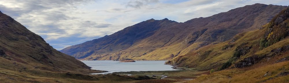
Down Wasdale and up a valley not recorded in my notes – perhaps Nether Beck. After endless tramping in the mist, we ended up on a wall where we met another chap. We learned from him that we were between Haycock and Steeple. The chap was overdressed, inexperienced and over-equipped, but he knew what he was at. He accompanied us up over Scoat Fell, down to Wind Gap, and up Pillar. Pillar required scrambling lower down, but was flat and boring further up. From Pillar we descended again, getting out from under the clouds, into some excellent visibility and scenery. Ennerdale, that tree-filled valley, looked spectacular and somewhat artificial. The regimented rows of trees, the arrow-straight fire breaks, the careful square boxes and unnatural straight lines defy nature. Would that the Forestry Commission let nature take her course somewhat more.
Down to the summit of the Black Sail pass, we parted with the other fellow who was headed for Honister Hause. We ourselves stampeded down the Black Sail pass into Mosedale, onto Wasdale and our tent.
28/7/85 Scafell from Wasdale
Route: Wasdale – Lingmell Beck – Lingmell cove – the Lord’s Rake – Scafell and off via Burnmoor Tarn
Someone at the campsite recommended Lingmell Beck as a good route up to Scafell. As both Rich and I were fit from five days of hillwalking, we did not find it as difficult as it looked. The path climbs steeply to a fork, leading into the cove between England’s two highest mountains – Lingmell Cove. Grey rock towered into the cloud on either side. The last hundred feet or so is scree, leading to the foot of the Lord’s Rake. The Lord’s Rake itself led to the right from here, very wet and greasy. We followed the route I had learned the previous year with Ian H., turning left after the first descent after the Rake. Turn left over scree and rock, into a gully. Carry on up the gully over sloping, easy rock. It was wet, and by the standards of a pure hillwalker, desperate stuff. This made up for the boring uphill slogs.
Rain now began to fall in earnest, and by the time we reached the summit, it was absolutely siling it down. We felt that to reverse the climb we’d just done, in these conditions, would be pushing our luck too far. So, we bore south, then east, towards the green notch of Mickledore. The mist swirled and there was visibility of barely 15m. And the rain came down. We saw a party struggling up a muddy gully near the cliffs, the mist and the closed-in atmosphere of the surrounding cliffs causing a cave-like acoustic effect. The gully led to Mickledore, but again, looked too steep to go down in wet weather. We had no rope.
Onwards; we eventually found ourselves in another big steep gully, full of water. We climbed down and to the left over greasy wet grass and wet rock, which was sloping dangerously away from us. As we curved across the face of the mountain, we came to a halt. A nasty corner found me temporarily trapped in what felt like an irreversible position. I got out of it by herculean effort, a muddy grass hold and dirty water down my sleeves. Scary for a moment: below was a fifty foot drop and then scree.
We continued left, and all of a sudden, we knew where we were: we were on Broad Stand. Below us, no more than thirty feet from us, was Mickledore, and there were people. The phrase “so near yet so far” was never closer to us than at that moment. We dared not free-climb down Broad Stand. It was way beyond our skill in this weather. A rope might have helped us and changed the course of the day, but it was not to be. And so, wearily, we turned back.
Back, over the rock shelves and platforms, to the gully. In the gully I dislodged the greatest rock I ever dislodged in my life – easily the size of a small car. This huge boulder bounced down the gully, and there was a sickening silence as it fell into space, save for the rattling of smaller rocks and debris. The rumble of that minor landslip seemed to go on forever. Four is the number of times I shouted “BELOW!!” but the mist seemed to muffle my voice.
On regaining the plateau, we bore west over wet grass and scree for a seemingly endless time, until we dropped below the clouds, and sodden and tired, we saw the Burnmoor Tarn far below. More thundering downwards in wet boots, over flooding streams, through waist-high bracken, down into Wasdale. A very full day on the mountain, and the descent in the rain shook my love for the Lake District to the foundations. We struck camp the following day and headed out, our week over.
16/8/85 Bad weather with an inexperienced partner
At a dawdle we left the side of Derwentwater and proceeded up Cat Bells. It was a lovely day and we could see for miles. I had brought my girlfriend to the Lakes for a few days, to let her see what hillwalking was like. We continued over High Spy, and boggy High Scawdel, and thence down to the Honister Hause arriving at 3.17pm. We could see Buttermere and Crummock Water. The cliffs looked tremendous – Yew Crag and Honister Crag.
We left the top of the pass at 4pm, refreshed, and moved on up the ARROW STRAIGHT bridleway up Fleetwith. It grew cloudy, though not excessively so. It was windy, but not so as you’d worry. So far it had been good. Borrowdale was visible and May Crag on Hindscarth looked especially eye-catching. We turned off the arrow-straight bridleway, intending to contour round to avoid the up-and-down. We passed over endless vast tracts of bilberry and heather. Every so often, a splash of rain.
We got around and were back on the path to the top of Haystacks when the heavens opened. Or perhaps hell. Pouring rain and force 4-5 winds came up very quickly. We’d lost time in contouring round, and we struggled on. I was ill-equipped. I had ONE waterproof coat, no waterproof trousers. She was in trainers. I had no bivvi bag, and no reserves of emergency food. Considering all this we escaped lightly: And I was solely responsible.
With her in my Kagool, we struggled over Haystacks in the teeth of the wind and driving rain. She was becoming tireder and more exposed by the minute, much less fit than I, ill-clad and unaccustomed to being outdoors in such conditions. Eventually we could see Ennerdale below. Our troubles were not over. It took more than an hour to descend over screes and past cliffs. I was addled myself, being very wet and cold, but I realised she needed to be gotten off the hill soonest. I put my backpack down (it was a bright orange/yellow Jaguar 4) to concentrate on getting my girl safely off the hill, and went back to collect it later.
Eight years hillwalking and fourteen separate trips to the Lake District, and this weather came as a surprise to me. It ought not have – I should have been better prepared, better equipped. [19/1/21 Of course this was nearly forty years ago when weather forecasting was not what it is now, but the principle is unchanged. This experience taught me much about mountaincraft: it was a lesson won at modest cost.]
We stayed that night at the Black Sail hut, then, as now, the remotest youth hostel in England. I remember that night because we had bilberry crumble for dessert after supper. The next day we crossed the Black Sail Pass into Wasdale and spent some time there.
23/8/85 Keswick to Black Sail and back
On the previous trip, serious hillwalking had ceased at the point we arrived at Black Sail. My breeches were wet, and when we walked out to Wasdale the next day, I must have necessarily worn other trousers – for I left the breeches behind. So I went in again to fetch them. Their value to me was far, far higher to me than the cost of a weekend in the Lake District.
I repeated the previous route, albeit a good deal faster. I reflected as I walked along the High Spy ridge in rain showers that this was my fifth traverse of the said ridge. By the time High Spy was behind me, it was pouring with rain and I was wet, thoroughly drenched, particularly without decent walking breeches.
I reached Honister Hause at 1.30pm. I tramped on up Fleetwith at fine speed as the rain held off. As I reached the old quarry, the rain returned with a vengeance. Bloody Lakes weather! Through the ups and downs of Haystacks, so pleasant in good conditions. I dropped down to Scarth Gap and from there, swiftly to the Black Sail Hut.
At the hut I retrieved my trousers, put them on, and had a cup of tea with the warden, who I seemed to recall had worked for years in the Tropics. I recall curtains of rain passing across the hillside as I sat with the tea. But onwards: back over Scarth Gap to Buttermere in heavy, driving rain, and then across the Buttermere valley floor to Gatescarth Farm. I filled up on water there, and started the long footslog over the Honister Pass as the light faded. I needed some food half-way up. 75 minutes of walking, not counting breaks, and I was at Seatoller. The time was 6.40pm.
12/10/85 Scafell and Great Gable from Rosthwaite Borrowdale
Route: Rosthwaite Borrowdale – Comb Gill – Glaramara – Allen Crags – Esk Hause – Scafell Pike – Sty Head – Great Gable – Green Gable – Sour Milk Gill – Borrowdale. 11 miles, 9 hrs
A big SPMC party of 12, led by myself and T. J Walmsley set off from Rosthwaite on a beautiful autumn morning. It had been a very cold night; there was no cloud in the sky, no wind. Breakfast had been dealt with by the time the sun rose over the side of Langstrath, and we set off in the shade.
Up onto Thornythwaite Fell and one person dropped out. In brilliant sunshine and as clear conditions as ever I’ve seen in the Lakes, we slogged slowly up to Glaramara and Allen Crags. It was beautiful. We lunched overlooking Esk Hause, observing hundreds of fell runners thundering over the pass below. A little haziness crept into the sky as we continued round, past Great End and without mishap down to Narrowcove for this my fourth ascent of Scafell Pike. The top was crowded – as usual. A lot of school parties.
A clear day: we could see the Seascale installation, the Duddon estuary, Windermere, Derwentwater, Skiddaw and Blencathra, Pillar, Grizedale Pike. Some few photos taken on this trip [if which one or two are still extant; 19/1/21]
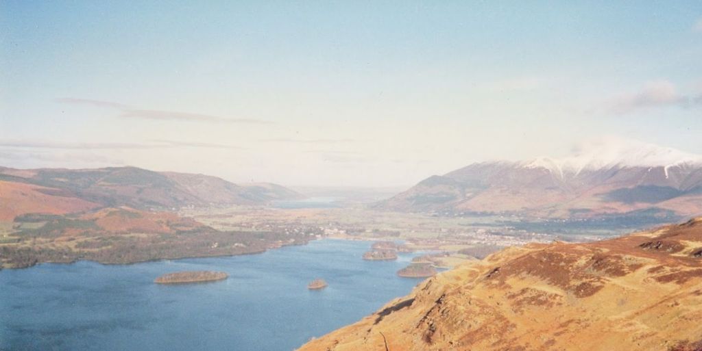
After Scafell Pike we stampeded back down to Narrowcove and then down the Corridor Route across this great mountain, to arrive at Styhead at 3.50pm. At Styhead three members of the party retreated down the pass direct to the cafe at Seathwaite. The rest of us did Great Gable. We were limber and ready for action, we were twenty years old. From Styhead to the summit of Great Gable in forty minutes, to find the top occupied by cragsmen. A highly recommendable view from here – the best bit probably the Buttermere valley and Crummock Water, and in the sun, Wasdale. [19/1/21 I think this was the occasion I took a picture of the view down into Wasdale. It was so good I had it enlarged and for many years a copy of it was framed on my mother’s wall. I was using a Zenit E SLR at the time.]
It would have been better still an hour later, at sunset, but we left the summit after a good rest, to descend the unpleasant steep slope to Windy Gap, to trample the red soil of Green Gable, and then down the steep path into Sour Milk Gill, the archetype of all hanging valleys. Off the hill at dark after an epic, classic hill-walking day.
13/10/85 Blencathra via Sharp Edge
Route: Blencathra via Scales Tarn and Sharp Edge, down to Threlkeld
Another large party of ten for a mass ascent of Blencathra! From the inn we moved along a road and struck left into a short valley, across the headwall of which, could be seen our path, forming a diagonal upwards. Mousthwaite Combe. At the top, we found ourselves on a broad whale-back, with a deep valley below. In it, the gloriously Tolkienesque River Glenderamackin. [Tolkienesque to me that is, not to the younger fellow who wrote this account in 1985; he knew nothing of Tolkien when he was 20.]
Along the left side of this valley, before climbing steeply up into the corrie of Scales Tarn. This is really impressive rock scenery, particularly Sharp Edge. One member of our party, somewhat afraid of heights and exposure, went up the screes to the summit. The rest of us went up Sharp Edge, with Karen and Rob at the front, and myself and Tim shepherding one or two less experienced walkers in the rear.
It was my first time here on what became and what remains probably my favourite route. I found it passably sharp, suitably impressive and very exposed, but too short. It looks a lot worse than it is from a long way off. When you think of the great ridge walks in the British Isles, the Sharp Edge of Blencathra is by no least among them but is certainly one of the shorter routes, only a couple of hundred yards if that. Crib Goch is only a few hundred yards of really sharp rock ridge mixed in with a mile or so of reasonably narrow ridge walking. For sustained narrow rock edge work you have to go to the Aonach Eagach above Glen Coe, which is miles long. But that’s not passable in winter conditions for walkers.
The route lies up over some gendarmes and up onto the summit where we had lunch. To the north there are many kilometres of wild moorland, but not particularly exciting hill country. At the top, it started to mist up. Blencathra has little to recommend it but Sharp Edge, and the descent was tedious in the extreme. This being a Sunday, had to be a short day – 4 hours on the hill. But satisfying for all that.
