Wild camping in the Lake District – October 2020
Part 1: To Windermere
I set off from Surrey around 3pm, starting a 300 mile drive in to the Lake District. Whilst without incident as a drive,there was very heavy rain in the Chilterns and then again around Stoke-on-Trent. The M6 Tollway I think highly of – belting along there cost me £6.90 and probably shortened my total journey time by six minutes. What price money? There are people – quite a lot of people judging by the emptiness of the toll road – who refuse to use it as a matter of principle. I confess I cannot get my head round that attitude. Arguing that you can’t afford it, for a one-off journey, cuts no ice. Commuting might be different, of course. Maybe they object to the principle of roads being private property rather than public infrastructure.
I got to my B&B in Windermere in heavy rain, a little after 8.30p.m. Mine host was a rather eccentric and somewhat peremptory older man. Eccentric, in that he’d already admitted (as a businessman and B&B owner) to not possessing a mobile phone. To not own a mobile phone in Britain today, is in my view little more than a fashion statement. Not owning one as a B&B owner indicates an indifference to customers that I don’t find encouraging. Peremptory, in his attitude. Breakfast was exactly 8a.m and appear here in the hall and I’ll show you into the dining room. (This beats by some margin the narrow window “breakfast is 8.30 til 9, any time” offered by a cheery Australian landlady in Weymouth, which became a standing joke in our house for years afterwards.) Always remember – Fawlty Towers was not a sit-com: it was hard-hitting documentary.
My room was a typical B&B room, woodchip on the walls, a sink, no en-suite, comfy bed, tea-making facilities. I went out for a rather dank pint in a local pub, and went to bed, to sleep well enough.
Part II: from Great Langdale to Styhead
Next morning I went down at exactly 8a.m and mine host was waiting for me. He showed me into an empty dining room set for over a dozen people. He served me as good a Full English as ever I’ve had, with a pot of the strongest and tastiest coffee I’ve drunk in years. An excellent start to the day. Before 8.30a.m I had left – through the misty moisty morning to the head of Great Langdale, where I parked the car in some flat land near the road, a mile or so beyond the Old Dungeon Ghyll Hotel. Getting my gear right took some time, and it was probably near enough 10a.m before I set off.
My rucsac had weighed 16kg at home before so much as a bite to eat went in it. Now, it must have been well over 20kg. I hadn’t walked thirty yards before I wondered if I needed to take a longer warm-up. I considered walking the length of Mickleden, nice and flat, but that meant the horror of climbing Rossett Gill at the end. I decided to stick with going up The Band, so off I went towards Stool End Farm. And as I climbed, I came across the true deliverable of physical fitness. This last six months I’ve been running 20km a week. I walked up The Band in an hour and forty minutes, carrying a 20kg rucsac. I don’t say I didn’t break sweat, nor that it didn’t take it out of me, but my pulse stayed under 100 all the way. Happy with that!! At the top, a rest before continuing up Bow Fell, which despite it’s daunting aspect I found a straightforward ascent. At the top it was almost noon and there was a squall coming, so I stopped for lunch.

From Bowfell I continued round the Scafell horseshoe. Ore Gap, Esk Pike, Esk Hause, but missing Great End. The weather was glorious, so I continued right on up to the summit of Scafell Pike itself, where I arrived at 4p.m.
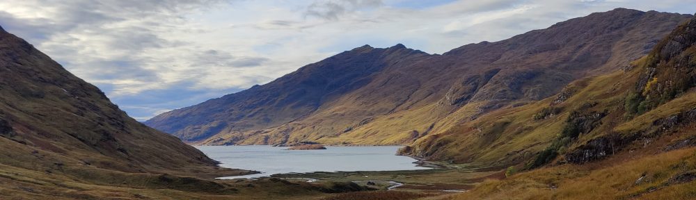
It was cold. On a few occasions I had cause for concern that I should have brought mittens – as well as gloves. From Scafell Pike back down to the col and down the Corridor Route, starting to feel tired. But what wonderful light: Here’s the view down into Wasdale:

At one point, in the pleasant later afternoon sunshine, the path went down some very steep and rocky ground. You can do without that, when carrying a 20kg expedition bag. In Frank Herbert’s novel “The Dragon in the sea“, an old and wise submariner says to a more junior officer, “As a submariner, you only make the same mistake once“. For me as a man in my fifties carrying a huge rucsac, descending a rocky scree or boulder field, that was true. Here, I would only slip or put my foot wrong once. There would be no second chance. Taking the greatest care one does get down, though the thigh muscles ache. One has to be in the position of being able to lower, in a controlled way, your entire body weight, just on one leg. You have to keep your centre of gravity behind you – if it gets in front of you, you’ll topple over in an instant and game over man, game over…
Very tired, I reached Sty Head, and opted to camp there, on flat ground by a babbling brook.

For supper I had fresh tortelini and some sausage, with onion, garlic and pesto. I use a very old and battered Trangia stove, the smaller “27” model. It has served me well for nearly 40 years. With this stove I feel rather like the proverbial man who has his father’s axe – I may have replaced some of the parts. On the hill I was munching through a small tiger loaf bought in Windermere, with Red Leicester cheese, butter, cherry tomatoes, and a satsuma. I was also using a trail mix of sultanas, raisins, seeds, salted peanuts and chocolate chips. This was inspired stuff – a mix of fast and slow energy. I learned this trick from a teacher when I was in school. And because I can afford the weight, a counsel of perfection for my evening meals was a bottle of Malbec, though wine and bottle weigh over a kilo. It’s an absolute fundamental to me that wild camping doesn’t mean rough or hard living. Camping doesn’t imply “roughing it”. Life offers enough difficulty as it is without adding further artificial complexity.
It was very cold overnight – an unpleasant cold breeze blew in through my air vents, til I shut them, at the expense of increased condensation. During the night the moon came out, which caused me some odd dreams and I did wake up briefly.
Part III: from Styhead to Buttermere – a round of Black Sail
My breakfast was porridge with a dash of Scotch, black coffee with a good deal of sugar, and a sausage. Breakfast of champions. Despite the cold and clear sunny morn, I had what was effectively a wet strike because of condensation. I shouldered my pack and set off towards the path. I passed a fellow out running with his dog, going in the Wasdale direction. It was about 9-ish. I reached the bottom of Aaron Slack and started up. The last time I was here, was twenty-odd years ago, coming off Great Gable with a friend of mine in absolutely dreadful weather: it was the time we met Todd, a lone American youth. Taaaarrrd, as he pronounced his own name, was rather over-equipped, we thought, at the time – probably August. I didn’t feel over-equipped now in October.
I was carrying an MSR Elixir 2 hike tent, an Alpkit three season down sleeping bag, a Thermarest mat, the smaller (size 27) Trangia and about a pint of fuel. A full set of spare clothes, a first aid kit, maps and compass, a hip flask, two litres of water, and food for two more days on the hill. Don’t forget the (hic) half a bottle of Malbec. And of course a pen-knife. And a small pair of field glasses. Waterproof trousers and jacket, fleece, scarf, gloves, wooly hat. And I carried that lot up to Windy Gap between Great Gable and Green Gable. And there, I met a chap with a dog. “Don’t I know you from somewhere?” I almost said. Sure enough, it was the same guy. In the time it had taken me to grind up Aaron Slack, he’d RUN up Great Gable and down the other side. And I thought I was fit. He had a friendly and well-mannered grey dog, which whilst I was sat down, came over to see me.
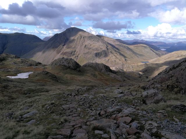
Just look at the view: Pillar is on the left there. Ennerdale centre, and Red Pike just right of centre. Crummock Water is visible to the right, and the coastal plain beyond all.

From Windy Gap onto Kirk Fell: my first navigational tactical error of the day. Staying high is always good advice when hillwalking, of course, particularly in such beautiful weather. I could descend all the way down to the Black Sail hut and then back up the Black Sail Pass to Pillar, or, I could stay high on Kirk Fell, but come down off the fell to the top of the Black Sail Pass. I could see on the map that the descent went through “Kirk Fell Crags” but I didn’t pay enough attention to the detail. Coming off Kirk Fell, I not even see how steep; the land dropped away. The path descends very steeply through rocks and screes. Indeed, no-one could come up that path without actually climbing or scrambling – and I must descend with that huge heavy rucsac.
Mixing down-climbing – descent face-in (making one feel very exposed, but much safer) and going down face-out (you can see where you’re going and you feel safer, but it’s always more hazardous and you’re more liable to slip) – I got down. I recalled advice about visiting the Black Cuillin of Skye. It was simple: if you’re not comfortable climbing downwards, don’t. Don’t go to the Black Cuillin. Down-climbing is a tricky technique to learn and you have to learn to trust your hands and feet. It is the better way down steep places, especially if the rock is wet and greasy. Here, all was dry. Had it been wet I would probably have turned back. Concentration and effort took their toll and I was morally shattered by the time I reached the col. Were it not even 11 o’clock in the morning I should have been tempted to reach for the hip flask for a swift steadying double. I resisted. Climbing onward toward Pillar, I was starting to feel a little jaded. I stopped for my lunch half way up at a “Pile of Stones”. Again, lovely scenery and such clear air.
At Pillar I needed to think: whilst there was no pressing rush, it was decision time about my further route and my final destination. Would it be Haycock and Steeple and then down, or would I go down from here, and then up and over into Buttermere or onto the Haystacks? I needed to start curving round and positioning myself to be within 4-5 hours walk of Great Langdale by nightfall. Here, the second tactical navigation error of the day. Instead of dropping directly off Pillar towards Ennerdale, I dropped down to Wind Gap, the next col, and down from there. The paths looked similar even on the 1:25000 map. But the valley route was the steeper and rockier, down into a deep corrie wherein, to my ears, were nesting some raucous birds of prey of some kind. A wild and little-visited spot for Lakeland.

Some way down, I found I had lost my fleece; it had fallen off my pack where it was strapped on. I dropped the bag and set off uphill in the sunshine to look for it. But how do you find a dark grey fleece on a boulder-strewn sunlit hillside? I had neither the time nor the energy. By mountaincraft and not by luck, there was nothing of any value in the pockets of the fleece – save for all my alcohol gel and a mask.
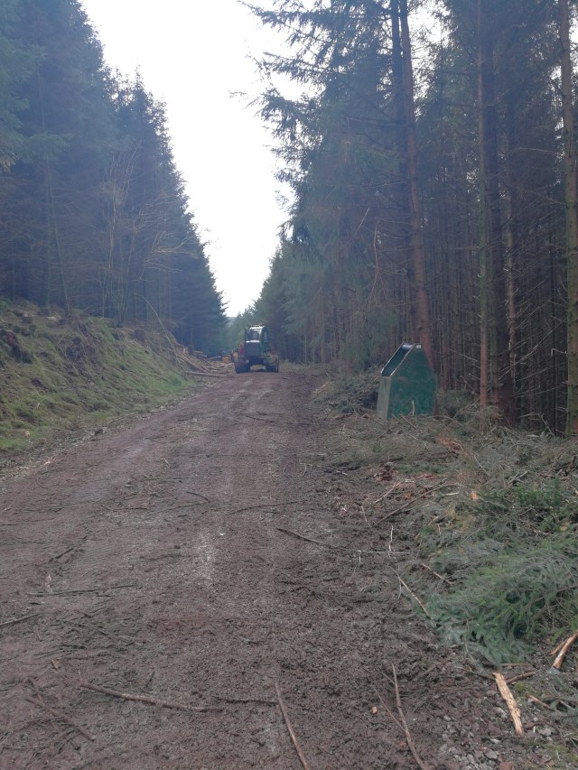
Downwards to the edge of the industrial forest of Ennerdale, crossing a stream on a fallen log, on through the dank moss-ridden woods. I do love a forest but this place made Fangorn look friendly. In the distance far below, orange. I emerged onto a forest road where three absolutely enormous tracked logging machines stood. This is a deeply industrial environment, in the heart of some beautiful countryside. Then, a long and tiresome five kilometre tramp uphill alond the forestry tracks to the Black Sail Hut.

After a brief snack of bread and cheese at Black Sail, my final climb of the day, through the Scarth Gap into Buttermere – this was familiar terrain. Down into Buttermere for supper and camp at dusk.


Part VI: Buttermere to Great Langdale by bus
I camped in a little dell by the lake. It was a warm night on the Buttermere valley floor – much warmer than up at Sty Head. The forecast rain started at 7a.m, so I had a full wet strike. My supper and my breakfast were the same as the night before – for supper, tortellini, with sausage and pesto, and for breakfast, black coffee, and porridge with chocolate chips and a dash of Malt Whiskey. Dalwhinnie, I think this was, though after being stored in a hip flask it might as well have been Grouse. The second half of the Malbec slipped down nicely and I did not begrudge carrying the extra 1.2kg. As I weigh 91kg, I feel I can afford it. Nor did I begrudge carrying 250g of butter, 200g of cheese, 400g or bread, or an onion. Camping wild and backpacking doesn’t imply living rough.
I walked out the mile or so to the Fish Hotel in light rain, and was very pleased to find a bus to Keswick leaving in half an hour! Just enough time for a quick latte in the absolutely excellent Syke Farm Tea Room. The bus was driven by an amiable scotsman who a number of times had to stop and grab a seat cushion which kept falling to the floor each time the bus went round a corner. It cost £6.40 and ambled through the rain along the shore of Crummock Water, before climbing over Whinlatter to Braithwaite and Keswick.
At Keswick what to me appeared to be luck continued: twenty minutes stood outside Booths in heavy rain and I was onto a big double decker, bus 555, for the journey over Dunmail Raise to Ambleside. Cost: £9.40. At Ambleside I got off a stop too early even that didn’t prevent me from catching bus 516 to the Old Dungeon Ghyll, cost: £6. My journey by road from Buttermere took barely three hours and cost £22. A private car couldn’t have made the journey in much less than half that time. I would have been ready – though perhaps not so happy – to have paid three or four times that amount for taxis.
Had I known that public transport in the Lake District was so comprehensive and so well co-ordinated, I would never have brought the car at all. From where I live in East Surrey, the train would be about the same journey time, maybe slightly quicker, and a good deal less tiresome than trudging up and down the M40 and the M6. The train might cost a good deal more than the cost of the fuel – but as any fule kno, the cost of fuel isn’t the true or full cost of motoring.
Back in Langdale, I swiftly changed into town clothes, under grey lowering skies and pouring rain, and retreated back to Ambleside.

