23/5/87 – Keswick to Buttermere via Crag Hill
I left Keswick at 4pm, wearing shorts, in warm summer sunshine. A pleasant enough road tramp down into the Newlands valley through Portinscale and onwards to Stair, seeing Catbells off to the left. I glimpsed the Lodore Swiss Hotel in Borrowdale through the trees at one point, distant grey slate. Eventually, in cooling late afternoon, I started the first uphill grind of this, my twenty-first visit to the Lake District. Upwards onto Causey Pike and thence onto Scar Crag and Crag Hill (2753′) and Whiteless Pike (2159′).
I encountered a number of people returning home, walking under the pastel skies of a late spring evening. But not too many people: seven people in six hours and ten miles of mountain traverse. Quiet for a Saturday in May in the Lake District. There was tremendous mountainscape, the skies a faded blue.
A low scale map and some indifferent map-reading led me into a few errors, but all was well in the end. Crag Hill is well named: there are grey crags on all sides, as if in defence. By the time I reached Crag Hill it was getting cooler, I was getting lonelier still on the high tops on a Saturday evening, and also, I was getting hungry. I hurried on, finding it difficult to lose height.
Eventually, after long descent, the Buttermere valley lay before me after six hours on the hill through the quiet of the evening. I went to the Bridge Hotel for supper.
24/5/87 Buttermere to Great Langdale over Red Pike, Haystacks and Green Gable
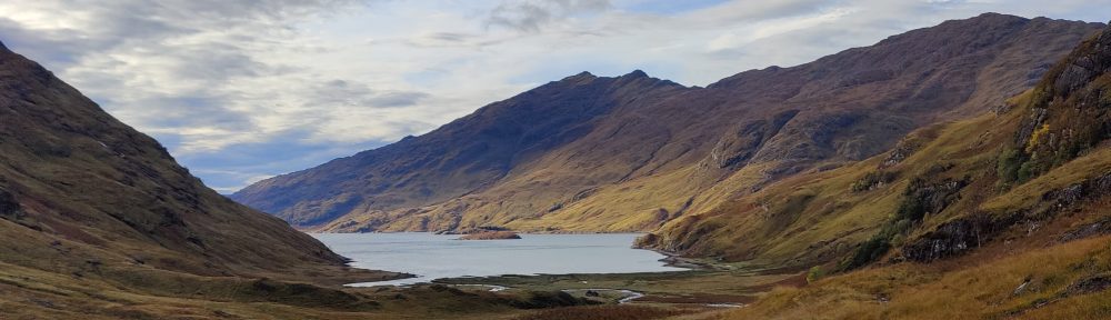
Feeling a little stiff and sore, I trod across the Buttermere valley floor under clear skies, and started the slog upwards through the woods by Sour Milk Gill. It was seven years since my last visit here. The trees give way eventually to open hillside and the valley disappears into the haze. The path winds its way into the corrie containing Bleaberry Tarn. Here, there was complete stillness and utter silence – an absolute cathedral of beauty, silent but alive. From here, another long climb up onto Red Pike (2479′). This was very steep and quite dusty – as with the walk through the Derwent fells yesterday. The Lakes are very dry this year.
At the top I rested, before thundering along the ridge to High Stile (2644′) and High Crag (2443′). From up here the Buttermere valley was looking very alpine. On the right, Ennerdale and the towering flanks of Pillar. Tremendous hillwaking – up and down and along, alone, savouring the weather, the clean air, the mountain scenery, the crags and gullies.
A steep and dusty descent to the Scarth Gap, the lowest altitude of my day, which I reached after three hours on the hill. Ennerdale and her trees were dwarfed by Pillar. Great Gable was a dark mass to the south-east. At Scarth Gap I had a brief snack before pushing on, with dwindling water supply, towards Haystacks. There was some good scrambling to be had here. The top of Haystacks was crowded. I searched for running water, finding only still and stagnant pools. I was forced to go down to Blackbeck Tarn, itself almost stagnant, to refill my water bottle. I was glad of purifying tablets.
It was after 3pm when I continued over less frequented brown moorland towards Brandreth. From where I was stood on the summit of Brandreth the view back was of both Buttermere and Ennerdale, like spokes of a wheel, with visibility all the way down to the sea. Still far off in the distance, the high notch of Windy Gap could be seen between Great Gable and Green Gable: Through that notch, I must perforce go, later this afternoon. As I approached it, the blank face of Great Gable resolved into cliffs and screes. This walk, already long, was developing into a rare classic. I was hoping to cover a distance similar to a hike I’d done with R.C.E Ball some years back, and as such, my tentative – and ambitious – destination was Great Langdale.
I said to myself, if I reach Angle Tarn after 7pm, I’ll pitch camp there. I arrived on the summit of Green Gable at 5pm. Already the mountains were noticeably quieter – many folks had already gone home. At Windy Gap I eschewed visiting the summit of Great Gable, and started dropping down the dust and screes of Aaron Slack, down to Sty Head. From there, noticing a number of campers at the tarn, I moved up to Sprinkling Tarn, which I found to be an unbelievably crisp blue, reflecting the evening sky. Filling up again with water, I moved on past Great End, noting that there was still snow in Central Gully. The last time I came to the Lakes I was on Great End.
Onwards through the evening up to Esk Hause, taking a snack there before going on downhill to Angle Tarn. [22/1/26 this was a significant and unnecessary uphill detour, going up to Esk Hause.] It looked inviting, it really did, but I decided to press on. More food and drink, for I was tiring now, and had ahead of me the God-awful tricky descent of Rossett Gill, difficult at any time but doubly so when carrying a big rucksack.
Then, along the quiet of Mickleden, my shoulders and my feet screaming, a stitch in my tummy, towards the Old Dungeon Ghyll Hotel, at which to end one of the longest and most satisfying days on the hill I have ever had. I camped at the National Trust site.
25/5/87 Pavey Ark via Jack’s Rake and onwards over High Raise to Borrowdale
The weather broke. Under clouds, expecting rain, I trod up the staircase-like footpath up Stickle Gill, only mildly exerted after two long days on the hill. I had been anticipating an ascent of Jack’s Rake for some years and was looking forward to this. Jack’s Rake forms a top left to bottom right diagonal slash across the face of Pavey Ark. Could I get up it carrying a big expedition bag?
By no means alone even on this Bank Holiday Monday morning I addressed myself to the climb. It is an enclosed, sheltered and not over-exposed easy rock climb or scramble. Only once on the route did my rucksack come close to impeding my balance enough to worry me. The route is obvious throughout, well trod and hence heavily scratched by hobnail boots for decades until Vibram soles became common in the 1950’s. It is wet – Jack’s Rake is formed by a drainage channel across the cliff. There is more fun – depending on your viewpoint – nearer the top.
From the summit, over open and featureless moorland, gentle slopes leading to High Raise (2500′). This is a wilder, less well-trod part of the Lakes and I was alone here. There are strange views. Glaramara, and the head of Langstrath could be seen to the left, looking very wild. I decided to drop down into Borrowdale, and headed for Greenup Gill. One drops sharply down, the path following the back of a textbook “esker”. All around this area of the Lake District are textbook glacial landforms – eskers, drumlins, hanging valleys etc.
Downwards into Langstrath – the long valley – and ultimately thence to Rosthwaite, Borrowdale. By the time I arrived there I was tired and worn, particularly my feet, and was well content to clamber aboard the bus to Keswick, at around 2.40p.m.
