I took train to Crewe, arriving in good time for the sleeper service to Scotland. The train slipped into the platform almost in silence, as if to not disturb the sleeping customers. I boarded, and off we went. In the morning the train stopped for a while at Tarbet on Loch Lomond-side. I could hear the rain drumming on the roof of the carriage – but that was at least forecast. I was allowed by the male provodnik (Russian for “sleeping car attendant”) into the “Club Car” for my breakfast, and told somewhat loftily to sit “over there” clearly away from the very few first class customers. Feeling less than welcome, I had my sausage bap and cup of tea, and left.
At Bridge of Orchy I got off, and under the shelter of the station canopy, prepared for hiking. It was raining. The buildings of the station have been converted into a low-cost hostel, although I saw on social media that this hostel has a poor reputation as being somewhat spartan. The West Highland Way, or proximity to it, is an opportunity to sell excellent services to travelers, or perhaps, in some cases, a magnet to less scrupulous property owners hoping to make a fast buck from accommodation. The railway station itself is uncrewed – as was the hostel, at this time of year.
I left, in the dripping rain, and almost immediately passed the only southbound hiker I saw in two full days on the hill. It was 9.a.m. The initial part of the route lies over the summit of Mam Carriagh and is marked on the OS map as an “Old military road”. It is one of General Wade’s roads from the early eighteenth century, from the years of the Jacobite rebellions. As I walked, the rain rose to a crescendo, and I made full use of my new Mountain Equipment “Lhotse” jacket, which I bought heavily discounted from Cotswold. It is has a great hood, but as a tall man I could do with a waterproof least six inches longer in the body – a coat in fact, not a jacket. Why are modern mountaineering waterproofs all jackets?
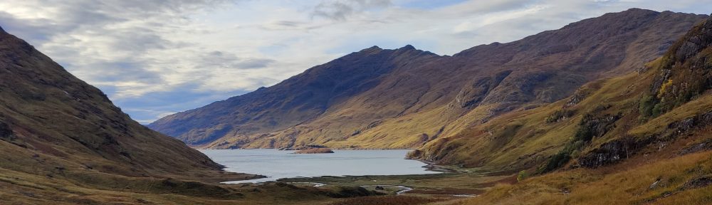
I came down to the Inveroran Hotel, all shuttered up now for the winter, in grey and spitting rain. Onwards onto what was referred to on a sign as the “Old Drovers Road” to Glencoe, which was ostensibly the main road before 1933 when the current road was opened. Of the current road, arrow-straight across Rannoch Moor and with sweeping curves down through Glencoe, the Scots mountaineer W.H Murray once said (a propos of complaints that it spoilt the landscape) that the new Glencoe road could “no more spoil the landscape than the facade of Chartres Cathedral could be damaged with a pen-knife”. Murray was quite right – and he was an early environmentalist.
There is no evidence that this road was ever covered in tarmac – it is stones and cobbles now. Ninety years is a long time; the tarmac could be long gone, but I somehow doubt it ever was a tarmac road. I found the road very hard on my feet, but that may be because my current boots are approaching the end of the natural life and may in consequence be a little thin in the sole. But it is a good road, passable by car even today (were it allowed – of course it is not), albeit at not much faster than 10mph. It rises gently from Victoria Bridge at 174m to a summit of 353m over 7km, before falling again down to the access to the “Glencoe Mountain Resort”.
Is there a sport less sustainable than skiing? I am a mountaineer. I seek to cross mountains for pleasure, doing so on foot, doing so safely, and leaving no trace other than footprints. There are few things I find much more depressing than a ski resort in off-season. (Maybe a British seaside town in February…) A ski resort needs good roads, ski lifts, hotels and shops, bars and restaurants, accommodation for staff. It needs street lighting, drainage and all the other municipal services we take for granted. All these things are good things of themselves. But out here in the beautiful autumnal brown of the Blackmount in November, I find it all rather jarring. Even as I stood by the roadside thinking this, a 32 tonne truck rumbled past carrying a snow-mobile and ski-lift pods. I finish where I started: can there be a sport less sustainable than skiing?
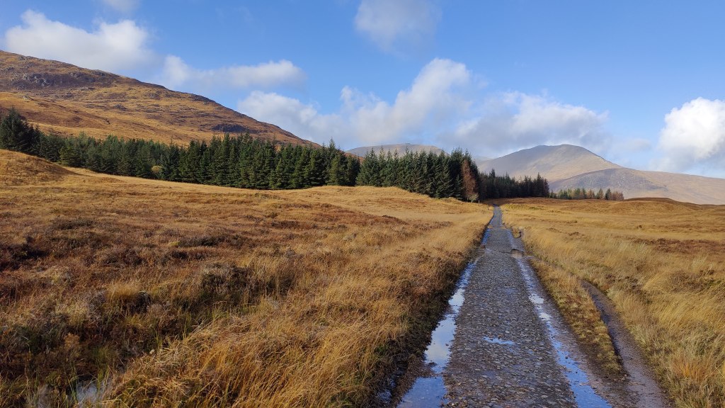
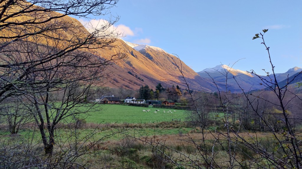
Crossing the A82 as quickly as possible, but with great care, I continued. From here to the Kingshouse the way leads along what is clearly a former tarmac road. The Kingshouse, once merely a hotel, is now a small community. One day, it seems to me, it may be an actual village called “Kingshouse” – there are diverse lodgings and houses, and a community centre, as well as the eponymous and famous hotel with its extensive car park. It even had a roundabout. In the car park I had to detour round tourists taking photographs of a red deer which had wandered in. The weather was darkening.
A hundred yards past the hotel, once again in open country, I decided to stop for a snack. My mountaincraft is sharper and better than I know; it works at a subconscious level. I had barely finished my chocolate and so forth, when a squall of rain and hail descended. I was hard put to get my hat, gloves and scarf sorted and my coat zipped up before the onslaught. How had I known that the squall was so imminent? How did I know to take this last opportunity for a snack for an hour or more? It was surely neither luck nor coincidence.
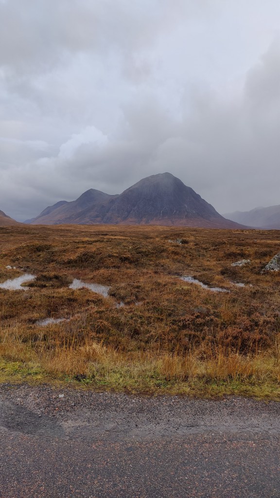
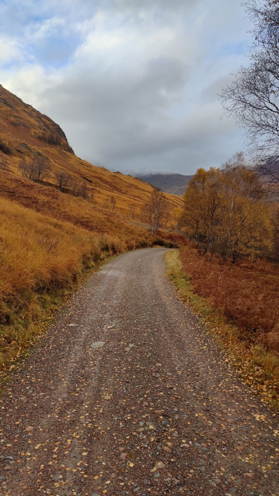
The next stretch of the road was again an “old military road” more or less parallel to the A82, finishing at Altnafeadh. The weather was dreadful; grey cloud and squall, brash wind and rain. I would have taken more pictures of the magnificent towers of Stob Dearg (“Buchaille Etive Mor”) on my left – perhaps the most recognized mountain in the UK. But others have photographed that graceful hill more effectively than I, and I was loth to take off my gloves in this rain.
At Altnafeadh it was 3pm. The traffic rushed past; the clouds lowered. Time-wise I was on target. I had thought I might camp here, having at very best maybe ninety minutes of daylight remaining, and not wishing to be caught in the hills above the Devils Staircase. But there was no suitable location, and the rain came down. I had a little snack and a fat little robin came and sat near me; I fed it with some of my wife’s Rice Krispy cake. Onwards: in heavy rain and hail I started up the Devils Staircase. A struggle if you’re not fit, that ascent, but I pushed very hard and fast uphill, to the point of starting to overheat. Time was of the essence now. I had to find a flat and sheltered place in the hills to pitch my tent, and I had to do so pretty much within the hour.
I thought, looking at the wind direction (this is mountaincraft again) that the weather would be better on the far side of the hill up which the Devils Staircase goes back and forth. I was right to think that; so it proved. On the Rannoch/Glencoe side, grey rain, clag and wind, hail and storm. On the far side, calmer, even to some blue sky. I pushed on over as late afternoon became evening and dusk, looking for a camp ground. I had limited daylight and my salutory experience in the Cairngorms two years ago was fresh in my mind. I found a flat place right next to the trail, right next to a stream. Not a place I’d choose in summer. The place was more or less where I had predicted from theory beforehand that I ought to camp, in order to make this passage from Bridge of Orchy a two-day rather than three-day hike. It was the stream of Alt a’ Choire odhair bhig.
My tent went up easily enough, pitched outer first as rain looked imminent. In fact I had not long been pitched when there was a tremendous hailstorm turning the world white. I found it hard to get warm, but once I’d eaten and gotten into bed, I warmed up in due course and slept passably well, being in bed for nearly 12 hours.
I awoke respectably late, but still before dawn. Surprisingly so given that I had been in bed for almost 12 hours. I went through the drill of having breakfast (porridge with an admixture of chocolate, sugar and sultanas and a little malt whiskey) and striking camp. The practice of solo backpacking and wild camping, particularly in autumn or winter conditions, is the practice of detail, the practice of method, the practice of doing things right, in the right order. In other words, it is the practice of mountaincraft. This is one of the reasons why I put myself through it. It is no ordeal; it is a pleasure and a privilege. It is a pleasure and a privilege to be alone in the wild. I can put myself, in an uncontrived way, in a place where doing things right, in the right order, is the difference between, on the one hand, an enjoyable and relaxing experience, and on the other, a dreadful or even life-threatening experience.
I was on the hill, full of breakfast, by 8a.m. I had a long day ahead of me of 32km, but I knew I could make Fort William, if not by nightfall (about 5pm) certainly not much later. I started out in Gore-tex over-trousers but today’s weather was much more forgiving and they soon came off on the descent to Kinlochleven. Early on, I had problems with very cold fingers, as my gloves were wet from the previous day. I had to use my big mittens, which were still dry. One action from this trip is that I need to think carefully about carrying multiple pairs of gloves (as one carries multiple pairs of socks), or, look into waterproof gloves. The light and the views this morning were lovely.
Coming down into Kinlochleven one sees six tremendous pipes marching across the landscape, bearing water from the faraway dam on the Blackwater Reservoir. At the bottom of the hill by the river, an enormous and striking mill, Edwardian architecture with some Edwardian technology inside and out, as the rushing water from the great pipes feed the hydroelectric plant inside. Kinlochleven at 9a.m was quiet and cold, only dog walkers were around. I’d been aware that I could have resupplied here to save weight, but it turned out that I needed nothing, and I walked on out of town without stopping. Kinlochleven is rather sleepy and forgotten since the opening of the Ballachulish Bridge in 1975. Today it seems little more than the start of the final stage of the West Highland Way. That said, its location is stupendously beautiful, central to a wide range of wild country and high mountains. It reminded me, however – particularly in cloud-streaked autumn at that time of day, of the town in the Pacific Northwest in Sylvester Stallone’s film “First Blood”.
I climbed up out of town through pleasant and fragrant managed pine woods, emerging into a higher, colder valley. “Footpath to Fort William via the Lairig” the sign had said. The path runs true up the right hand side of the valley, reaching a bealach at which there is a substantial ruined house. From here, one cannot see where the route goes, but it curves round to the right and to the north. I passed a young woman out from Kinlochleven; she said she was just doing this last stage. Only the second person I had seen hiking for two days.

The path continues northward, a little open on the left, with higher mountains on the right. Such trees as there were in the area were not entirely consistent with their representation on the map – this is a working plantation. I had been saying to myself, “Ben Nevis dominates Fort William, but I cannot see it yet. When will I see it, and know that I am getting closer to my destination?” The path kinks round to the right, trending more north-westerly, and finally, in the afternoon, I found myself in a place where I knew that just beyond, lay Glen Nevis. At the head of this valley was a confusion of hillside, rather strange looking. Some odd geological effects were at work here. In the heart of the confusion, lies the ancient fort “Dun Deadail”.

From Dun Deadail, the way lies along forest road all the way down to tarmac in Glen Nevis. In the deepening cold of late afternoon (that is, 3pm at this latitude and time of year – it’s great to come to Fort William in May when “late afternoon”, from the perspective of the sunshine, is 8.30p.m!!) I trod the forest road down, and then tramped the final tough tarmac mile or so into Fort William.
In Fort William I was met by a friend of mine who kindly arranged for me to stay at the excellent Fassfern guest house on the shores of Loch Linnhe. We had a couple of pints and some pizza at the Black Isle pizza bar in town, but to be honest, after my trek I was shattered, and was glad to be in bed by 9.30pm.
A ten-hour train journey
This first leg of the immense train journey back to the English midlands leads through a brown, grey and relict green autumn landscape, towards Spean Bridge. In the distance, cloud-draped mountains have winter’s first coat of snow. Behind me in the tiny two-carriage train, are five mums with at least that many toddlers, dogs, bicycles and pushchairs, all off on a short winter’s day’s outing to Corrour. The toddlers are all of a gurgle; at my feet, one of the dogs has settled down to hide from the youngsters. The train wends its way along a gorge; the frothing river is the colour of Guinness being poured. You can hear the engines straining as the train climbs the grade up onto the moor. I could be on worse train journeys and I probably will be later today.
Crianlarich: nearly two hours out from Fort William. It would take an hour to drive here from Fort William, though to be fair to the train, it does take that huge detour up to Spean Bridge. As someone with a passing interest in railways it is interesting to note that some of these Highland stations still retain a substantial yard with sidings. Generally these are used, on this remote single-track railway, to store modern permanent way repair equipment. In England, many of these yards have long since been converted into car parks, particularly in the metro area where commuters dominate the market. This little train dates from the late 1980’s, and the technology in it is much older than that. Hearing the sound of the antique brakes, though I’m sure they are perfectly good brakes, makes me feel about 12, so much does the sound remind me of 1970’s trains.
At Queen Street station in Glasgow, a delightful Victorian arched train shed, I join a brand-new electric train to Edinburgh. The Scots at least, have a constructive view on railway electrification: that is, do as much as possible, as soon as possible. I have a sneaking suspicion, however, that English tax-payers will be picking up the tab for it, even if the Westminster government and the Department for Transport feels it can’t afford the same for England. Who needs joined up thinking? I read that these new and shiny 21st century trains are actually owned by a Japanese bank.(https://en.wikipedia.org/wiki/British_Rail_Class_385). Another piece of evidence of the chronic short-termism of the people who manage and finance our railways.
Arriving at Waverley station in Edinburgh, I had to make a decision quickly. I had a seat booked on the 1707 X-Country service straight through to Derby. It was cancelled. The time was 1636. I might travel at 1710 down the east coast route towards Kings X, and change at Newark, and then across to Derby. Or, I might travel at 1652 down the west coast towards Euston, and change at Crewe, and then across to Derby. Which is better? Six of one and a half dozen of the other…or is it? this is advanced travel knowledge. I opted for the latter and joined an Avanti West Coast Pendolino bound for Euston. That was a good decision. As I’d opted for a very reasonably priced first class ticket, I got a nice panini and at least two Gins and Tonic, thrown in. That enlivened my journey to my home, which took until nearly 10.30p.m. That said, I left Edinburgh at 5pm and arrived at Derby about 9.30p.m, and that involving a change of trains. You’ll nae be driving from Edinburgh to Derby at that time of day, or at any time of day in fact, in four and a half hours.

Pingback: Have we in the UK reached “peak infrastructure”? | Plateroom 28