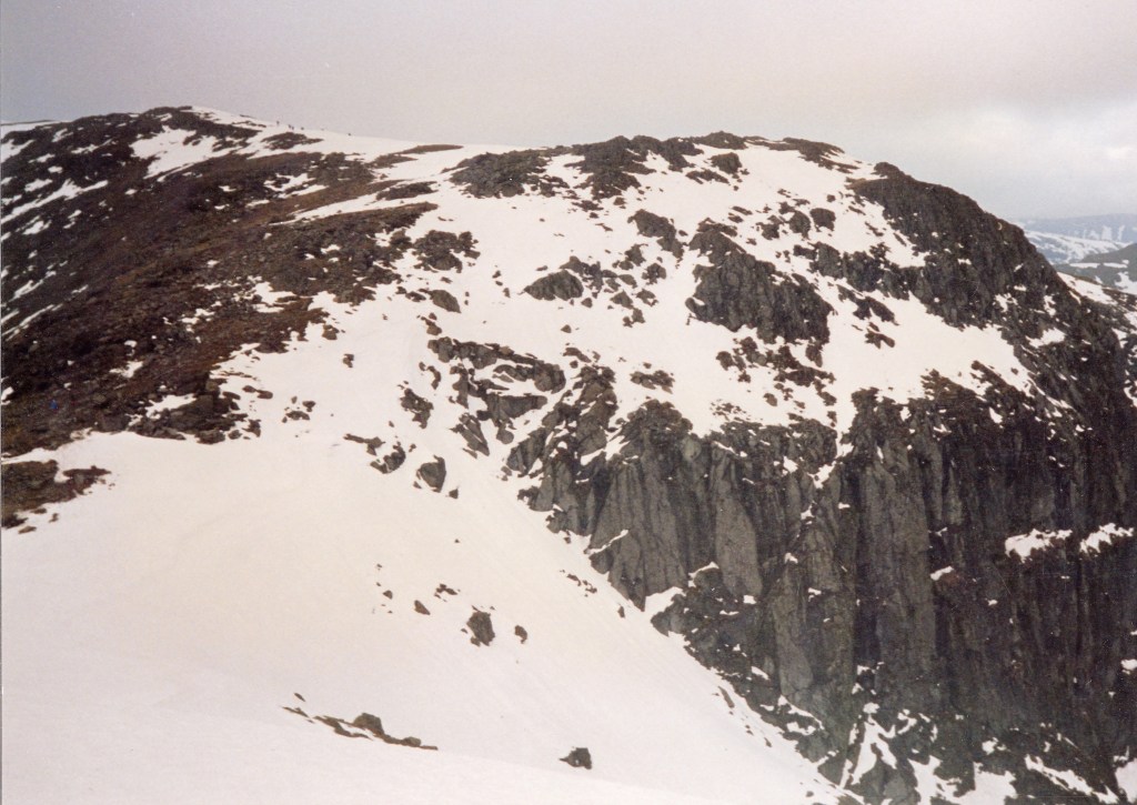
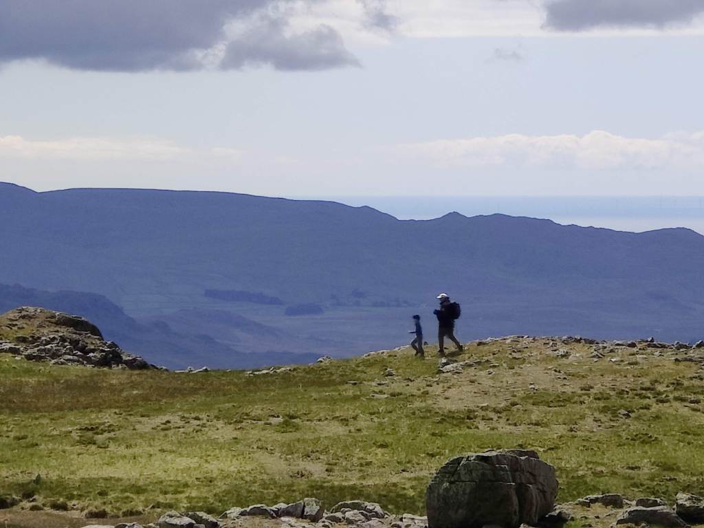
In cold grey clag we set off up Stickle Beck, intending at the least to visit Stickle Tarn, but both of us, I think – though neither of us said it out loud – intending to try for Jack’s Rake. We arrived at the tarn and had a short snack. Some young people were there; the mist was thick and cold. We walked round the side of Stickle Tarn and addressed ourselves to Jack’s Rake. This would be my fourth ascent of Jack’s Rake. I came up here alone, carrying a big bag, in May 1987. I led a party of four up in September 1989, and I brought my son up here in 2014. That took some coaxing and encouragement. I happened to mention to him the principle in scrambling and rock climbing that “hesitate and you’re lost” and he replied that he’d learned that principle from me, on this route.
I write that deliberately, for today, Jack’s Rake was cold and wet and I found it quite difficult – I was “sketched out” as my son might say; in places it was sketchy. Whilst at least the exposure was limited today because of the mist, my fingers, even in gloves, grew very cold. In several places I was stuck for some minutes, hesitating long before committing to upward moves. In wet and greasy conditions underfoot, one wants good handholds. They are generally there on an easy scramble like Jack’s Rake, but in wet gloves I was starting to loose feeling in my fingertips. Loss of handhold would have been catastrophic, whereas slipping and losing a foothold whilst retaining a good handhold, would merely have made my pulse shoot up. We got to the top in good order without really serious difficulty, me going ahead of Nat for my safe-keeping, he herding me up the route whereas on the previous occasion, our roles were reversed. This was fitting. I am not unhappy to say that I have probably gone up Jack’s Rake for the last time. It would have to be a dry summer before I venture back there.
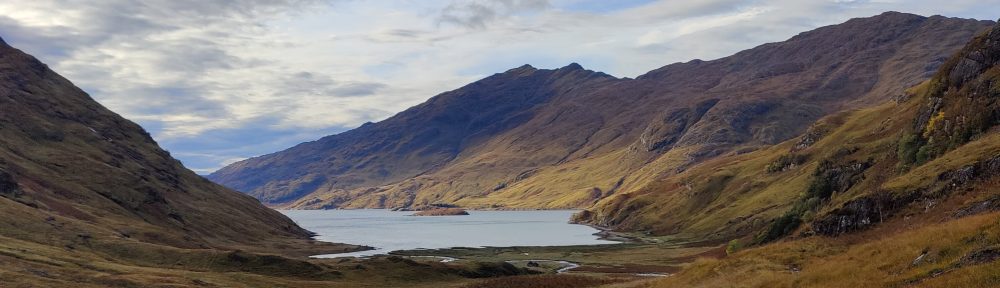
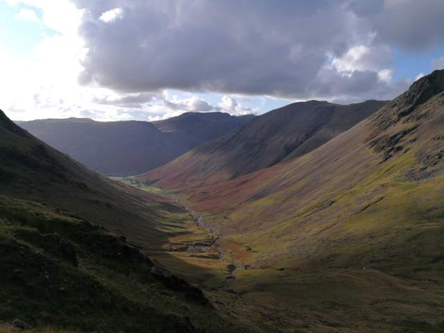
At the top, a short snack, before continuing by compass bearing through cold wind over cloud-strewn brown moor, overblown with rotten snow, down to the top of the Stake Pass. Down the Stake Pass into Mickleden, that most favoured of places, and along the valley of Mickleden in the slowly fading light of a winter afternoon. Even in winter I can’t walk through Mickleden without hearing sheep, without feeling the heat of summer sun on my shoulders. Then, tea for two in the bar of the Old Dungeon Ghyll, before a companionable wander through the gloom across the fields to the car park at the New Dungeon Ghyll. For a short day, a towering achievement. A good scramble, easy fellowship and safe transit over the mountains in poor weather.
I’m off on my adventures again, fitter, more experienced, and with a better packed rucksack and better equipment, than when I started doing this in the autumn of 2020. This is my fifth consecutive Autumn solo backpacking trip.
First, a trip from my home in the Midlands, to the Lake District, using only public transport. A flawless train journey; change at Sheffield and Manchester. At Sheffield, cloudless skies and sunshine. Barely ten miles later, emerging from Totley Tunnel into the Peak District, it’s grey cloud and drizzle all round. At Manchester, I changed into a shiny new “Transpennine Express” train going to Glasgow. I had thought that the very useful direct trains between Manchester and Glasgow were one of the many good things that had disappeared when the railways were privatised thirty years ago.
At Penrith, I stood sheltering from the drizzle waiting for the bus to Keswick. Here’s a father and his daughter travelling to the Lakes for half-term. Here’s a young English fisherman and his Eastern European female partner, with so much luggage you’d think they were actually moving to the Lake District. Here’s a bearded Italian traveller playing some kind of woodwind instrument, and here are five nervous-looking youths, Hasidic Jews wearing yarmulks, travelling to Scales near Threlkeld. A Monday on a bus in an English country town.
At Keswick, I stepped off the bus into light rain. I had planned to go by bus through to Braithwaite, but I needed to stretch my legs and warm up a bit so I thought I’d walk. I walked along a familiar route, past the Pencil Museum, across the muddy wet fields to a suspension bridge, and on to Portinscale. I first came this way in the late 1970’s. The path was flooded out completely – this Autumn the Lakes are very wet. At Portinscale I saw one of those micro-vans selling cakes and coffee. The young man running the stall had a little hand-written sign: “Mince pies £4. Free glass of mulled wine”. You can hardly ignore an offer like that…I had a chat with the fellow while I toasted my forthcoming adventure in mulled wine, and then moved on.
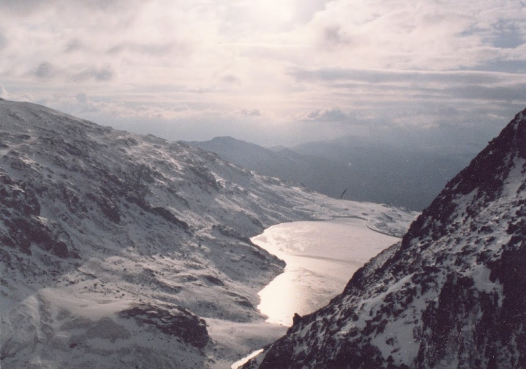
I followed a muddy path through the fields, cutting off a bend in the road, and still arrived at Braithwaite before 2pm, over an hour earlier than I’d planned. I’ve been coming to Braithwaite for over forty years, though I don’t think I’ve ever been here in fine summer weather. To me it’s a cold weather kind of place. I continued onwards and upwards towards Force Crag Mine, walking slowly. A temptation for the amateur athlete is to go too fast, too soon – and here, not only was there no hurry, but there was nowhere to camp except in a location barely two hours walk from here. At the mine, there is a turn-off to the left that crosses the stream and then curves around the hillside up to a distant cloud-shrouded col. There was a ford, and it was by no means passable, certainly not when walking alone with an 18kg rucksack. That was unlooked for. It was not in the risk assessment. I wasn’t expecting that. To have difficulty fording streams – in the Cairngorms, yes, one expects that. In the Lakes, even in October, not so much. It is very wet this year.
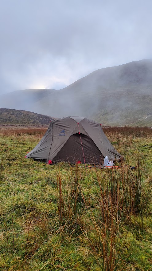
I continued up the right bank of the stream, through stones and rubble, through mud and marsh, through the outflows of strange settling tanks relating to the long-closed Force Crag Mine. I walked past the whole mine workings looking for a safe place to cross. At one point I found myself on very loose and spongy vegetation, quite possibly grown over a bog or an actual pond. Potentially lethal! I made a swift retreat. Force Crag Mine was a barytes, lead and zinc mine until less than forty years ago. It is in a beautiful location at the head of Coledale, with the dramatic Force Crag behind it. Eventually I managed to cross the stream, and had to bound uphill over steep heather to regain the path. Onwards up to the col and in no time at all I found myself a reasonably flat if not dry place to pitch my tent in the area above Force Crag. An eldritch, wild location, particularly as darkness fell. I made a good camp, had a good supper of fresh tortellini and red wine, and slept very well.
My camp above Force Crag
29/10/24
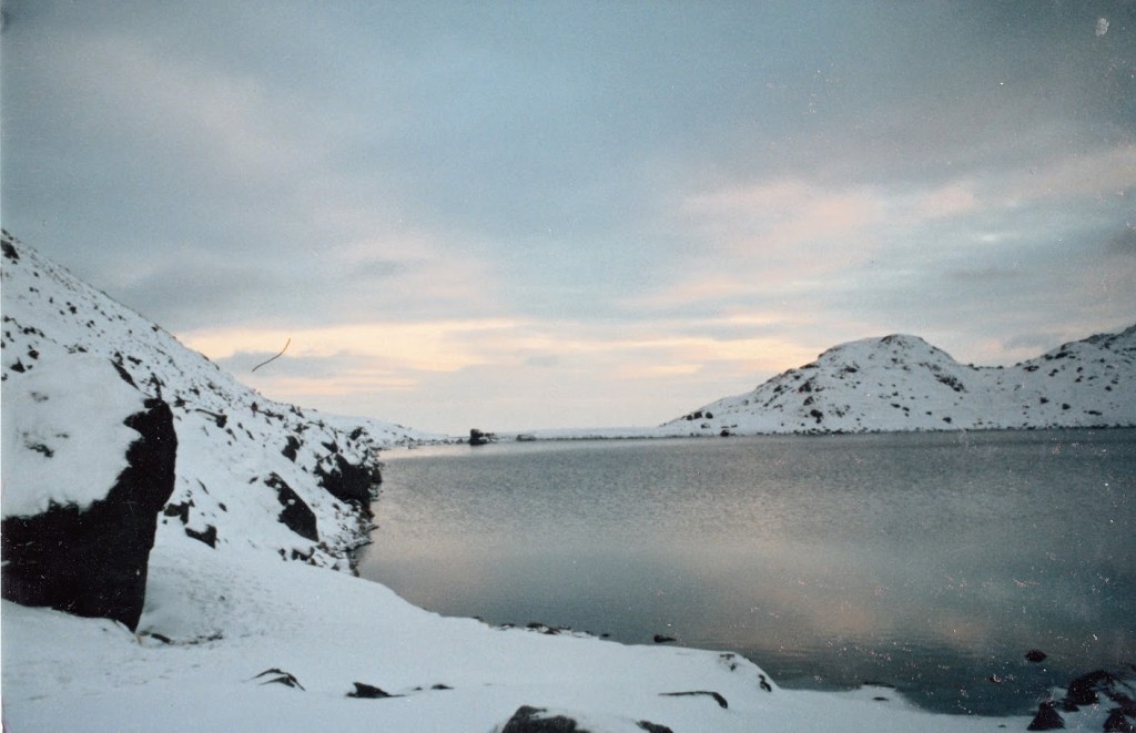
I was away from camp by 0745. It has taken me around an hour and fifty minutes from the decision to get up, to actually starting my hike timer. Unfortunately I had a wet strike – my tent was wet with dew and mist. My new Ledlenser lantern was superb, a revelation in kit. Light, small, and very bright. I walked first up through the clag to the windswept Coledale Hause – no real camping there; no water, no shelter. From Coledale Hause, to the left and south, up a broad valley to a crossroads (or crosspaths) at a gentle col. Here, turn right and uphill to Grasmoor, a tall hill (853m) whose rocky edges, such as they are, are away on the north side. Descending from Grasmoor, in thick mist, I had to resort to the compass and micro-navigation. This underlined an important principle of mountaincraft – trust the compass and not your inclination. (This does presume that you do know how to use a compass properly.) I counted paces and found where I needed to go. I would have liked to make greater use of my polythene 1:40k map from Harveys, but my path lay off the western edge of this map, and to be honest a 1:40000 map is neither use nor ornament for close navigation on foot.
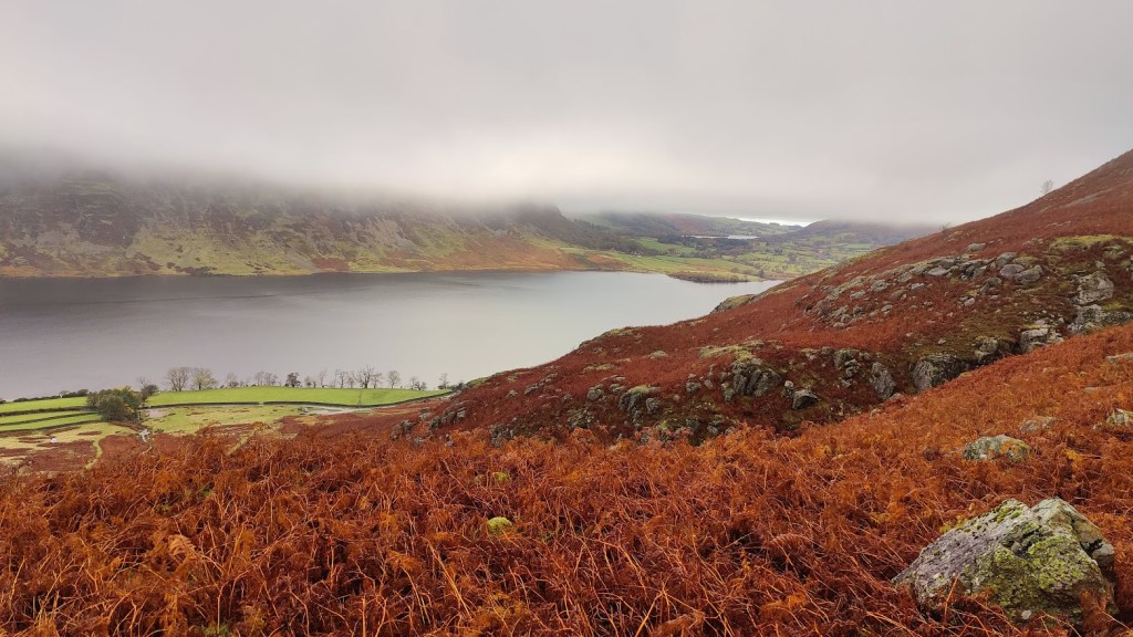
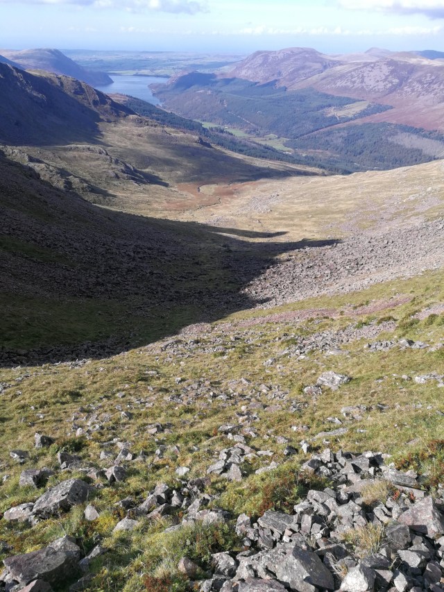
The path goes south and down the ridge called Lad Hows. At the start of the descent I happened to look round; as the clouds were thinning and sunshine was trying to peep through, I saw a remarkable sight. I saw a rainbow almost full circle, surrounding the mountaintop. I struggled to get my camera out in time; by the time I had it ready, the effect had almost disappeared. Further down, I saw a red grouse in silhouette against the cloud. It flew off. I pressed on downwards, eventually coming down below the cloud deck and seeing Crummock Water far below. I could see Loweswater, and also a distant band of light indicating that the weather was not quite as bad at the coast as it was here in the mountains. At the ford by the road I met the first of many half-term holidaymakers.
Descending to Crummock Water
Along the road for a few hundred yards, then left onto a parallel track. I was passed by two running ladies. This path was not on the map. The Ordnance Survey maps, whether 1:50000 or 1:25000, are wholly inaccurate and inadequate at this location. My route took me – this was not on the map at all – along a good path down the side of a woods (High Woods) to a stile where one enters those woods. Here I was passed again by the same two running ladies, this time going in the opposite direction. Clearly there was some kind of loop path not on the OS map. Interesting to see that the open-source maps available on the Ordnance Survey phone app, did have these paths. Onwards through some magical woods, past a boathouse. I met quite a few people and various dogs. The path led to the outflow of the lake, which is a modest dam – more of a weir, really – into which fish ladders have been built. On the other side of the dam, on a silvery grey beach, I found a place to sit for an early lunch. It was a little after 11a.m. I needed to charge my Garmin watch, which suffers serious power drain when recording a hike.
Looking up Crummock Water towards Rannerdale Knotts, the prominent mountain
I had the usual lunch: hard-boiled egg, chorizo, cheese, butter, tomato, and some pitta bread. Pitta bread was not a success when cold. Also, mini oranges and trail mix – raisins and chocolate and my own chocolate covered date/nut/seed fingers. A lot of holidaymakers passed me with a succession of labradors. Most of these were leashed or reasonably polite but one of them had to be physically restrained – actually man-handled – to keep it from sticking its nose in my bag of food. The owner’s very apologetic teenage grand-daughter, in charge of the dog (which was off-leash) was not strong enough to control it, and she was horrified by its behaviour. To those who might say that I presented temptation to the dog by having a food bag out, I say the same thing as I said to the dog…
After lunch, the path led quite literally along the water’s edge, past a pretty “pump house” (why are municipal water works in the UK almost always architecturally admirable?), and then away from the lakeside up over a hillside. I passed two black horses. Up through some more delightful woods – this was your Green Wood and Flass Wood, above High Park and Low Park farms – round the shoulder of White Crag. The path curved around to the left and south and on into Mosedale. Here in Mosedale I consciously and deliberately put in the pace, faced with the conviction that I was running late. The route up Mosedale is along a good un-made road. Later, the road ends and the path curves right and to the east, over boggy wet ground, towards Floutern Tarn.
Floutern Tarn was in the clouds, shrouded in mist and clag, and I was tired. At a rough col above the tarn, there was a straight fence marching up the mountainside. Where man can put a fence, I can walk. Oddly there was no path on the OS map, yet, today’s route, made months ago using the “snap to path” functionality in the OS mapping software, goes vaulting right up this mountainside – Steel Brow. On the ground, there was in fact a rough path. It was very, very steep and very nasty. But I am very fit and I made it to the top, albeit slowly. At the top, more marshy ground. One follows the fence more or less due SE to the summit of Great Borne, and from there, across more brown moorland over Starling Dodd and Little Dodd. At this point I was growing concerned about my timekeeping. About 2pm, I met the only other mountaineer I saw all day, a South African fellow hiking back along to Great Borne, heading for Ennerdale YHA. We agreed that I should struggle to reach Black Sail by nightfall, given that I had yet to even start along the Red Pike ridge. I thought I might even struggle to reach the Scarth Gap, and find myself benighted on the ridge. This wasn’t likely, but I was tired, and it was a grey and gloomy afternoon.
As I continued, in a patch of wet, boggy ground, I lost the path. Looking at the map, I saw that by going along the contour (level) for perhaps half a kilometre, I should reach the descent path from Red Pike down into Ennerdale. I decided instantly to get off the hill: always know when to cut your losses. Solo backpacking in late October, my natural inclination to “glass half empty” becomes mere common prudence and good mountaincraft. Counting paces, I did just that – trod level along the contour for something like 600 paces, and without difficulty, encountered the downward path. It’s worth noting that this was a combination of micro-navigation (counting paces and a close understanding of the map) with full knowledge of my location from satellite positioning. It would not have been possible without a smartphone.
As I came below the cloud deck and saw Ennerdale below, I glanced at my watch and saw that the power was almost out. I stopped the hike timer on the spot: I had been on the hill for 7 hrs and 52 minutes. Down through a broad firebreak, a rather beautiful grove of autumn coloured deciduous trees. Ennerdale, though ostensibly the wildest of all the main Lakeland valleys, has good roads, contrary to popular understanding. It’s just that these roads are private, unmade, and reserved for forestry.
Descent into Ennerdale, dusk
I arrived at the road around 4pm. All I had to do now was peg it uphill along the forest road towards Black Sail, looking for a campsite. I had no chance of reaching Black Sail in daylight. Black Sail was over 5km away uphill, and in these gloomy conditions, at best an hour of daylight remaining. I had to work out afterwards at home where I actually camped. I needed two things: 1) running water within a few hundred feet 2) flat ground in which to pitch my tent. Running water was super-abundant; the road crossed streams every few hundred yards. Appropriate flat ground capable of supporting a tent peg – not so much. As I hiked, three or four people passed me hiking downhill with no packs, clearly on an afternoon stroll out of Ennerdale YHA. As time wore on and the light faded, and as I grew tireder, my criteria for a pitch grew less discerning. When I eventually chose a spot, it was getting on for 6pm and almost completely dark. I needed to use a torch to pitch my tent. I pitched it outer first. Whilst it was not actually raining, I was effectively in the clouds and the air was full of light drizzle. All parts of my tent were absolutely soaking wet – footprint, inner and outer. I got the inner up and had to use my towel to wipe the inside dry.
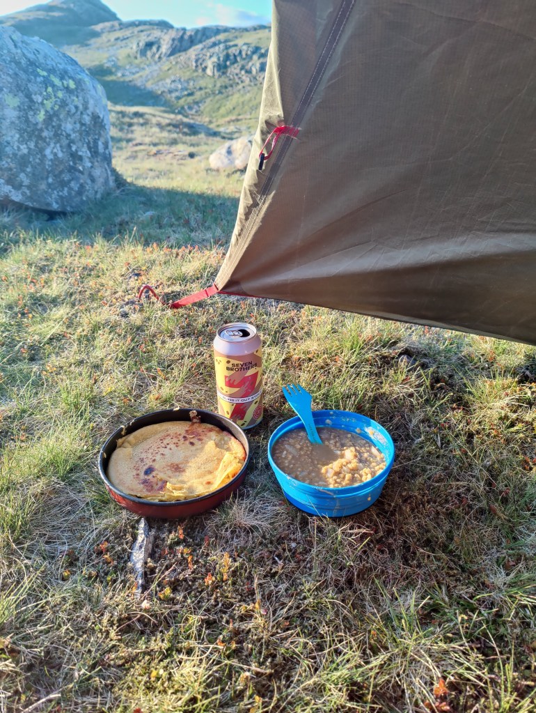
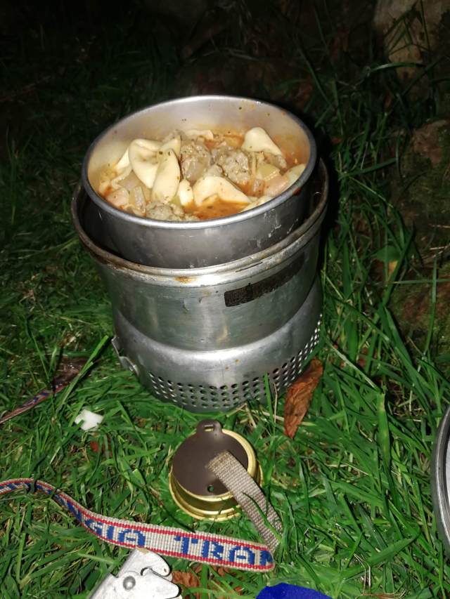
I was absolutely shattered, exhausted almost to the point of nausea. Tent up, everything inside, I was finally able to rest. My first priority was to go out again and fetch water, and then, drink water. I was concerned that I was dehydrated. Then, dry clothes, ibuprofen, and some Ralgex for my shoulder. After a while just sitting, I began to feel a bit better, and started to prepare my supper. This was red lentil dhal with garlic and onion and spinach, and some farinata – chick pea pancakes, washed down with red wine carried onto the hill in a plastic water bottle. It was a most excellent supper.
A most excellent supper
My new lantern performed well, though the limits of the battery were starting to show. It flickered several times and then switched itself to a dimmer setting. I had not bought the charging cable. No matter; the lantern is a game-changer for dark season camping, as it weighs barely 80g and is about half the size of a pack of cards. And so to bed – not long after 7pm.
30/10/24
I slept passably well. In fact I slept very well, on both nights. When sleeping on the ground (even using a Therma-Rest mat) I’m accustomed to reaching for the brufen as soon as I wake up. Yesterday it was not necessary. Today, whilst I did drop 400mg brufen as soon as I got up, it was not so much for aches and pains as prophylactic, to ward off shoulder discomfort later. I took it easy; there was no rush: I was out of my pit before dawn on a very mild morning. I had insufficient water in my tent and could not be bothered to get my trousers on and my boots on and laced up, which would have been necessary to get more water. This meant that I did not have any coffee or hot chocolate. Another advantage of eschewing coffee is that the subsequent need to make use of the sh1t shovel can hopefully be delayed until reaching civilised facilities. Unfortunately, this morning that was not possible.
For breakfast, porridge with melted chocolate and malt whisky, although I had eaten half of it before I realised I ought (at least on the hill) put sugar in it as well! This was followed by a mess of chorizo, spinach, tomato, pitta bread and melted cheese, fried in a little oil. Breakfast of champions! That said, I would not again use pitta bread and will resort to more usual western forms of bread next time. I struck camp in half light and was away hiking up the forest road before 0740. Up to within a kilometre of the Black Sail hut, there is a good road, easily passable in any car. For the last kilometre a 4WD vehicle would be absolutely necessary. This good road does belie the hostel’s reputation as the most remote youth hostel in England. Ennerdale is stupendous in its magnificent wild beauty, even in these heavily clouded conditions, and even though the whole valley is an industrial plantation. The clouds part occasionally to reveal the heights of Pillar and other peaks. Of all the great valleys of the Lakes I like Ennerdale the best; it reminds me of the music of Sibelius. I passed the Black Sail hut at 0800 hours.
A few navigational errors saw me on the path up Seary Knott onto Fleetwith – not what I wanted. I had to turn back, and I found myself wandering through a field of immense drumlins. Part of the problem is that that the path as marked on the OS map, and as it exists on the ground, is different. The path on the OS map is a straight line directly uphill up the tongue between Tongue Beck and the main Liza river. The path on the ground is a windy route up the crest of the “Tongue”. I laboured up this path into the mists, zigzagging through the grey clag, hat on sometimes, hat off when I overheated. In this mist l stuck to the path like it was my only friend. Everywhere, sheepsh*t. I never saw so many sheep, and so much sheepsh*t, as in the Lakes this Autumn. It made me reluctant to drink from the mountain streams without using Puritabs.
After a long plod uphill, I reached a T-junction; the path crossed Moses Trod, a named path weaving across the mountainside from Brandreth to Kirk Fell. Along Moses Trod, counting paces, until I reached the point where I must strike uphill, over red screes and deep in the enclosing mist, steeply uphill to Windy Gap. As I reached Windy Gap, I saw a man with a dog. This was exactly what I saw the last time I was here, in very different weather conditions five years ago. Today we were enclosed in the mist; five years ago I could see the Irish Sea. Windy Gap is a tight and narrow col between Green Gable and Great Gable. I have been here a half dozen times in my life, the first being as long ago as 1979. It was 0930 – slightly under two hours from the Ennerdale valley floor.
Some chocolate and trail mix and the remains of my water to refresh myself and onwards down Aaron Slack. At first, it is a rough but easily manageable scree, but further down it becomes a very good staircase. That said, the stone steps were somewhat slippery in the wet when going downhill. That might be a weakness of these boots. As I moved carefully downhill, four figures appeared behind me, moving very fast. No rucksacks. At first I thought they were runners or perhaps military personnel – but no, they were just young lads. I had a pleasant chat with one of them, who had the grace to dimple when I said (of my slower pace) “Oh to be nineteen”. The four of them were most polite and civilised members of the Praetorian Guard of youth, with all their lives ahead of them.
Down to Sty Head; find the tarn in the grey mist, yomp up to the top of the pass in thick clag. Then, briefly in company with four more youths, one female, I had some difficulty in this thick mist, with locating the Sprinkling Tarn path. Find out using GPS exactly where I am, then, some compass work, some counting paces, and the path was found easily enough. Onwards and upwards, now and for the rest of the hike, on strong Lakeland paths, motorways amongst mountain tracks. Halfway up I was pausing for breath when I was surprised and a little mortified to be overtaken. I was overtaken by a substantial (at least a dozen) party of what looked like U3A hikers to me, not one of them except their leader a day younger than I, and all (except for their guide) carrying tiny knapsacks. I was hauling probably 18kg of wet expedition bag, and had hiked 45 km since Monday lunch time. In fact, starting off again, I kept pace with them and started to overhaul them, but they turned off to the right into the mists.
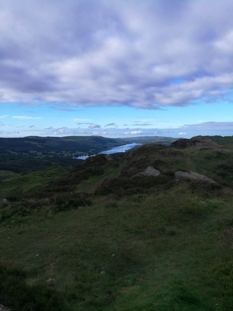
At Sprinkling Tarn, though it was barely 1100, I stopped for a very early lunch, sat in what little shelter I could find by the brown moor, the steel-grey rippled lake. The clouds lowered. I pushed on, passing through an area where clearly there had once been a tarn. The geography was all corrie, though the only trace of dried up lake was the colour of the grass and a marshy area. Up to a broad col where going wrong would have taken me up to Esk Hause, which was not at all necessary today. Esk Hause is that spot in the Lake District furthest from a metalled road. It’s about 2.5 miles to Rosthwaite in Borrowdale, to the Wasdale Head Inn in Wasdale, and about the same (using Rossett Gill) to the Dungeon Ghyll in Great Langdale – my final destination today. Coming down from the col I passed two young people, a man and a woman, working on some repairs to the path. And so by degrees down to Angle Tarn, my third and final grey lake in the clouds of the day. Styhead Tarn, Sprinkling Tarn, Angle Tarn. To think we camped here when I was but 16! What were we thinking of? In warm and dry conditions, fair enough. In wind, cloud and wet, not so much.
In all this hike there has been no actual rain at all, and it has been mild to a remarkable degree. The wind has not risen so much as to rattle my tent. I could have done with some wind to cool me down, dry my sweaty clothes and dry my tent. I wore gloves for perhaps 5% of the time I spent hiking. From Angle Tarn, along the contours or perhaps slightly uphill , to the right of Lining Crag, and thence down, below the mist line, to the “Pile of Stones” at the top of the Stake Pass.
The top of Stake Pass seen in the distance as the mist clears
In effect, job done. It was just around 2pm. Downward then, along a good staircase down into Mickleden, and then along the flat of Mickleden to the Old Dungeon Ghyll Hotel, whence I arrived, tired and footsore, a little after 3pm.
Mickleden, seen from some way down the Stake Pass
I hiked a little over 55km in three stages over a little less than twenty hours. From Keswick to Pudding Beck was 9.7 km over 3 hr 23 minutes. From Pudding Beck to my camp in Ennerdale was 26.4 km in 9 hrs 16 minutes, finishing after dark. From Ennerdale to the Dungeon Ghyll via Sprinkling Tarn was 19.4km in 7 hrs.
Here are a number of accounts of climbing the Sharp Edge of Blencathra, over thirty years. The first, in the mid-1980’s, and most recently in 2015.
This wonderful modern (2022) photograph of the Sharp Edge of Blencathra is courtesy of Dave Massey Photography https://davemassey.photography (permission to reproduce, applied for)
25/7/85
From Castlerigg into Keswick. Then we tramped out, eventually hitting the disused railway. It was a hot, hazy, blue sky kind of day. Under the big A66 bridge, and some of the old river bridges had a very Canadian feel to them. Splendid scenery. We left the old railway and crossed several fields to a road, which we followed down into a ravine. We stopped in the shade by the babbling brook, a lovely spot encouraging lassitude, but eventually we had to push on.
Up the hillside as the sun beat down on us. This is your Mousthwaite Combe. We laboured up a grassy path up onto the shoulder, which offered amazing views. FM radio reception was quite remarkable – we were listening to Q102 Dublin on our walkmans – in stereo. We continued onto the summit, not taking the route via Sharp Edge on this occasion. We dropped back down to the road arriving at the Salutation Inn in Threlkeld for an excellent bar meal. From there after a pleasant drink, we walked back to Castlerigg in the gloaming.
13/10/85
A large party of ten for a mass ascent of Blencathra! From the inn we moved along a road and struck left into a short valley, across the headwall of which, could be seen our path, forming a diagonal upwards. Mousthwaite Combe. At the top, we found ourselves on a broad whale-back, with a deep valley below. In it, the gloriously Tolkienesque River Glenderamackin. [Tolkienesque to me that is, not to the younger fellow who wrote this account in 1985; he knew nothing of Tolkien when he was 20.]
Along the left side of this valley, before climbing steeply up into the corrie of Scales Tarn. This is really impressive rock scenery, particularly Sharp Edge. One member of our party, somewhat afraid of heights and exposure, went up the screes to the summit. The rest of us went up Sharp Edge, with K. and R. at the front, and myself and T. J Walmsley shepherding one or two less experienced walkers in the rear.
It was my first time here on what became and what remains probably my favourite route. I found it passably sharp, suitably impressive and very exposed, but too short. It looks a lot worse than it is from a long way off. When you think of the great ridge walks in the British Isles, the Sharp Edge of Blencathra is by no means least among them, though is one of the shorter routes, the crux of it being only a hundred yards long. Even Crib Goch is only a few hundred yards of really sharp rock ridge mixed in with a mile or so of reasonably narrow ridge walking. For sustained narrow rock edge work you have to go to the Aonach Eagach above Glen Coe, which is miles long. But that’s not passable in winter conditions for walkers.
The route lies up over some gendarmes and up onto the summit where we had lunch. To the north there are many kilometres of wild moorland, but not particularly exciting hill country. At the top, it started to mist up. Blencathra has little to recommend it but Sharp Edge, and the descent was tedious. This being a Sunday, it had to be a short day – 4 hours on the hill. But satisfying for all that.
11/2/89
On a windy day, myself and J. Parkinson walked into Blencathra through low cloud. There was a fair amount of snow visible in the corrie of Scales Tarn. Sharp Edge itself was in cloud and the rock was exceptionally greasy to the fingers and to the boots. There was little snow on the ridge itself, but a fair bit on the face at the end.
We did not reach the summit: My friend noted that he was in his element roofing, sitting on the crown of a house in the urban environment, and had no problem with heights, but the conditions here put us both out of our element. The rock cold and greasy, we withdrew safely.
Always know when to turn back. A key lesson for the mountaineer, learned here at no cost. I’ve been fortunate over many years to learn some important lessons in mountaincraft at very, very modest cost.
9/1/91
Myself and R.C.E Ball, in heavy standing snow but clearing weather, climbed up into Mousthwaite Combe. It was windy; spindrift was troublesome to us the whole day. The path round to Scales Tarn was barely visible under the snow. In places, folds in the land caused very deep snowdrifts to form, hindering our progress considerably.
We got into the Scales Tarn corrie about 1.30pm. Scales Tarn itself was frozen. The main part of Sharp Edge was great sport, if spoiled somewhat by constant spindrift storms. There was hard frozen snow from previous falls, as well as fresh snow. The crest up to the summit was technically very difficult in winter conditions, as we neither of us were carrying ice axes or crampons. An axe would have been a great help. The snow was very hard, the rocks iced over to eliminate all handholds, and footholds were hard to make.
The summit plateau was lethal verglas. We got up and off quickly but with considerable difficulty, via Scales Fell, and good glissading (or bumslides in this case) down to Mousthwaite Combe. We were the first party on the hill after heavy snow.
The previous day, 8/1/91, we’d taken a short stroll from our camp at Braithwaite, up Stile End to Overside (1863′), before retreating before a blizzard in late afternoon. A warming up stroll terminated abruptly by a heavy snowstorm.
10/3/92
We were on the hill (that is, into Mousthwaite Combe) by 12.15pm. We arrived in the Scales Tarn corrie around an hour later. There was an attack of hail as we climbed up to Sharp Edge. The conditions were excellent. Up on the top of Blencathra we could see Styhead Tarn glinting in the distance. We detoured around for extra hill-walking – Blencathra is a short route. However, the weather worsened and a snow squall forced us to shelter. So we came down and were off the hill by 4p.m.
I think this is the time we went to camp at Castlerigg, but decided to go to a B&B in Keswick instead. I recall getting wet even opening the car door, at the campsite up at Castlerigg, and we thought, “No.”
26/6/15
We drove through to Scales and set off up Blencathra at about 2pm, in good weather.
As we got into the corrie of Scales Tarn, the weather broke big time, and our scramble up Sharp Edge was lethal. Conditions were very greasy and slippery underfoot. The mist was down, and for a time it rained quite heavily. My young colleague had never been here and struggled with confidence. We got up Sharp Edge only after long meditation and careful consideration. In any case, to withdraw from Sharp Edge in those conditions would have been more hazardous than going on. An ascent of the Sharp Edge of Blencathra is no mean achievement in any conditions.
So, on and up we went, and we were soon finished. We were further encouraged by three friendly men making their way slowly up the ridge behind us with much talk and laughter. After the summit we descended through pleasant afternoon sunshine to the car and drove directly to Honister Hause YHA. We checked in and had the cup of tea we as Englishmen had been desiring for some time. I saw that Youth Hostels are now licensed. Supper was at the Fish Hotel in Buttermere, taken outside, on a very clear and pleasant evening.
About eighteen months ago I went to the Lakes for a bit of wild camping. In the final paragraph of my trip report here, I wrote this: “had I known that public transport in the Lake District was so comprehensive and so well co-ordinated, I would never have brought the car at all. From where I live in East Surrey, the train would be about the same journey time, maybe slightly quicker, and a good deal less tiresome than trudging up and down the M40 and the M6. The train might cost a good deal more than the cost of the fuel – but as any fule kno, the cost of fuel isn’t the true or full cost of motoring.“
I journeyed to Windermere by train. Leaving my home in East Surrey just before 0700, I was in Windermere just after noon. It is the Pendolino tilting train that makes this worthwhile and possible, from Euston to Kendal in three hours. The cost was not excessive at £133 return in standard class. After a scotch egg and a bottle of pale ale sat in a sun-soaked corner in Windermere, I took bus 508 up Kirkstone Pass, for £5.10, with a very cheerful and friendly driver who said, “It’s a while since I’ve driven this route. Let’s hope I can remember it”. There were two other passengers.
At the Kirkstone Pass Inn I hopped off in bright sunshine. As I was rigging my bag for hiking, seven or eight motorcycle warriors of one tribe or another roared through on their throaty Harley-Davidsons. It was 2pm. Grinning and confident in physical fitness, I set off up the hill, and was on the first top, Red Screes (776m). From there, along to Scandale Pass and little Scandale Tarn. Here there was a squall and in five minutes I went from using a sun hat to wearing gloves. That’s the Lake District for you – never underestimate the mountains. Further on, to Dove Crag, Hart Crag and finally Fairfield (873m) whence I arrived at 5.10pm. I’d been this way before, some time in the 1990’s. Here you can see the difference between winter and summer conditions:
The first time I was on Fairfield was in shouting rough conditions in about 1979 or 1980, with a school party on a YHA trip. It would hardly be allowed now. From there, down to the somehow ever-gloomy Grizedale Tarn. It is a long way down. Another location with deep memory for me, from that same YHA trip, only the second or third time I’d ever visited the Lakes.
It was with some difficulty that I found a place to pitch my tent. The aspect was geographically similar to that tarn in the Cairngorms (Loch nan Stuirteag) where I’d experienced difficulties last November. A high tarn flowing east down into a wild valley, no obvious camp ground at the outfall and a rising wind. But, a place to camp I found, by the babbling brook, and soon enough it was supper time: fresh tortellini and a tin of 8% stout. I was drowsy; I hardly thought at all. I was in bed asleep well before 9pm. I found that lying in my sleeping bag in the tent, listening to the babbling of the brook, I could be in a place where I was not thinking about anything: awake, but barely even conscious.
I was wide awake by 6a.m and set off at 8a.m, tent dry, ready for adventure. I was on Dollywaggon Pike before 9.30a.m, and from there to Nethermost Pike (891m) and onto Helvellyn (969m) before 10a.m. The first and strongest of the day-trippers were already there, some Scotsmen with good camera equipment. Absolutely stupendous visibility!! Just look at these below. I spent some time talking to the Scotsmen, reflecting that the last time I was here was in winter conditions in 1997.
Ullswater
Striding Edge from an unusual angle
Swirral Edge, Red Tarn, and almost the entire length of Ullswater in the distance
And then, down, through the long morning. Although earlier on there had been few enough people on the mountain, I passed many dozens of folk toiling up the long and arduous ascent of Helvellyn from the Thirlmere side. Why would anyone climb Helvellyn from that side? A dreadful slog, it is. I suppose the ascent from the Patterdale side, involving as it must, either Swirral Edge or Striding Edge, is not for everyone. And not for me, is that steep downhill to Thirlmere: by the time I got to the valley floor, about 11a.m, I was tired and I had stubbed toes. It was very warm and sunny – again, absolutely delightful conditions for photography.
I was starting to think, where will I fill up on water? Odd to be in a reservoir valley, yet for there to be no instantly available drinking water. Water, water, everywhere, but not a drop to drink…there was a long and somewhat tiring slog through admittedly delightful woods up along the eastern shore of the reservoir, as far as the dam, where I stopped for lunch. Boots off, charge my devices, and sit in a sun-soaked corner. Lunch was bread and butter, cheese, tomatoes, and a little Chorizo sausage. An orange, some chocolate and some trail mix. I drank the remainder of my water. Now I really needed to fill up.
As I set off again, a trio of hikers passed me, two young women and a young man, all festooned with clanking cups and pans and camping equipment hung on their rucsacs. I confess I don’t like it for there to be any stuff attached to the outside of my rucsac. I prefer the clean lines of climbers’ rucsacs and generally don’t even do side-pockets if I can avoid it. One of the girls stopped to chat. It seems that they perhaps, did not realise when they arrived last night, that camping is strictly prohibited on the Thirlmere valley floor. I was just pleased to hear someone speak in a Lancashire accent, whatever this youngster was telling me.
At Armboth, I managed to fill up my water bottles, though I deemed it necessary to add purifying tablets. Onwards and upwards literally; the second ascent of the day, from Thirlmere up over the moor to Watendlath. I shouldn’t have cared to come through here in claggy conditions; the moor, as well as being boggy, was pathless and featureless; one should find oneself very soon resorting to the compass in poor visibility. Initially it was a very pleasant walk through steep meadows with unusual flowers, leading up onto a rather boggy moor. I found this hard going as it was now mid-afternoon and I was carrying 3kg of additional water. And so it was that for the first time in my life I found myself visiting the little hamlet of Watendlath, nestled in a hanging valley between Borrowdale and the Thirlmere valley. There was a tea rooms, and I stopped for a pot of some of the best tea I’ve had for ages, along with some rather nice tea bread. It was 4pm.
From Watendlath, one skirts the eponymous tarn and sets off up a good bridleway to Rosthwaite in Borrowdale. This was an ancient, traditional and much-trod road. It made me think of those many passes of Lakeland through which there is no tarmac road. Sticks Pass across these very moors. The Walna Scar Road between Coniston and Dunnerdale. The Black Sail Pass from Wasdale to Ennerdale. The Scarth Gap between Ennerdale and Buttermere, and the biggest and most important of them all perhaps, the central pass of the Lake District, Sty Head between Borrowdale and Wasdale. There will be others. I came down towards Rosthwaite late afternoon, again, in glorious sunshine, with the aforementioned Sty Head pass visible in the distance, as well as the bright specks of distant cars in the Honister Pass reflecting the sunshine. And all the time, the sound of lambs, and occasional cuckoos.
Sty Head is the notch in the middle of this picture, with the dark mountain behind it.
At Rosthwaite I stopped at about 5.20pm for a pint of ice-cold lager, primarily so I could sit in range of WiFi and update my wife on my location. Though the pint was very welcome, it was secondary to my purpose. Clearly EE don’t have a mast in Borrowdale.
Onwards: first, another tiresome road tramp along around 2km of tarmac, before turning left into the fields again on a path to my final destination today, Tarn at leaves, where I planned to camp. Though at best 2km from the road, it was strongly upstairs, really quite steep. The sun was at my back and though I was flagging towards the end of the long day, I knew I needed to get there. “You’ve got this” I told myself, and I had. I was a little concerned though, that there were no paths onwards from Tarn at leaves. This concern had some justification; the map, as far as it goes in terms of detail (which is not far even on the OS 1:25000 sheet) showed none. But this isn’t the Cairngorms in November. I finally got to the tarn and found it very boggy, going in up to my knees and getting my boots wet right in the last two minutes of an immense twelve-hour day on the hill. But it all dried out quick enough.
I was sat down to my supper quite late – about 8.30pm. For supper I had spicy red lentils, and a chick pea flour pancake – a “faranata” the recipe for which I learned from my son Nat. I can’t be doing with not eating and drinking well when camping wild. To wash my dinner down I had some remarkable and very tasty 8% proof “Sling it out Stout” (though to be fair after that walk of nearly 25km, even Carling Black Label would have tasted like nectar. Well, that’s pushing it a bit, maybe…
The place was well deserted. Though I was happy enough, it reminded me of a sad part of Tolkien. Hurin, released by the devil Morgoth after 28 years in captivity, wanders over the land trying to find the hidden city of Gondolin, whose king Turgon, was once his friend. He knew roughly where it lay, but not exactly. And on some deserted moor, where the wind whistled endlessly through the grass while no-one was listening, he cried out in grief and rage, “where are you, O Turgon, in your hidden halls?” But someone was listening…Morgoth’s hidden servants reported those words back, and the betrayal of Gondolin began.
This tarn is one of those past its former glory, slowly drying out. Slow by no human perspective – it’s climate change alright, but not as we know it. It’s nothing to do with man-made climate change. Tarns like these have been drying out in the Lake District since the ice receded these 10,000 years. There are dozens of them. The word “moss” is often a giveaway, for example, at the Great Moss under Scafell Pike: even a cursory glance at the map tells you there was once a lake there. For all the boggy areas in which went up to my knees when I arrived in the evening, it was a dry camp and a dry strike. After a breakfast of mushrooms, spinach and fresh coffee, I was away again by 8a.m the next morning. What I could not do, is find fresh water to drink. I set off onto the hill with less than a litre of water left, but with a few little oranges and tomatoes.
It was not clear to me where to go from the tarn; I did not want to end up scrambling up and down bands of cliffs: unwise at any time if you’re on your own, a recipe for a coffin or worse if you’re carrying a 20kg rucsac. Once you stumble, down you will go. Don’t stumble!! I pressed on, keeping the dark and seemingly endless (and appropriately named) valley of Langstrath on my left. I remember being in it once on a rainy day, thinking it went on for ever. And I found a fence. Where a man can build a fence, I can safely walk. I followed that fence for quite some way before leaving it, saying farewell as to an old friend, and striking uphill towards Glaramara (783m). I was an hour and ten minutes walking this morning before I encountered a path. That is unusual for the Lakes.
Glaramara unfortunately has a short scramble which I did not recall from last time I was here (which to be fair was 36 years ago when I was a callow youth.) But keeping one’s weight forward works for climbing with a big bag; slightly less unnerving than climbing downward face-out, when the weight and centre of gravity must be kept back to avoid to avoid toppling over and down. I did not expect to see anyone here this early (9.30a.m) on a Sunday morning – way too early for day trippers to get to this location. The summit was deserted and cold. For a short while it was cold enough for me to wear my woolly hat. On the next summit I did in fact meet and have a pleasant chat with a young backpacker, who had camped on the shoulder of Scafell Pike at over 950m above sea level. We spoke of obtaining water; he noted that water flowing in streams off the central massif could be polluted and a problem: he was planning a two-night Mountain Leader Training exam expedition soon, and obtaining water in summer conditions, was a challenge. I was drinking water I’d carried all the way from Thirlmere.
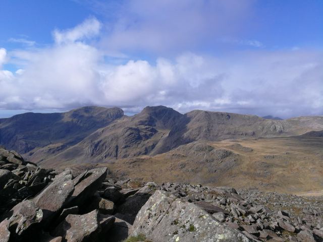
Again onwards to Esk Pike and Esk Hause, the central col and cross-roads of all the Lake District. Also about as far as you can get from a road-head anywhere in the Lakes, although paradoxically enough, probably not the remotest location. Here there were day trippers, mostly up from Seathwaite, Borrowdale. Round here one reflects on the centrality, not of Esk Hause, but of Great Gable. It’s not the highest mountain of course, but it is the central boss, the ice-worn stub of whatever original mountain stood here millions of years ago. Near here I saw some classic “roche moutonnee” (literally “mutton rock”, rock like sheep) whereon there were clear scratches from the ice, quite at odds with the rock’s natural bedding plane, the scratches pointing towards Great Gable in one direction, and down-valley in the other. I do like the landforms left by the glaciers. The hanging valleys, the corries and cols. Truncated spurs. Misfit streams. Terminal moraines. Eskers and drumlins.
Drumlins in Langstrath
Round to Bow Fell, where I started to feel hungry and took lunch. On Bow Fell I encountered an older fellow with his young son, and he was teaching him the names of the summits on the skyline, testing him so he would learn them. I know them, and no-one taught me their names. But I am an older man and I’ve been coming to the Lake District for over forty years. My first trip was in 1977, to the Newlands valley with the Scouts, and we climbed Dale Head in claggy conditions. I remember it fondly. But it is something that would not be permitted today, for two Scouters with no Mountain Leader certification or formal training to take 16 young Scouts on a hike like that.
From Bow Fell, descending carefully, I went down to Three Tarns, where I saw that fellow again with his young son. I was most careful going downhill, though it seemed straightforward enough. I became aware that having climbed Bow Fell half a dozen times at least, I’d never come down this route, only up it. From Bow Fell, at a little after 2pm, I went down The Band, increasingly footsore, until I found myself very slow and very tired at Stool End Farm, about 3.30pm. A child was playing in the farmyard as I passed through, and my hike was over.
The geeky stuff
On day 1 I walked 9.57km; on day 2, 24.46km, and on day 3, I walked 14.28km, to a total of 48km in just a bit less than 21 hours total. On the second day, the 24km was taken over 9 hours and 49 minutes and involved four separate ascents, three from the road.
I used an Osprey Aether Pro 70 which weighed 14kg laden with no food or water. Add to that around 3.7kg of water, 900g of beer and all my food, means that at the start I was packing somewhere between 20kg and 21kg. This is a lot less than I was carrying with my previous rucsac which was about 10 litres larger but a good deal heavier. I’ve written about this before.
I slept in an MSR Elixir 2 tent, and used an Alpkit Skye High 700 4-season down bag, a silk liner, and a Thermarest self-inflating mattress. I used a small Trangia 27 and a small (750ml) metal bottle of bioethanol. I carried gloves and mittens (and used the gloves), a woolly hat and a sun hat (and used both), Goretex waterproof trousers (didn’t use) and Goretex gaiters (did use). I carried about 800g of Lithium battery power packs as well as a cellphone and a smart watch. Spare clothes, waterproof coat, fleece jacket, first aid kit, small pair of field glasses, and a few other bits and bobs, made up the kit list.
I found the Aether Pro too small for my purposes and the tent had to be strapped to the outside. But the extremely light weight of the Aether Pro carries all before it – I love that aspect of it. After a day or so I became adapt at re-packing and found things fitted better, and eventually the tent fitted inside. I have not yet had the Aether Pro out in heavy weather, so I don’t know how waterproof it is without a rain cover.
Well I’ve done it! I’ve read fifty-two books this year! I think I can be proud of that. Some of them I have even reviewed properly. We’ll not go through them all in excruciating detail here, but we will discuss broadly, my year’s reading. I never set out to read a book a week, but I did set out for sure, to read many dozens of books in the year.
Of the 52, 15 of them were in my Kindle – I can do both paper books and e-reading. Eight of the books were re-reads. A few of those only, will I highlight. Nicholas Monsarrat’s “The Cruel Sea” which I re-read after seeing the film one Sunday afternoon. C.S Lewis’ “The Great Divorce” remains one of my favourite reads, being an account of a man who dreamt of going on a day trip to Heaven – from a certain another place. Another re-read was R.A Heinlein’s “The moon is a harsh mistress”, at one level, a story about a rebellion in a prison colony in 2075: at another, the greatest manifesto for libertarian political views, you will ever read. Eighteen of the 52 books were fiction – an oddly low number, although it just means that my interests have been well satisfied by non-fiction.
I started the year reading Dr J.H. B Bell’s “A progress in mountaineering”. Bell, as a 16-year old in 1910, cycled 47 miles from Newtonmore to the foot of Ben Nevis, and climbed Nevis alone. And then he cycled back 47 miles again: the account does not make it clear if he cycled 90+ miles in hobnail boots, or if he climbed Nevis in plimsolls. What seems clear, is that when compared with our elders, we have become a nation of wuss.
I enjoyed Jonathan Nicholls’ “Kittyhawk down”, a well-researched story about RAF pilots in the Western desert during WWII. In February I also read Murray Rothbard’s short pamphlet “The Anatomy of the State” (Murray Rothbard also wrote “The fatal conceit” about the errors of socialism), and a book called “The road to Mecca” by Muhammed Asad, a Jewish convert to Islam, who later became a senior diplomat for the government of Pakistan. In March I read Robert Winder’s “The hidden springs of Englishness”, and started Neil Sheehan’s “A bright shining lie” reviewed here – if you read one book about Vietnam, make it this one.
My sister sent me an old copy of Rich Roll’s “Finding Ultra” about an overweight man who turned his life around and became one of the fittest ultra-marathon runners in the world. As much for the appendices on plant-based diet, did I find that book interesting. William Wordsworth’s original travel guide to the Lake District proved oddly relevant centuries after it was written. Having tried and failed to source a copy of Varlam Shalamov’s rare Kolyma Tales, instead I read Hugo Jacek-Bader’s excellent “Kolyma diaries” and “White fever”, about travels in Eastern Russia – startling stuff about a very different world.
I read some science-fiction: Amongst others, Paul McAuley (“The war of maps”), Iain M Banks (“The Algrebraist” – again), an old Keith Laumer novel and two works of the modern writer Adrian Tchaikovsky. Also Heinlein – “Glory Road” (is that even sci-fi??) and “Harsh mistress” as already mentioned. Becky Chambers’ “The Long Way to a Small, Angry Planet” I review here.
I read three books about India: Shashi Tharoor’s (perhaps understandably) bitter and twisted “Inglorious Empire”, William Dalrymple’s account of the East India Company entitled “The Anarchy”, and finally Katie Hickman’s “She-merchants, buccaneers and gentlewomen: British women in India”. All very informative and enabling one to gain a more accurate perspective of world history. The lesson from Shashi Tharoor’s “Inglorious Empire” is that bitterness and negativity, however arguably justifiable, is deeply unattractive.
I have read much about America: I am a fan of America. I believe in what America stands for, though it seem to be in trouble in these times and full of vice and failings. Robert Kaplan’s “Earning the Rockies: How Geography Shapes America’s Role in the World”, reviewed here, proved very interesting at the start but perhaps a little disingenous towards the end. A great interest of mine is American history, particularly the westward expansion. I read Bernard Devoto’s; “1846: the year of decision” and John Anthony Caruso’s “The Appalachian Frontier” , was well as several of Dee Brown’s books – one on the Fetterman Massacre, the other on women in the wild west. Dee Brown’s greatest and most famous book, all should read: that is “Bury my heart at Wounded Knee”, an account of the destruction of the native American tribes.
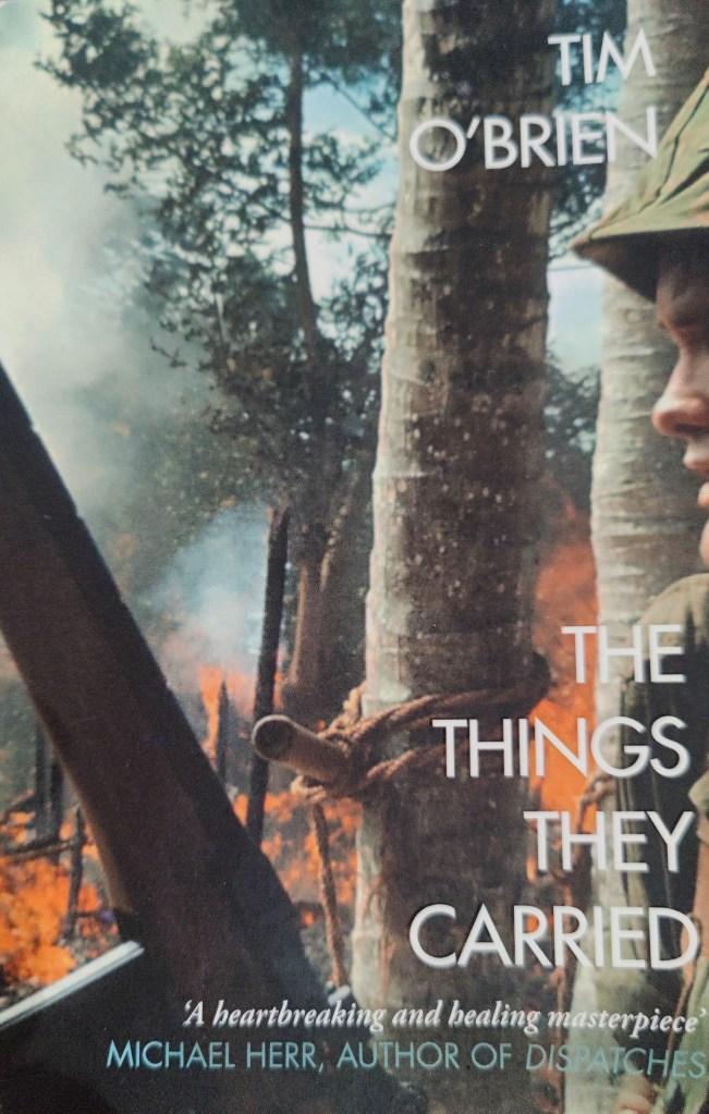
Later in the year I read Tim O’Brien’s “The things they carried” – the Vietnam war as seen through the lens of what soldiers carried with them. One soldier carried a pair of his girlfriend’s tights as a neckscarf, and wore them even after she dumped him. Also, I read Stephen Hough’s “The Great War at sea” – most informative – and Alice Roberts’ “Tamed – ten species that changed our world”. Self-explanatory title there, and rather a lot of detailed biology which I had to skip.
I read Ed Husain’s troubling account of journeys in certain cities in the UK – “Among the mosques”. In order to get published, Ed Husain has to be upbeat and positive about what is happening with Islam in the United Kingdom today, but I find that he can’t possibly be as naive as he comes across in his writing. A deeply worrying travelogue.
Tim Butcher wrote “Blood River”. The age of great explorers, opines one of the reviewers, is not dead. Butcher attempts with only partial success to navigate overland by motorcycle and boat, from the eastern Congo through to the Atlantic coast. The Congo is a messed-up place, and it is deeply messed up for a number of very complicated reasons. It will get worse – much worse. Certain important minerals essential for modern Lithium-ion batteries, required for what some people call “the energy transition”, are most easily sourced in the Congo. In the coming decades the extraction of those minerals, to salve the western conscience and enable electric cars, will do as much damage to Africans in the Congo as King Leopold ever did in his extraction of rubber in the early 20th century.
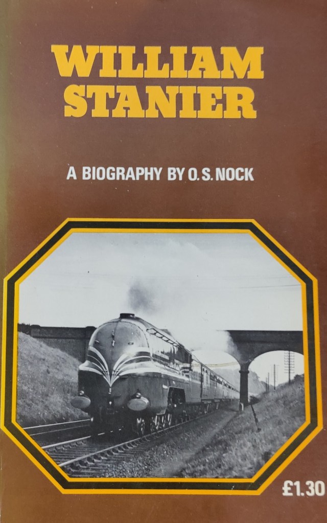
I read a useful and informative biography of Sir William Stanier by the ever-readable and prolific railway author O.S Nock. This one I found in an excellent second-hand bookshop in Bridport. I read Ryzard Kapuchinsky’s “Imperium” about Soviet Russia – including an unforgettable two-page interlude on how to make peach brandy. What drives my reading, is this – not what is in plain view, but what is not. Sometimes something tangential – a fact or anecdote of paramount importance or of deep interest, is almost literally found “in between the lines”.
I ended the year with David Halberstam’s “The Coldest Winter”. This is a brilliant account of the Korean War. Another great Pulitzer prize winning author covering vast sweeps of American culture and history. Though some of the descriptions of battles are a little too detailed for me, what made the book is the wide arc of history, the bigger picture. In a book about Korea, I learned much about the “New Deal” and the life and times of Franklin Roosevelt. I learned about changes to domestic politics in the USA that are still very much of importance today. I learned about McCarthyism, and also about Douglas MacArthur – a horribly fascinating, perhaps deservedly reviled, but nonetheless important 20th century figure. What’s it like to have no self-doubt at all? Lack of self-doubt is not one of my qualities.
Earlier in the year, I chanced across Francis Rossi & Rick Parfitt’s “Just for the record”, being an autobiography of Status Quo. This rock autobiography was a disappointment for me; it was potentially great story written in the most perfunctory manner. You would think that lyricists could write! No, obviously not. One thing I recall though is Rick Parfitt writing of himself as a teenager (when his guitar teacher patronised him) “No-one calls me laddie“. See my point above about lack of self-doubt.
Over Christmas I was given “Rainbow in the dark”, the autobiography of Ronnie James Dio. We learn that as a boy he swore to himself that one day he would headline at Madison Square Garden, in his own name – and he did! A readable enough tale of ambition fulfilled, of the virtues of hard work and persistence, and of some of the other less agreeable habits of rock ‘n roll stars. Reading it, I’d like also to read a biography of the guitarist Ritchie Blackmore, if and when such a book becomes available.
This is for balance, for unfortunately, Dio’s account of those years is somewhat self-serving. It is a shame, for I regard him as a great lyricist, and the distinctive sound of his voice, be it in the heavy metal music of Rainbow, or Black Sabbath, formed a background to my youth.
The full list here:
Chris Anderson The official TED guide to public speaking Paul McAuley The war of maps J. H B Bell A Progress in mountaineering Iain M Banks The Algebraist Jonathan Nicholls Kittyhawk Down Murray Rothbard Anatomy of the state Muhammed Asad The road to Mecca Robert Winder The Last Wolf: the Hidden Springs of Englishness Adrian Tchaikovsky Cage of souls Nicholas Monsarrat The Cruel Sea C.S Lewis The Great Divorce Neil Sheehan A bright shining lie Jacek Hugo-Bader Kolyma Diaries Rich Roll Finding Ultra William Wordsworth The Lakes Keith Laumer Doorstep Jacek Hugo-Bader White Fever Shashi Tharoor Inglorious Empire Robert D. Kaplan Earning the Rockies: How Geography Shapes America’s Role in the World Ryzard Kapuchinsky Imperium Dee Brown The Fetterman Massacre Bernard Werber Empire of the ants William Smethurst Writing for television William Dalrymple The Anarchy Sven Hassel Court Martial Becky Chambers The Long Way to a Small, Angry Planet Bernard DeVoto 1846:The year of decision Len Deighton Blitzkrieg Dee Brown The Gentle Tamers: Women of the Old Wild West John Anthony Caruso The Appalachian Frontier Larry McMurtry Lonesome dove Larry McMurtry Dead man’s walk Larry McMurtry Comanche Moon Francis Rossi & Rick Parfitt Just for the record – autobiography of Status Quo Michael Bonavia The birth of British Rail R.A Heinlein Glory Road R.A Heinlein The moon is a harsh mistress O.S Nock William Stanier Katie Hickman She-merchants, buccaneers and gentlewomen: British women in India Stephen Longstreet War cries on horseback George Orwell Animal Farm Ed Husain Among the mosques Richard Hough The Great War at sea Tim O’ Brien The things they carried Tim Butcher Blood River C.S Lewis That Hideous Strength O.S Nock The Settle and Carlisle railway Adrian Tchaikovsky Children of time Alice Roberts Tamed – ten species that changed our world Jeff Long Deeper David Halberstam The coldest winter: America and the Korean war Ronnie James Dio Rainbow in the dark
By Pendolino to Oxenholme, tilting through the heartland like an aircraft. In Lancashire the weather deteriorated, to pouring rain as the train called at Preston. At Oxenholme, to the Station Inn for a pint and then to camp in their garden. We were the only campers on a wet and windy Thursday evening. Next day, after a breakfast of champions prepared on a Trangia stove in a pub car park, to Sadgill at the head of Longsleddale.
We were away onto the hill before 0800. It was absolutely pouring. I’d not walked a hundred yards before regretting not fetching waterproof trousers. I stopped to put my gaiters on, which helped somewhat. Earlier in the week I had hurt my heel slightly mowing the lawn while wearing big boots with inadequate socks. I was now on the hill with both heels dressed in prophylactic, pre-emptive dressings, a kind of talisman, perhaps, to ward off blisters.
We plugged away up the valley to Gatescarth Pass. I read after our walk that when a railway through these lands was first proposed, back in the 1840s, one possibility considered was a route through Kendal and along Longsleddale, with a 2-mile tunnel under the Gatescarth Pass and into Mardale – the valley now filled with Haweswater. In the end of course, the route chosen for what is now the West Coast Main Line from London to Glasgow, took the much longer and steeper route over Shap and through the Lune valley. What might have been, eh?
Left up onto Harter Fell (778m) and squelch down to Nan Bield Pass, where there was a shelter, one side of which was exposed to the rough northerly wind. We hid behind it. There was a great view of Blea Water, and Haweswater directly “above” or behind it. Then, on up Mardale Ill Bell (760m) and onto the summit of High Street (828m) where it was possible – just, for they are in a north-south direction – to hide for a snack behind possibly the highest dry stone walls in the UK. They weren’t dry stone walls at that moment, I can assure you.
Then the long walk downhill to Patterdale, past the very picturesque and shapely Angle Tarn (I call this one the “other Angle Tarn” to distinguish it from the arguably better known Angle Tarn high up in the northern corrie of Esk Pike.) This gentler and larger Angle Tarn has a little island in the middle with trees on it! Onwards, down to the Patterdale valley floor as the rain eased somewhat. At one point we passed a frenzy of foxgloves, almost as if someone had gone out of their way to seed the hillside with that lovely flower.
At Patterdale we found welcome at neither the Ship Inn nor the Patterdale Inn. Desirous therefore, of leaving the hospitality of Patterdale behind us, we walked with some effort down the valley towards Glenridding. We found St Patrick’s Boat Landing, a little cafe up a flight of stairs, serving tea and cakes. Here we remained, wet and dripping but welcomed by mine host, for a couple of hours.
Refreshed, we set off again, walking up the eastern and more wild side of Patterdale, through delightful woods – a generation or two ago, one might have camped wild here in these remote woods both with impunity and with great pleasure. Perhaps not today – not really the done thing. We crossed to the right-hand side, walking alongside Brotherswater, through still more lovely woodland. At the campsite at Brotherswater, we found no room for us. To be fair, it was a Friday afternoon in late June, whatever the weather. Jaded, we took a short snack and set off yet again.
We slogged through improving weather, our waterproof gear coming off by degrees, until we reached Hayeswater. Here we made the most excellent camp, along with at least three other parties. Our supper was tortellini with pesto, washed down with some very strong beer, followed by chocolate and fruit. A 32 km hike in two halves.
Hayeswater
The next day, we had a breakfast of porridge and coffee, and then struck camp in light clag. We reversed yesterday’s route, more or less, back over High Street. No rain this time, but it was windy in places. In improving weather we descended into Longsleddale, for a total round of 45km in less than two days.
Thence by car to Bowness, thinking we might rent a canoe and relax with some boating on Windermere. But Bowness was full of tourists and there was nowhere to park. It made Ambleside on a busy Saturday afternoon look like a deserted hamlet. Dreadful place, possibly only the second time I’ve been there in my life; I shan’t willingly go back. We left, and took the chain ferry across the lake, and sat with a pint in Hawkshead.
Later, we met up with some friends, and in the golden evening, climbed up onto the summit of Holme Fell near Coniston, and camped right on the summit. Very fragrant and heathery. Sat on the summit we ate well – this time we had a spicy dal, and some Farinata – spicy chick pea pancakes. Though the evening grew cold, there was tremendous visibility and glorious views as the sun went down.
Coniston Water from Holme Fell – evening
Coniston Water from Holme Fell – morning
the central fells seen from Holme Fell, late evening
When I look back over more than forty years of hillwalking and mountaineering, starting in 1977 and continuing to the present day, there are a small handful of summits I find I have visited time and time again. Tryfan and Snowdon are two of them; Blencathra is a third. I was very surprised to find, when I started preserving my written mountaineering logbooks, that the Old Man of Coniston (803m) was actually quite high on my list.
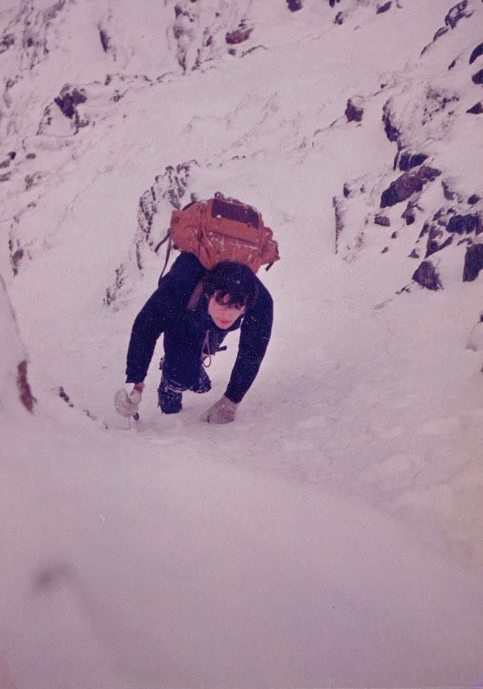
We visit the mountain here in February 1986, in what were superb, icy-cold snowy winter conditions: quite remarkable for the English Lake District even forty years ago. I rather suspect that we shall not in our lifetime see snow like that in the Lakes. But one may hope.
Five of us left the hut in Coniston and walked up the path, towards Low Water. A tedious slog saw us into the Low Water corrie in deep snow, where we practiced ice techniques for a while on a large, gently sloping icefall. We went on up a gully to the right of Low Water Crag. Apart from a steep grassy step, it was easy but very satisfying snow climbing. It brought us out in due course onto the unconscionably cold and icy summit of Brim Fell.
Nick Hough on Brim Fell February 1986
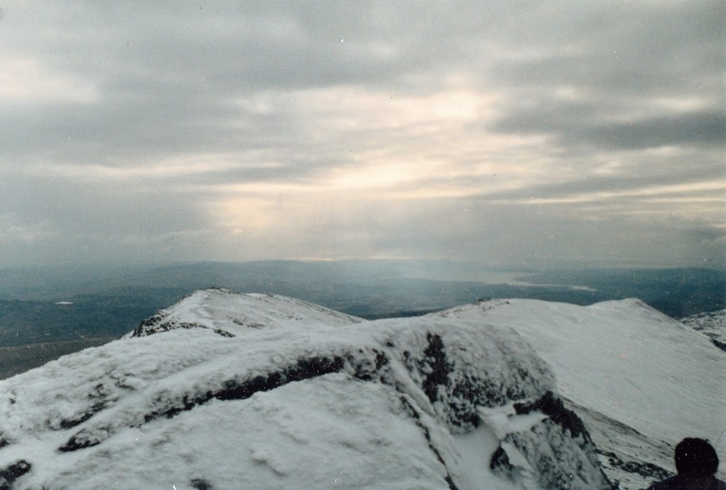
In mist we continued south along the ridge, which looked quite alarmingly sharp in winter conditions. Snow can sometimes have the effect of making the merely British hill look alpine, and give the appearance of difficulty to what is merely straightforward. I recall being told that one of the first French mountaineers to see the Snowdon Horseshoe in winter, in the late 19th century, wildly over-estimated the height, length and complexity of the route under winter conditions. The party got to the start of Crib Goch, and saw Snowdon in the distance, covered in snow, looking very Alpine. The french mountaineer declared that the summit of Snowdon was too far away to reach from where they stood, in daylight.
Coniston Old Man was iced over, but not completely covered; the Lakeland summits are not high enough to permit a serious build-up of snow. We left north, as the mist cleared to reveal Goat Hause and Dow Crag. We stopped for lunch at Goat Hause and continued across rather rough mixed ground, which was very hard on the crampons. This would be scree in summer and there would be a perfectly obvious path to follow. We were aiming for a snow gully at the northern end of Dow Crag. The first section was just drifted snow, but soon it became some rather trickier frozen-over grass and rock steps. Nearer the top we moved over a rocky rib into the next most southern gully, which was well in condition, packed with hard snow, especially near the top. It twisted away below us down to Goat Water. [It is entirely possible that the photograph of me that opens this article, was actually taken here. At 40 years remove I cannot be sure.]
Not sure where we are here: except it must be broadly west into the sun at that time of year and time of day. Possibly taken from Swirl How. The small lake middle left may be Devoke Water. February 1986.
This was fulfilling and satisfying work, a great end to the route as we scrambled out onto the summit of Dow, to clearing weather and the sight of the Scafell massif absolutely plastered in snow. The weather was photograph-clear. From Dow, we considered our options, and moved onto Grey Friar. When we got there, it was cold, and windy, and we were becoming rather tired. We thundered around the hause and up the gentle slope to Swirl How.
This is Seathwaite Tarn – a reservoir
From Swirl How there is a very steep ridged descent called the “Prison Band”. This was excellent sport downhill to Swirl Hause, and from there, down to Levers Water through a good foot of soft powdery snow. That was hard going. In the sky, pastel hues of pink and yellow, a beautiful evening in the making. An absolutely grand day. Down past the iced-over quarry roads through the Coppermines Valley, arriving at the hut around 5pm.
Levers Water, late afternoon, February 1986
The ongoing project of preserving paper notes of mountaineering and hillwalking going back as far as 1983, can be browsed here: https://plateroom28.blog/great-outdoors/
I set off from Surrey around 3pm, starting a 300 mile drive in to the Lake District. Whilst without incident as a drive,there was very heavy rain in the Chilterns and then again around Stoke-on-Trent. The M6 Tollway I think highly of – belting along there cost me £6.90 and probably shortened my total journey time by six minutes. What price money? There are people – quite a lot of people judging by the emptiness of the toll road – who refuse to use it as a matter of principle. I confess I cannot get my head round that attitude. Arguing that you can’t afford it, for a one-off journey, cuts no ice. Commuting might be different, of course. Maybe they object to the principle of roads being private property rather than public infrastructure.
I got to my B&B in Windermere in heavy rain, a little after 8.30p.m. Mine host was a rather eccentric and somewhat peremptory older man. Eccentric, in that he’d already admitted (as a businessman and B&B owner) to not possessing a mobile phone. To not own a mobile phone in Britain today, is in my view little more than a fashion statement. Not owning one as a B&B owner indicates an indifference to customers that I don’t find encouraging. Peremptory, in his attitude. Breakfast was exactly 8a.m and appear here in the hall and I’ll show you into the dining room. (This beats by some margin the narrow window “breakfast is 8.30 til 9, any time” offered by a cheery Australian landlady in Weymouth, which became a standing joke in our house for years afterwards.) Always remember – Fawlty Towers was not a sit-com: it was hard-hitting documentary.
My room was a typical B&B room, woodchip on the walls, a sink, no en-suite, comfy bed, tea-making facilities. I went out for a rather dank pint in a local pub, and went to bed, to sleep well enough.
Part II: from Great Langdale to Styhead
Next morning I went down at exactly 8a.m and mine host was waiting for me. He showed me into an empty dining room set for over a dozen people. He served me as good a Full English as ever I’ve had, with a pot of the strongest and tastiest coffee I’ve drunk in years. An excellent start to the day. Before 8.30a.m I had left – through the misty moisty morning to the head of Great Langdale, where I parked the car in some flat land near the road, a mile or so beyond the Old Dungeon Ghyll Hotel. Getting my gear right took some time, and it was probably near enough 10a.m before I set off.
My rucsac had weighed 16kg at home before so much as a bite to eat went in it. Now, it must have been well over 20kg. I hadn’t walked thirty yards before I wondered if I needed to take a longer warm-up. I considered walking the length of Mickleden, nice and flat, but that meant the horror of climbing Rossett Gill at the end. I decided to stick with going up The Band, so off I went towards Stool End Farm. And as I climbed, I came across the true deliverable of physical fitness. This last six months I’ve been running 20km a week. I walked up The Band in an hour and forty minutes, carrying a 20kg rucsac. I don’t say I didn’t break sweat, nor that it didn’t take it out of me, but my pulse stayed under 120 all the way. Happy with that!! At the top, a rest before continuing up Bow Fell, which despite it’s daunting aspect I found a straightforward ascent. At the top it was almost noon and there was a squall coming, so I stopped for lunch.
Scafell and Scafell Pike
From Bowfell I continued round the Scafell horseshoe. Ore Gap, Esk Pike, Esk Hause, but missing Great End. The weather was glorious, so I continued right on up to the summit of Scafell Pike itself, where I arrived at 4p.m.
Here you can see so much: an unnamed tarn on Middleboot Knotts, Great Gable, Styhead Tarn, and in the far distance, Derwentwater with Skiddaw clearly visible behind
It was cold. On a few occasions I had cause for concern that I should have brought mittens – as well as gloves. From Scafell Pike back down to the col and down the Corridor Route, starting to feel tired. But what wonderful light: Here’s the view down into Wasdale:
At one point, in the pleasant later afternoon sunshine, the path went down some very steep and rocky ground. You can do without that, when carrying a 20kg expedition bag. In Frank Herbert’s novel “The Dragon in the sea“, an old and wise submariner says to a more junior officer, “As a submariner, you only make the same mistake once“. For me as a man in my fifties carrying a huge rucsac, descending a rocky scree or boulder field, that was true. Here, I would only slip or put my foot wrong once. There would be no second chance. Taking the greatest care one does get down, though the thigh muscles ache. One has to be in the position of being able to lower, in a controlled way, your entire body weight, just on one leg. You have to keep your centre of gravity behind you – if it gets in front of you, you’ll topple over in an instant and game over man, game over…
Very tired, I reached Sty Head, and opted to camp there, on flat ground by a babbling brook.
Styhead
For supper I had fresh tortelini and some sausage, with onion, garlic and pesto. I use a very old and battered Trangia stove, the smaller “27” model. It has served me well for nearly 40 years. With this stove I feel rather like the proverbial man who has his father’s axe – I may have replaced some of the parts. On the hill I was munching through a small tiger loaf bought in Windermere, with Red Leicester cheese, butter, cherry tomatoes, and a satsuma. I was also using a trail mix of sultanas, raisins, seeds, salted peanuts and chocolate chips. This was inspired stuff – a mix of fast and slow energy. I learned this trick from a teacher when I was in school. And because I can afford the weight, a counsel of perfection for my evening meals was a bottle of Malbec, though wine and bottle weigh over a kilo. It’s an absolute fundamental to me that wild camping doesn’t mean rough or hard living. Camping doesn’t imply “roughing it”. Life offers enough difficulty as it is without adding further artificial complexity.
It was very cold overnight – an unpleasant cold breeze blew in through my air vents, til I shut them, at the expense of increased condensation. During the night the moon came out, which caused me some odd dreams and I did wake up briefly.
Part III: from Styhead to Buttermere – a round of Black Sail
My breakfast was porridge with a dash of Scotch, black coffee with a good deal of sugar, and a sausage. Breakfast of champions. Despite the cold and clear sunny morn, I had what was effectively a wet strike because of condensation. I shouldered my pack and set off towards the path. I passed a fellow out running with his dog, going in the Wasdale direction. It was about 9-ish. I reached the bottom of Aaron Slack and started up. The last time I was here, was twenty-odd years ago, coming off Great Gable with a friend of mine in absolutely dreadful weather: it was the time we met Todd, a lone American youth. Taaaarrrd, as he pronounced his own name, was rather over-equipped, we thought, at the time – probably August. I didn’t feel over-equipped now in October.
I was carrying an MSR Elixir 2 hike tent, an Alpkit three season down sleeping bag, a Thermarest mat, the smaller (size 27) Trangia and about a pint of fuel. A full set of spare clothes, a first aid kit, maps and compass, a hip flask, two litres of water, and food for two more days on the hill. Don’t forget the (hic) half a bottle of Malbec. And of course a pen-knife. And a small pair of field glasses. Waterproof trousers and jacket, fleece, scarf, gloves, wooly hat. And I carried that lot up to Windy Gap between Great Gable and Green Gable. And there, I met a chap with a dog. “Don’t I know you from somewhere?” I almost said. Sure enough, it was the same guy. In the time it had taken me to grind up Aaron Slack, he’d RUN up Great Gable and down the other side. And I thought I was fit. He had a friendly and well-mannered grey dog, which whilst I was sat down, came over to see me.
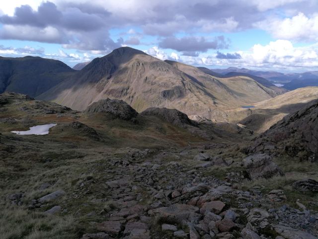
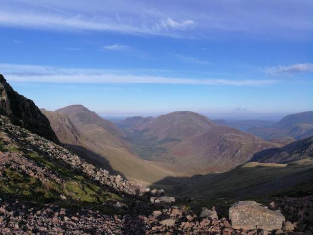
Just look at the view: Pillar is on the left there. Ennerdale centre, and Red Pike just right of centre. Crummock Water is visible to the right, and the coastal plain beyond all.
From Windy Gap onto Kirk Fell: my first navigational tactical error of the day. Staying high is always good advice when hillwalking, of course, particularly in such beautiful weather. I could descend all the way down to the Black Sail hut and then back up the Black Sail Pass to Pillar, or, I could stay high on Kirk Fell, but come down off the fell to the top of the Black Sail Pass. I could see on the map that the descent went through “Kirk Fell Crags” but I didn’t pay enough attention to the detail. Coming off Kirk Fell, I not even see how steep; the land dropped away. The path descends very steeply through rocks and screes. Indeed, no-one could come up that path without actually climbing or scrambling – and I must descend with that huge heavy rucsac.
Mixing down-climbing – descent face-in (making one feel very exposed, but much safer) and going down face-out (you can see where you’re going and you feel safer, but it’s always more hazardous and you’re more liable to slip) – I got down. I recalled advice about visiting the Black Cuillin of Skye. It was simple: if you’re not comfortable climbing downwards, don’t. Don’t go to the Black Cuillin. Down-climbing is a tricky technique to learn and you have to learn to trust your hands and feet. It is the better way down steep places, especially if the rock is wet and greasy. Here, all was dry. Had it been wet I would probably have turned back. Concentration and effort took their toll and I was morally shattered by the time I reached the col. Were it not even 11 o’clock in the morning I should have been tempted to reach for the hip flask for a swift steadying double. I resisted. Climbing onward toward Pillar, I was starting to feel a little jaded. I stopped for my lunch half way up at a “Pile of Stones”. Again, lovely scenery and such clear air.
At Pillar I needed to think: whilst there was no pressing rush, it was decision time about my further route and my final destination. Would it be Haycock and Steeple and then down, or would I go down from here, and then up and over into Buttermere or onto the Haystacks? I needed to start curving round and positioning myself to be within 4-5 hours walk of Great Langdale by nightfall. Here, the second tactical navigation error of the day. Instead of dropping directly off Pillar towards Ennerdale, I dropped down to Wind Gap, the next col, and down from there. The paths looked similar even on the 1:25000 map. But the valley route was the steeper and rockier, down into a deep corrie wherein, to my ears, were nesting some raucous birds of prey of some kind. A wild and little-visited spot for Lakeland.
A boulder-strewn hillside above Ennerdale
Some way down, I found I had lost my fleece; it had fallen off my pack where it was strapped on. I dropped the bag and set off uphill in the sunshine to look for it. But how do you find a dark grey fleece on a boulder-strewn sunlit hillside? I had neither the time nor the energy. By mountaincraft and not by luck, there was nothing of any value in the pockets of the fleece – save for all my alcohol gel and a mask.
Downwards to the edge of the industrial forest of Ennerdale, crossing a stream on a fallen log, on through the dank moss-ridden woods. I do love a forest but this place made Fangorn look friendly. In the distance far below, orange. I emerged onto a forest road where three absolutely enormous tracked logging machines stood. This is a deeply industrial environment, in the heart of some beautiful countryside. Then, a long and tiresome five kilometre tramp uphill alond the forestry tracks to the Black Sail Hut.
The Black Sail Hut – probably the most remote youth hostel in England
After a brief snack of bread and cheese at Black Sail, my final climb of the day, through the Scarth Gap into Buttermere – this was familiar terrain. Down into Buttermere for supper and camp at dusk.
Part VI: Buttermere to Great Langdale by bus
I camped in a little dell by the lake. It was a warm night on the Buttermere valley floor – much warmer than up at Sty Head. The forecast rain started at 7a.m, so I had a full wet strike. My supper and my breakfast were the same as the night before – for supper, tortellini, with sausage and pesto, and for breakfast, black coffee, and porridge with chocolate chips and a dash of Malt Whiskey. Dalwhinnie, I think this was, though after being stored in a hip flask it might as well have been Grouse. The second half of the Malbec slipped down nicely and I did not begrudge carrying the extra 1.2kg. As I weigh 91kg, I feel I can afford it. Nor did I begrudge carrying 250g of butter, 200g of cheese, 400g or bread, or an onion. Camping wild and backpacking doesn’t imply living rough.
I walked out the mile or so to the Fish Hotel in light rain, and was very pleased to find a bus to Keswick leaving in half an hour! Just enough time for a quick latte in the absolutely excellent Syke Farm Tea Room. The bus was driven by an amiable scotsman who a number of times had to stop and grab a seat cushion which kept falling to the floor each time the bus went round a corner. It cost £6.40 and ambled through the rain along the shore of Crummock Water, before climbing over Whinlatter to Braithwaite and Keswick.
At Keswick what to me appeared to be luck continued: twenty minutes stood outside Booths in heavy rain and I was onto a big double decker, bus 555, for the journey over Dunmail Raise to Ambleside. Cost: £9.40. At Ambleside I got off a stop too early even that didn’t prevent me from catching bus 516 to the Old Dungeon Ghyll, cost: £6. My journey by road from Buttermere took barely three hours and cost £22. A private car couldn’t have made the journey in much less than half that time. I would have been ready – though perhaps not so happy – to have paid three or four times that amount for taxis.
Had I known that public transport in the Lake District was so comprehensive and so well co-ordinated, I would never have brought the car at all. From where I live in East Surrey, the train would be about the same journey time, maybe slightly quicker, and a good deal less tiresome than trudging up and down the M40 and the M6. The train might cost a good deal more than the cost of the fuel – but as any fule kno, the cost of fuel isn’t the true or full cost of motoring.
Back in Langdale, I swiftly changed into town clothes, under grey lowering skies and pouring rain, and retreated back to Ambleside.