Let us start from Queen Anne’s Gate in the heart of Westminster. Go through one of two entrances onto Birdcage Walk, cross the road into St Jame’s Park, and then take a route diagonally through the park. Keep the lake on your left, and skirt round the tourists of every tribe and nation – it is nearly always very busy here. As you come round the head of the lake, cross over the road and take a diagonal path across the miniature gravel plain that is Horse Guards Parade. Whenever I cross here, I am reminded of an old picture of Winston Churchill as a young politician crossing Horse Guards in company with Sir Edward Grey, on the eve of the Great War. The building on the left as you cross, the one with the aerials and wires on top, is the Old Admiralty Building. It resembles – as well it might – Britannia Royal Naval College at Dartmouth.
Go through the arches onto Whitehall, turning left towards Trafalgar Square. This the place where the two mounted sentries are often photographed by tourists. As you come onto Whitehall, you can see Nelson’s Column in the distance. Going up Whitehall away from Westminster, on the right there is a pub called “The Clarence” which I highly recommend. My wife and a friend of hers went in here some years back, on a trip to see the Queen, and they had no food left except for some Scotch Eggs, but this they served most graciously and cheerfully. She was impressed with the service. I’ve quite literally gone out of my way to eat there ever since – eaten there with my wife at least twice, with colleagues from work, and on my own. They have some great upstairs rooms which aren’t always as busy as the main room downstairs.
Cross Trafalgar Square – generally best done by going to the right, from Whitehall, crossing the entrance to the Strand. Science-fiction author Stephen Baxter wrote a novel about the flooding of London, and his tip, if central London is flooding, is get above the Strand. The clue, as he notes in his book “Flood”, is in the name…
Keeping St Martins-in-the-Fields on your right, the National Gallery will be on your left. At this point, Charing Cross Road dog-legs to the left; if you wish you can follow it to Cambridge Circus, and then turn right along Shaftesbury Street. But the more direct route is to turn slightly to the right and then straight on, along St Martins Lane though Covent Garden. It’s a very relaxing walk along a reasonably quiet road traffic-wise, passing different pubs and restaurants. What you will see, is two unusual and complex road junctions. Inner city five-road junctions are fairly common in the UK. But six-way junctions in the inner city – three crossing roads – not so much. And seven roads, as at “Seven Dials” – very much rarer still. One comes out on Shaftesbury Avenue just near the Forbidden Planet store. Along here is a little café called “Franx” which I like to stop at sometimes.
Continue along a pedestrianised section of Shaftesbury Avenue a hundred yards or so and you find yourself on New Oxford Street – the A40 in fact. Take a right along here, and then a slight left onto Bloomsbury Way, with the main flow of traffic, leaving New Oxford Street behind. At this point the streets are broadly NW/SE and NE/SW. The British Museum is about two blocks away on the left. Continuing along Bloomsbury Way, you will see on the right the Swedenborg Institute”, a modest building devoted to the writings of the philosopher Emmanuel Swedenborg. Further along, on the left, a park – Bloomsbury Gardens. On the right, at the junction with Southampton Row, you’ll see Sicilian Avenue, a delightful pedestrianised interlude of Italianate cafes and shops, under repair in these times, but well worth a visit if you’re in the area.
One thing you will notice on a long walk across London, is the changing architectural styles and the changing atmosphere. Once in Southampton Row, you’re no longer in West London. Really, even though we’ve still to cross the Euston Road, we’re in North London. Here there are shops and restaurants, little dentists and minor medical institutes, and as we approach the station district, a number of slab-sided hotels of differing age and architectural merit. Passing Russell Square on your left (and the tube station on a minor side-street on the right), Southampton Row becomes Woburn Place and then, Tavistock Square. In this quarter, we start to see various hospitals and big, important institutes. You will pass, for example, the headquarters of the British Medical Association. The road continues, and intersects with Euston Road adjacent to the St Pancras New Church, a Regency-style church which I still have not visited. At this point, the depressing 1960’s heap that is Euston station, is on your left across the very busy Euston Road. It’s not widely understood that Euston, St Pancras and Kings Cross are all within half a mile of each other.
But we will take a step backward here. If you turn right off Southampton Row near Russell Square, you can find Coram Fields, a rather lovely inner-city park. This is a university quarter too – the streets are full of students from all over the world. Some of them go for lunch, at a branch of King of Falafel on Tavistock Place, where it crosses Hunter Street and Judd Street. I found this quite by chance one day when wandering through this great city. Here is another great place to just sit at a café at a road junction and watch the world go by, some on foot, some, on their bikes. I was sat here once when the bin men arrived, and I watched the proprietor put together a bag of samosas for the bin men, and give it to them with a smile. Heart-warming: another place I will literally go out of my way to visit.
Let’s go back to Euston Road. Euston Road is part of a great E-W arteries across the centre of London, stretching from Shoreditch in the east, curving north-west to the Angel, Islington (which we will cover later in another London Walk), west to Kings Cross, then south-west to Regents Park, Marylebone and Paddington before it becomes the Westway. It is always a busy road, an artery pulsing with the blood of the city, the hustle and bustle of people hurrying from one place to another. Crossing the road with care, you can then see the British Library – that building that King Charles once called a “monstrous carbuncle”. Personally I don’t agree. The Barbican, or perhaps Euston station – now they are “monstrous carbuncles”.
Next door is the still-magnificent St Pancras Hotel, now beautifully restored and consequently too expensive for most of us to stay at. Outside, on the station forecourt, you will see a purple sports car easily worth hundreds of thousands of pounds. I wonder that the hotel keep it here purely as a tourist attraction. I’ve no idea what sort it is. People take photographs of it, but I take Shania Twain’s view – “OK – so you’ve got a car.”
Carry on up the slope to the far entrance to the station. Going in this entrance rather than coming into the undercroft where all the shops are, you can catch the full glory of St Pancras, to my mind one of the most dramatic and startling railway stations in Europe. When it was built, it was the biggest single arch iron-spanned roof in the world. It is still eye-catching, painted today in a pleasant sky blue. As someone who remembers St Pancras in the dark days of the 1990’s, the Eurostar terminal it is a vast improvement on what it was. In front of you, there will be three or four Eurostar trains. On the right, the Betjeman Arms: maybe time for a refreshing pint after our walk.
I’m off on my adventures again, fitter, more experienced, and with a better packed rucksack and better equipment, than when I started doing this in the autumn of 2020. This is my fifth consecutive Autumn solo backpacking trip.
First, a trip from my home in the Midlands, to the Lake District, using only public transport. A flawless train journey; change at Sheffield and Manchester. At Sheffield, cloudless skies and sunshine. Barely ten miles later, emerging from Totley Tunnel into the Peak District, it’s grey cloud and drizzle all round. At Manchester, I changed into a shiny new “Transpennine Express” train going to Glasgow. I had thought that the very useful direct trains between Manchester and Glasgow were one of the many good things that had disappeared when the railways were privatised thirty years ago.
At Penrith, I stood sheltering from the drizzle waiting for the bus to Keswick. Here’s a father and his daughter travelling to the Lakes for half-term. Here’s a young English fisherman and his Eastern European female partner, with so much luggage you’d think they were actually moving to the Lake District. Here’s a bearded Italian traveller playing some kind of woodwind instrument, and here are five nervous-looking youths, Hasidic Jews wearing yarmulks, travelling to Scales near Threlkeld. A Monday on a bus in an English country town.
At Keswick, I stepped off the bus into light rain. I had planned to go by bus through to Braithwaite, but I needed to stretch my legs and warm up a bit so I thought I’d walk. I walked along a familiar route, past the Pencil Museum, across the muddy wet fields to a suspension bridge, and on to Portinscale. I first came this way in the late 1970’s. The path was flooded out completely – this Autumn the Lakes are very wet. At Portinscale I saw one of those micro-vans selling cakes and coffee. The young man running the stall had a little hand-written sign: “Mince pies £4. Free glass of mulled wine”. You can hardly ignore an offer like that…I had a chat with the fellow while I toasted my forthcoming adventure in mulled wine, and then moved on.
I followed a muddy path through the fields, cutting off a bend in the road, and still arrived at Braithwaite before 2pm, over an hour earlier than I’d planned. I’ve been coming to Braithwaite for over forty years, though I don’t think I’ve ever been here in fine summer weather. To me it’s a cold weather kind of place. I continued onwards and upwards towards Force Crag Mine, walking slowly. A temptation for the amateur athlete is to go too fast, too soon – and here, not only was there no hurry, but there was nowhere to camp except in a location barely two hours walk from here. At the mine, there is a turn-off to the left that crosses the stream and then curves around the hillside up to a distant cloud-shrouded col. There was a ford, and it was by no means passable, certainly not when walking alone with an 18kg rucksack. That was unlooked for. It was not in the risk assessment. I wasn’t expecting that. To have difficulty fording streams – in the Cairngorms, yes, one expects that. In the Lakes, even in October, not so much. It is very wet this year.
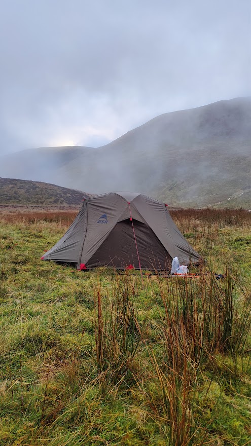
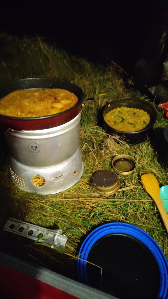
I continued up the right bank of the stream, through stones and rubble, through mud and marsh, through the outflows of strange settling tanks relating to the long-closed Force Crag Mine. I walked past the whole mine workings looking for a safe place to cross. At one point I found myself on very loose and spongy vegetation, quite possibly grown over a bog or an actual pond. Potentially lethal! I made a swift retreat. Force Crag Mine was a barytes, lead and zinc mine until less than forty years ago. It is in a beautiful location at the head of Coledale, with the dramatic Force Crag behind it. Eventually I managed to cross the stream, and had to bound uphill over steep heather to regain the path. Onwards up to the col and in no time at all I found myself a reasonably flat if not dry place to pitch my tent in the area above Force Crag. An eldritch, wild location, particularly as darkness fell. I made a good camp, had a good supper of fresh tortellini and red wine, and slept very well.
My camp above Force Crag
29/10/24
I was away from camp by 0745. It has taken me around an hour and fifty minutes from the decision to get up, to actually starting my hike timer. Unfortunately I had a wet strike – my tent was wet with dew and mist. My new Ledlenser lantern was superb, a revelation in kit. Light, small, and very bright. I walked first up through the clag to the windswept Coledale Hause – no real camping there; no water, no shelter. From Coledale Hause, to the left and south, up a broad valley to a crossroads (or crosspaths) at a gentle col. Here, turn right and uphill to Grasmoor, a tall hill (853m) whose rocky edges, such as they are, are away on the north side. Descending from Grasmoor, in thick mist, I had to resort to the compass and micro-navigation. This underlined an important principle of mountaincraft – trust the compass and not your inclination. (This does presume that you do know how to use a compass properly.) I counted paces and found where I needed to go. I would have liked to make greater use of my polythene 1:40k map from Harveys, but my path lay off the western edge of this map, and to be honest a 1:40000 map is neither use nor ornament for close navigation on foot.
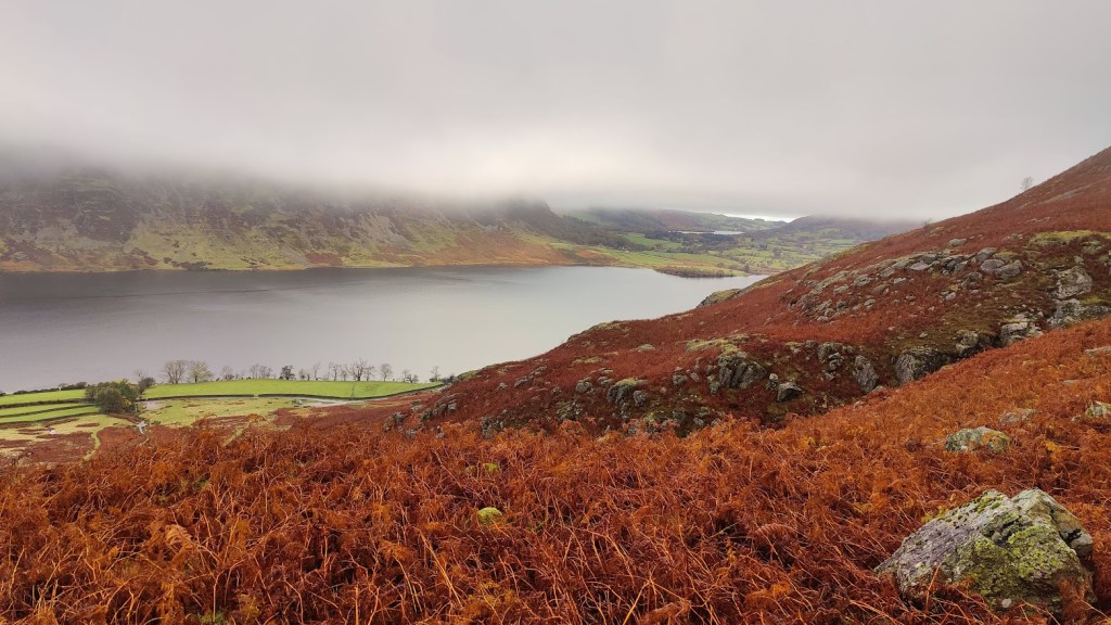
The path goes south and down the ridge called Lad Hows. At the start of the descent I happened to look round; as the clouds were thinning and sunshine was trying to peep through, I saw a remarkable sight. I saw a rainbow almost full circle, surrounding the mountaintop. I struggled to get my camera out in time; by the time I had it ready, the effect had almost disappeared. Further down, I saw a red grouse in silhouette against the cloud. It flew off. I pressed on downwards, eventually coming down below the cloud deck and seeing Crummock Water far below. I could see Loweswater, and also a distant band of light indicating that the weather was not quite as bad at the coast as it was here in the mountains. At the ford by the road I met the first of many half-term holidaymakers.
Descending to Crummock Water
Along the road for a few hundred yards, then left onto a parallel track. I was passed by two running ladies. This path was not on the map. The Ordnance Survey maps, whether 1:50000 or 1:25000, are wholly inaccurate and inadequate at this location. My route took me – this was not on the map at all – along a good path down the side of a woods (High Woods) to a stile where one enters those woods. Here I was passed again by the same two running ladies, this time going in the opposite direction. Clearly there was some kind of loop path not on the OS map. Interesting to see that the open-source maps available on the Ordnance Survey phone app, did have these paths. Onwards through some magical woods, past a boathouse. I met quite a few people and various dogs. The path led to the outflow of the lake, which is a modest dam – more of a weir, really – into which fish ladders have been built. On the other side of the dam, on a silvery grey beach, I found a place to sit for an early lunch. It was a little after 11a.m. I needed to charge my Garmin watch, which suffers serious power drain when recording a hike.
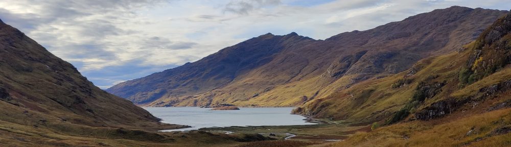
Looking up Crummock Water towards Rannerdale Knotts, the prominent mountain
I had the usual lunch: hard-boiled egg, chorizo, cheese, butter, tomato, and some pitta bread. Pitta bread was not a success when cold. Also, mini oranges and trail mix – raisins and chocolate and my own chocolate covered date/nut/seed fingers. A lot of holidaymakers passed me with a succession of labradors. Most of these were leashed or reasonably polite but one of them had to be physically restrained – actually man-handled – to keep it from sticking its nose in my bag of food. The owner’s very apologetic teenage grand-daughter, in charge of the dog (which was off-leash) was not strong enough to control it, and she was horrified by its behaviour. To those who might say that I presented temptation to the dog by having a food bag out, I say the same thing as I said to the dog…
After lunch, the path led quite literally along the water’s edge, past a pretty “pump house” (why are municipal water works in the UK almost always architecturally admirable?), and then away from the lakeside up over a hillside. I passed two black horses. Up through some more delightful woods – this was your Green Wood and Flass Wood, above High Park and Low Park farms – round the shoulder of White Crag. The path curved around to the left and south and on into Mosedale. Here in Mosedale I consciously and deliberately put in the pace, faced with the conviction that I was running late. The route up Mosedale is along a good un-made road. Later, the road ends and the path curves right and to the east, over boggy wet ground, towards Floutern Tarn.
Floutern Tarn was in the clouds, shrouded in mist and clag, and I was tired. At a rough col above the tarn, there was a straight fence marching up the mountainside. Where man can put a fence, I can walk. Oddly there was no path on the OS map, yet, today’s route, made months ago using the “snap to path” functionality in the OS mapping software, goes vaulting right up this mountainside – Steel Brow. On the ground, there was in fact a rough path. It was very, very steep and very nasty. But I am very fit and I made it to the top, albeit slowly. At the top, more marshy ground. One follows the fence more or less due SE to the summit of Great Borne, and from there, across more brown moorland over Starling Dodd and Little Dodd. At this point I was growing concerned about my timekeeping. About 2pm, I met the only other mountaineer I saw all day, a South African fellow hiking back along to Great Borne, heading for Ennerdale YHA. We agreed that I should struggle to reach Black Sail by nightfall, given that I had yet to even start along the Red Pike ridge. I thought I might even struggle to reach the Scarth Gap, and find myself benighted on the ridge. This wasn’t likely, but I was tired, and it was a grey and gloomy afternoon.
As I continued, in a patch of wet, boggy ground, I lost the path. Looking at the map, I saw that by going along the contour (level) for perhaps half a kilometre, I should reach the descent path from Red Pike down into Ennerdale. I decided instantly to get off the hill: always know when to cut your losses. Solo backpacking in late October, my natural inclination to “glass half empty” becomes mere common prudence and good mountaincraft. Counting paces, I did just that – trod level along the contour for something like 600 paces, and without difficulty, encountered the downward path. It’s worth noting that this was a combination of micro-navigation (counting paces and a close understanding of the map) with full knowledge of my location from satellite positioning. It would not have been possible without a smartphone.
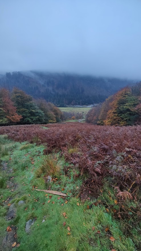
As I came below the cloud deck and saw Ennerdale below, I glanced at my watch and saw that the power was almost out. I stopped the hike timer on the spot: I had been on the hill for 7 hrs and 52 minutes. Down through a broad firebreak, a rather beautiful grove of autumn coloured deciduous trees. Ennerdale, though ostensibly the wildest of all the main Lakeland valleys, has good roads, contrary to popular understanding. It’s just that these roads are private, unmade, and reserved for forestry.
Descent into Ennerdale, dusk
I arrived at the road around 4pm. All I had to do now was peg it uphill along the forest road towards Black Sail, looking for a campsite. I had no chance of reaching Black Sail in daylight. Black Sail was over 5km away uphill, and in these gloomy conditions, at best an hour of daylight remaining. I had to work out afterwards at home where I actually camped. I needed two things: 1) running water within a few hundred feet 2) flat ground in which to pitch my tent. Running water was super-abundant; the road crossed streams every few hundred yards. Appropriate flat ground capable of supporting a tent peg – not so much. As I hiked, three or four people passed me hiking downhill with no packs, clearly on an afternoon stroll out of Ennerdale YHA. As time wore on and the light faded, and as I grew tireder, my criteria for a pitch grew less discerning. When I eventually chose a spot, it was getting on for 6pm and almost completely dark. I needed to use a torch to pitch my tent. I pitched it outer first. Whilst it was not actually raining, I was effectively in the clouds and the air was full of light drizzle. All parts of my tent were absolutely soaking wet – footprint, inner and outer. I got the inner up and had to use my towel to wipe the inside dry.
I was absolutely shattered, exhausted almost to the point of nausea. Tent up, everything inside, I was finally able to rest. My first priority was to go out again and fetch water, and then, drink water. I was concerned that I was dehydrated. Then, dry clothes, ibuprofen, and some Ralgex for my shoulder. After a while just sitting, I began to feel a bit better, and started to prepare my supper. This was red lentil dhal with garlic and onion and spinach, and some farinata – chick pea pancakes, washed down with red wine carried onto the hill in a plastic water bottle. It was a most excellent supper.
A most excellent supper
My new lantern performed well, though the limits of the battery were starting to show. It flickered several times and then switched itself to a dimmer setting. I had not bought the charging cable. No matter; the lantern is a game-changer for dark season camping, as it weighs barely 80g and is about half the size of a pack of cards. And so to bed – not long after 7pm.
30/10/24
I slept passably well. In fact I slept very well, on both nights. When sleeping on the ground (even using a Therma-Rest mat) I’m accustomed to reaching for the brufen as soon as I wake up. Yesterday it was not necessary. Today, whilst I did drop 400mg brufen as soon as I got up, it was not so much for aches and pains as prophylactic, to ward off shoulder discomfort later. I took it easy; there was no rush: I was out of my pit before dawn on a very mild morning. I had insufficient water in my tent and could not be bothered to get my trousers on and my boots on and laced up, which would have been necessary to get more water. This meant that I did not have any coffee or hot chocolate. Another advantage of eschewing coffee is that the subsequent need to make use of the sh1t shovel can hopefully be delayed until reaching civilised facilities. Unfortunately, this morning that was not possible.
For breakfast, porridge with melted chocolate and malt whisky, although I had eaten half of it before I realised I ought (at least on the hill) put sugar in it as well! This was followed by a mess of chorizo, spinach, tomato, pitta bread and melted cheese, fried in a little oil. Breakfast of champions! That said, I would not again use pitta bread and will resort to more usual western forms of bread next time. I struck camp in half light and was away hiking up the forest road before 0740. Up to within a kilometre of the Black Sail hut, there is a good road, easily passable in any car. For the last kilometre a 4WD vehicle would be absolutely necessary. This good road does belie the hostel’s reputation as the most remote youth hostel in England. Ennerdale is stupendous in its magnificent wild beauty, even in these heavily clouded conditions, and even though the whole valley is an industrial plantation. The clouds part occasionally to reveal the heights of Pillar and other peaks. Of all the great valleys of the Lakes I like Ennerdale the best; it reminds me of the music of Sibelius. I passed the Black Sail hut at 0800 hours.
A few navigational errors saw me on the path up Seary Knott onto Fleetwith – not what I wanted. I had to turn back, and I found myself wandering through a field of immense drumlins. Part of the problem is that that the path as marked on the OS map, and as it exists on the ground, is different. The path on the OS map is a straight line directly uphill up the tongue between Tongue Beck and the main Liza river. The path on the ground is a windy route up the crest of the “Tongue”. I laboured up this path into the mists, zigzagging through the grey clag, hat on sometimes, hat off when I overheated. In this mist l stuck to the path like it was my only friend. Everywhere, sheepsh*t. I never saw so many sheep, and so much sheepsh*t, as in the Lakes this Autumn. It made me reluctant to drink from the mountain streams without using Puritabs.
After a long plod uphill, I reached a T-junction; the path crossed Moses Trod, a named path weaving across the mountainside from Brandreth to Kirk Fell. Along Moses Trod, counting paces, until I reached the point where I must strike uphill, over red screes and deep in the enclosing mist, steeply uphill to Windy Gap. As I reached Windy Gap, I saw a man with a dog. This was exactly what I saw the last time I was here, in very different weather conditions five years ago. Today we were enclosed in the mist; five years ago I could see the Irish Sea. Windy Gap is a tight and narrow col between Green Gable and Great Gable. I have been here a half dozen times in my life, the first being as long ago as 1979. It was 0930 – slightly under two hours from the Ennerdale valley floor.
Some chocolate and trail mix and the remains of my water to refresh myself and onwards down Aaron Slack. At first, it is a rough but easily manageable scree, but further down it becomes a very good staircase. That said, the stone steps were somewhat slippery in the wet when going downhill. That might be a weakness of these boots. As I moved carefully downhill, four figures appeared behind me, moving very fast. No rucksacks. At first I thought they were runners or perhaps military personnel – but no, they were just young lads. I had a pleasant chat with one of them, who had the grace to dimple when I said (of my slower pace) “Oh to be nineteen”. The four of them were most polite and civilised members of the Praetorian Guard of youth, with all their lives ahead of them.
Down to Sty Head; find the tarn in the grey mist, yomp up to the top of the pass in thick clag. Then, briefly in company with four more youths, one female, I had some difficulty in this thick mist, with locating the Sprinkling Tarn path. Find out using GPS exactly where I am, then, some compass work, some counting paces, and the path was found easily enough. Onwards and upwards, now and for the rest of the hike, on strong Lakeland paths, motorways amongst mountain tracks. Halfway up I was pausing for breath when I was surprised and a little mortified to be overtaken. I was overtaken by a substantial (at least a dozen) party of what looked like U3A hikers to me, not one of them except their leader a day younger than I, and all (except for their guide) carrying tiny knapsacks. I was hauling probably 18kg of wet expedition bag, and had hiked 45 km since Monday lunch time. In fact, starting off again, I kept pace with them and started to overhaul them, but they turned off to the right into the mists.
At Sprinkling Tarn, though it was barely 1100, I stopped for a very early lunch, sat in what little shelter I could find by the brown moor, the steel-grey rippled lake. The clouds lowered. I pushed on, passing through an area where clearly there had once been a tarn. The geography was all corrie, though the only trace of dried up lake was the colour of the grass and a marshy area. Up to a broad col where going wrong would have taken me up to Esk Hause, which was not at all necessary today. Esk Hause is that spot in the Lake District furthest from a metalled road. It’s about 2.5 miles to Rosthwaite in Borrowdale, to the Wasdale Head Inn in Wasdale, and about the same (using Rossett Gill) to the Dungeon Ghyll in Great Langdale – my final destination today. Coming down from the col I passed two young people, a man and a woman, working on some repairs to the path. And so by degrees down to Angle Tarn, my third and final grey lake in the clouds of the day. Styhead Tarn, Sprinkling Tarn, Angle Tarn. To think we camped here when I was but 16! What were we thinking of? In warm and dry conditions, fair enough. In wind, cloud and wet, not so much.
In all this hike there has been no actual rain at all, and it has been mild to a remarkable degree. The wind has not risen so much as to rattle my tent. I could have done with some wind to cool me down, dry my sweaty clothes and dry my tent. I wore gloves for perhaps 5% of the time I spent hiking. From Angle Tarn, along the contours or perhaps slightly uphill , to the right of Lining Crag, and thence down, below the mist line, to the “Pile of Stones” at the top of the Stake Pass.
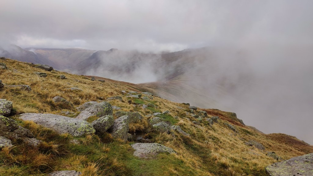
The top of Stake Pass seen in the distance as the mist clears
In effect, job done. It was just around 2pm. Downward then, along a good staircase down into Mickleden, and then along the flat of Mickleden to the Old Dungeon Ghyll Hotel, whence I arrived, tired and footsore, a little after 3pm.
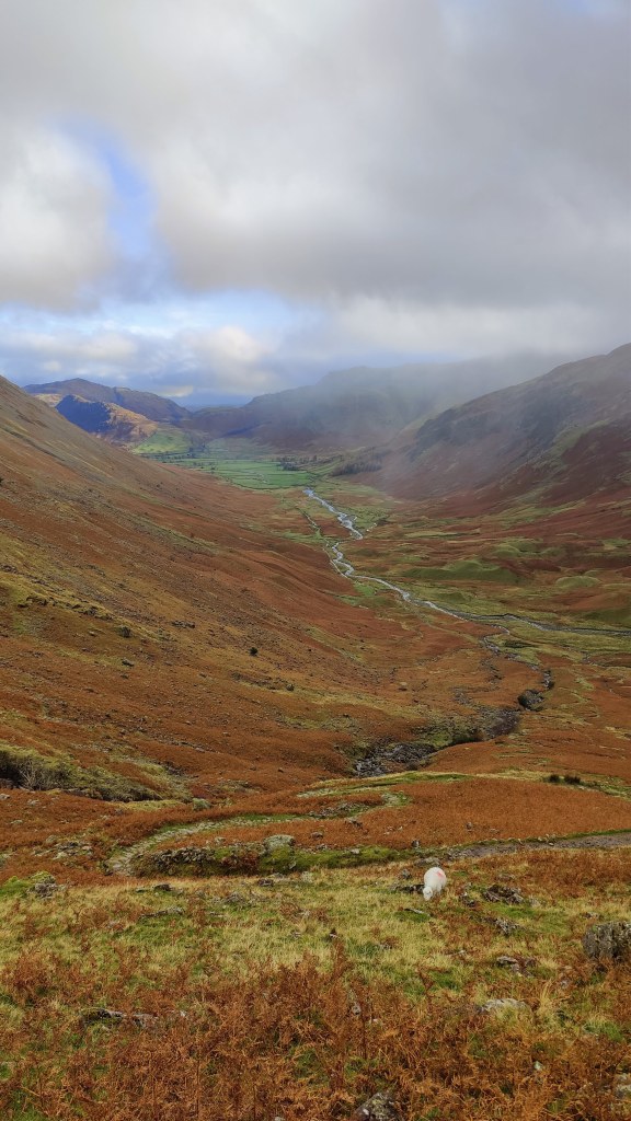
Mickleden, seen from some way down the Stake Pass
I hiked a little over 55km in three stages over a little less than twenty hours. From Keswick to Pudding Beck was 9.7 km over 3 hr 23 minutes. From Pudding Beck to my camp in Ennerdale was 26.4 km in 9 hrs 16 minutes, finishing after dark. From Ennerdale to the Dungeon Ghyll via Sprinkling Tarn was 19.4km in 7 hrs.
A review of “A fiery and furious people – a history of violence in England”, by James Sharpe
Take that! Blam! And that!! Oww!!
I saw this title a good few years ago and I thought, that’s one for me, that’ll be interesting. Are we English violent? Are we more violent than other races? Is it our Anglo-Saxon or Norse heritage? The Duke of Wellington famously said of his own troops that they were the “scum of the earth”, and it is possible that propensity to violence does make for good soldiers. One feels that crossing the street to avoid soldiers need not be completely unnecessary. The purpose of soldiers, after all, is to visit physical violence on others, hopefully, but not always, other soldiers.
James Sharpe traces the social, cultural and legal history of violence from the Middle Ages to the present. It’s mostly readable, although there were a few sections I had to skip, particularly the section about serial killers. Not because I’m particularly squeamish, but because the work in those places was in danger of being about crime and legislation, rather than violence per se. That said, you can’t today discuss violence without discussing crime and punishment, and that, of itself, is an important finding of the book. What passes for violence has changed through the ages. The degree and type of violence that the common people, the law, and indeed the State, will accept or put up with, and where the line is to be drawn, has changed much over time.
Sharpe has chapters on various themes, as well as moving in a logical way from the past to the present. He covers violence in the middle ages, where he draws in the influence of the Norman French feudal aristocracy and the effect of the concept of “Chivalry”. He covers dueling, and domestic violence, rape and sexual violence, and also serial killers. Of families, he notes: “It was only as feudalism succumbed to capitalism, and a traditional, community-based kinship dominated society started to give way to one in which individuals began to come to the fore, that the family as we understand it today, emerged”
He does note that most (although not all) violence is visited by men, and mostly, to be fair, on other men. It is men who are violent. Aggression plays a part. I’m reminded of Sebastian Junger’s excellent book “War”, about the young men fighting in Afghanistan. Here, we read of the importance, particularly for young men, not of war as such, but of combat. Most men understand this instinctively, even if today, that combat is no longer always physical.
Alas, he does not mention the story quoted I think by Churchill, that the Venetian Ambasssador was so intimidated by the physical presence of Henry VIII that whenever he was in that king’s presence, he never stopped worrying that the king would actually lay hands on him and do him violence.
Several more important conclusions are drawn. We should be careful of the danger of reading too much into crime statistics (or any statistics). Reporting of violent crime is not the same as violent crime. An example of this is the suggestion (reasonable certainty, really) that some police forces today – as in the past – do not have the funding to prosecute as many violent criminals as they otherwise ought – which will affect crime figures. Prosecuting people is expensive. Another: our world and the people in it are very much more complicated than it would appear from social media or from the pages of the Daily Mail. The nature of violence is changing; I don’t think it is getting less, although our tolerance of casual violence is lower than it was – just as it should be.
We come into a world now where social violence – trolling, online bullying etc – may need much more tightly regulating: because who needs a judge and jury when you’ve got Facebook?
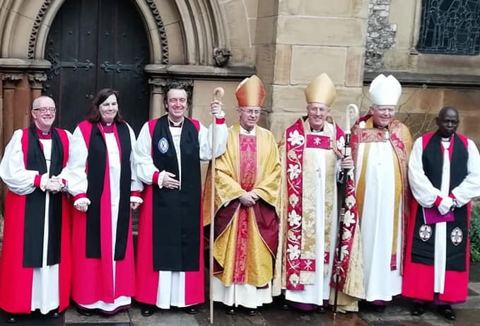
In posh frocks and best suits, we took train in the rainy morning up to London Bridge. It was that kind of fine rain that gets you wet. The event we were invited to was not a wedding, but it proved to be more like a wedding than anything else. We were going to Southwark Cathedral for the Ordination and Consecration to Bishop of our friend and former rector, the Reverend Doctor Andrew Rumsey.
At the cathedral we took coffee with a lady we know who must use crutches to get about. She bears considerable pain and disability in her life with a very English stoicism and understatement, and she often looks rather tired and drawn. But today she had battled through on her crutches and was looking very well, pushing the boat out to join in this important celebration.
And then we were all seated. There was a short warm-up act, a deacon or dean or some such, who made everyone laugh while explaining how things would go during the service. In a more secular gathering, he would have been the person who had to start his short speech by saying “There are no planned fire drills today”.
Then there was a procession. There were dozens of richly robed prelates and lords spiritual. Bishops, deans, deacons, priests, acolytes and singers. A number of people carrying shiny sticks, or candles, or holding up Bibles. And amongst this procession, all our clergy friends. In all this colour, pomp and pagaentry, a connection to people we knew. A young priest I know touched my shoulder as he walked past. Hey Nick!!
The final person in the procession was the Archbishop of Canterbury, who took the service. Our former vicar was presented to Canterbury by two mentors, one on either side: the Bishops of Salisbury and Southwark. Questions were asked, “Do you believe him to be of Godly life and sound learning?“, using a form of words that must be centuries old.
Canterbury went on to cause a clerk – “the Provincial Registrar” – to read out the whole of the letter of authorisation for the ordination of a Bishop – the letter patent. Here was language linking the everyday of the here and now, to the sweeping arc of history; here were words from the seat of power, from the Queen herself, relating to someone I’ve sat and had a pint and peanuts with. Just remarkable. One might feel part of a nation, tribe or group as it exists across the land today, but less often, perhaps, might we feel that sense of belonging across time, stretching back through the generations. And listening to this letter being read out, we were all part of Merrie England. Someone else deserves the credit for saying this, but there is hope for Merrie England when people like Andrew Rumsey are appointed to posts like this.
The sermon was given by the Reverend Canon Chris Russell, the Archbishop’s Adviser for Evangelism and Witness, and parish priest in Reading. And what a sermon! Of the art and craft of sermons, my old vicar used to say, “always start with personal stories”. Chris Russell did just that and took us from the inessential (in his family’s case, a shower head that lit up) to what we really need. What do we really need? What do we really want? What MUST we have? God’s call on our lives: all of us are called by God personally, and by name. We are called by name because we all matter, each and every one of us. God has questions for us, which must be answered – again, because we all matter to God.
Later on, the college of Bishops laid hands on their new colleague Andrew at the actual moment of his ordination. There were dozens of them; not all could get near him. The further away Bishops laid hands on nearer Bishops who in turn laid hands on Andrew. To see this very physical act, this laying on of hands, right at the pinnacle of the Anglican establishment, was a remarkable sight. History, tradition and the teaching of Scripture brought right into the present. The laying on of hands is a common enough practice in house churches and in Charismatic churchmanship, but perhaps less common in the grass-roots Church of England.
There was a giving of appropriate and symbolic gifts. A Bible, a ring; a cross, a crozier – all the “stuff” a Bishop might traditionally use to exercise their office. A word on the crozier. My wife organised that. It was again, a moment of connection. We’d driven across all England, all the way to a former mining village near Durham to collect this fine piece of work, which was now in the hands of the Archbishop of Canterbury. A craftsman by the name of Tom Keers made the Cleek (that is, the curved part made of horn at the top) and another, named Roger Marwood, made the shaft of oak- from Acstede – “the Place of the Oaks.” Both will be proud to see their work in such hands.
And then it was over: the rector was become a Bishop. The gathered prelates and lords of the church started to process down the aisle with their newest colleague among them. As they did so, there was a spontaneous round of applause and cheering for Andrew Rumsey, which he acknowledged with a smile. It was another human moment in a big, portentous, important occasion when powerful forces for good were at work.
As the procession of lords spiritual, prelates, clerks, singers, acolytes and men carrying shiny sticks made its way out, I saw the Archbishop of Canterbury stop, greet and touch fists with a ten year old boy, who like me, had an aisle seat. Canterbury didn’t need to do that. In doing so, in stopping to greet that lad, he made his day. And mine too.
The train hisses through anonymous railway stations and anonymous towns. The stations fly past to quickly for me to catch their names. The towns? Houses and streets, industrial units, perhaps the odd ancient church standing out through the early morning mist.
Across the heartland the train goes, through the very essence of middle England. You don’t need to know what the names of the towns are, to know what they are like. The rails shine with use; the electrical wires and their supporting posts flash by. In the distance, green fields and hills under an early morning sky of pale blue. The molten sunshine of not long after dawn washes everything clean. It all looks idyllic. Frost-covered green fields, patches of ground mist.