From Newtonmore to Fort Augustus via Laggan and the Corrieyairack Pass

After work, in the afternoon, to the shop to buy various bits, and then pack a bag. The rucksack, which had been 13.9kg with equipment less about two kilos of batteries, Kindle, notebook and pens and trail poles, was 22kg on the eve of departure – all up: all clothing, all food, and some water. Heavier than I anticipated, but manageable. Where had that weight crept in from? This was to be my ninth solo backpacking and wild camping adventure. To Cromford then, and by train to London.

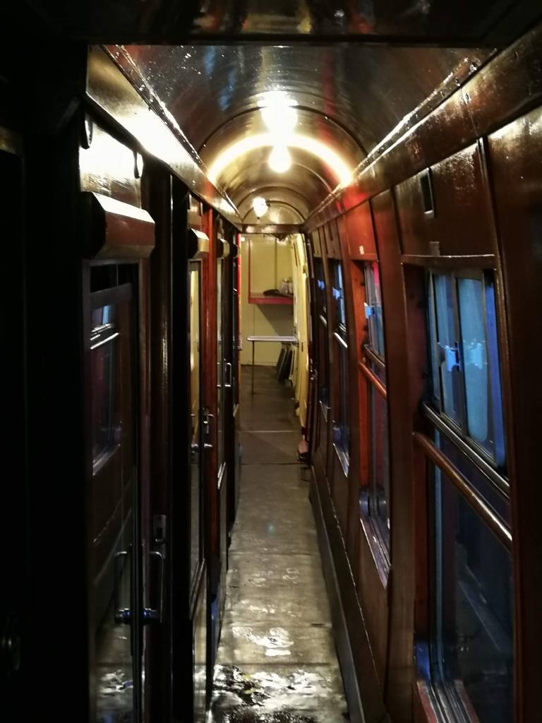
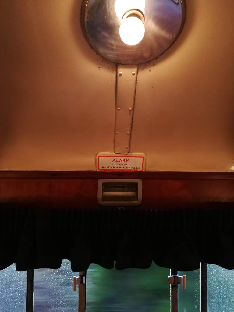
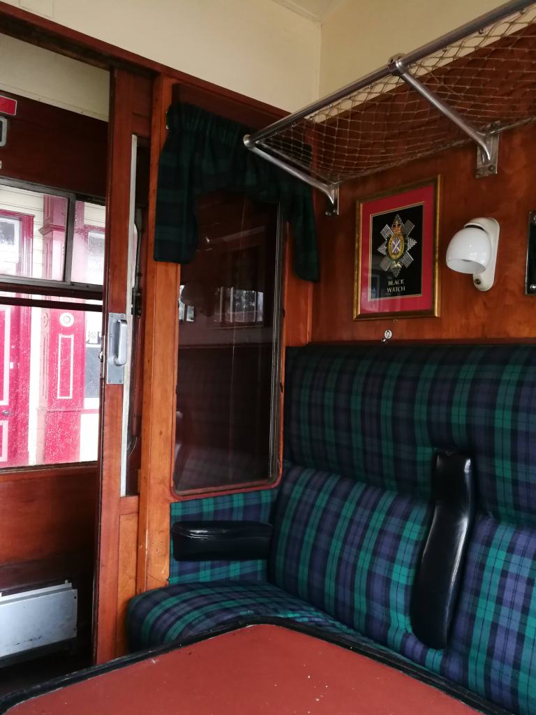
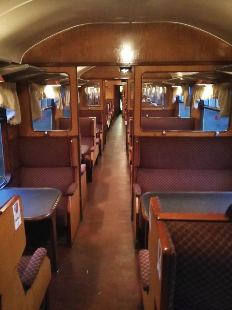
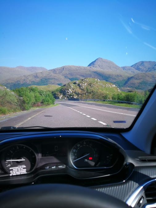
Arriving in London I had a bit of time – trains in the UK are just not reliable enough to cut things fine and not leave plenty of time. I was at St Pancras at 19:38 for a 21:15 train out of Euston, up to Scotland. Why was I travelling from the Midlands down to London to go back up to Scotland? Because the alternative was taking the train to Crewe and picking up the sleeper there at midnight. If you’re going to wait for a couple of hours on a draughty railway station platform at night, I don’t recommend Crewe. I did that once; it won’t be happening again. I had a pint and a sausage roll in the Betjeman Arms at St Pancras, then strolled along the Euston Road to join the sleeper to Inverness, the longest train in Britain, and my carriage right at the front of the train.

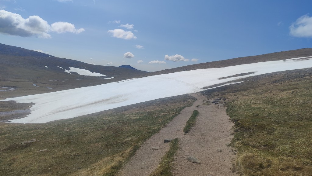
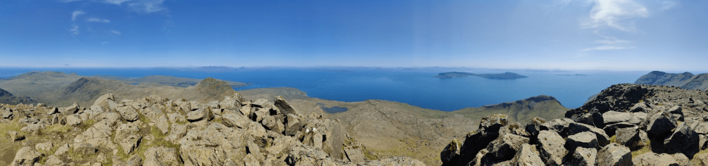
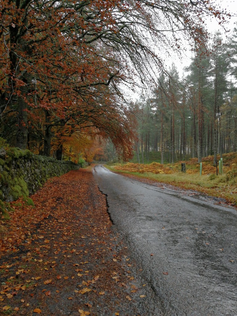
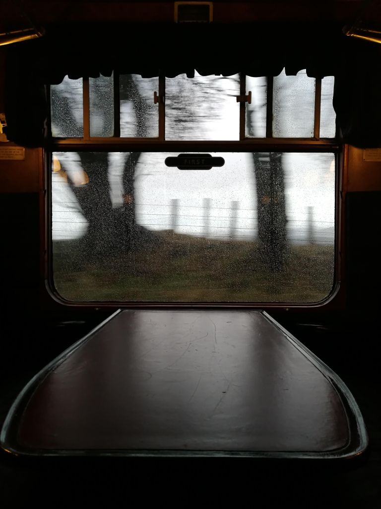
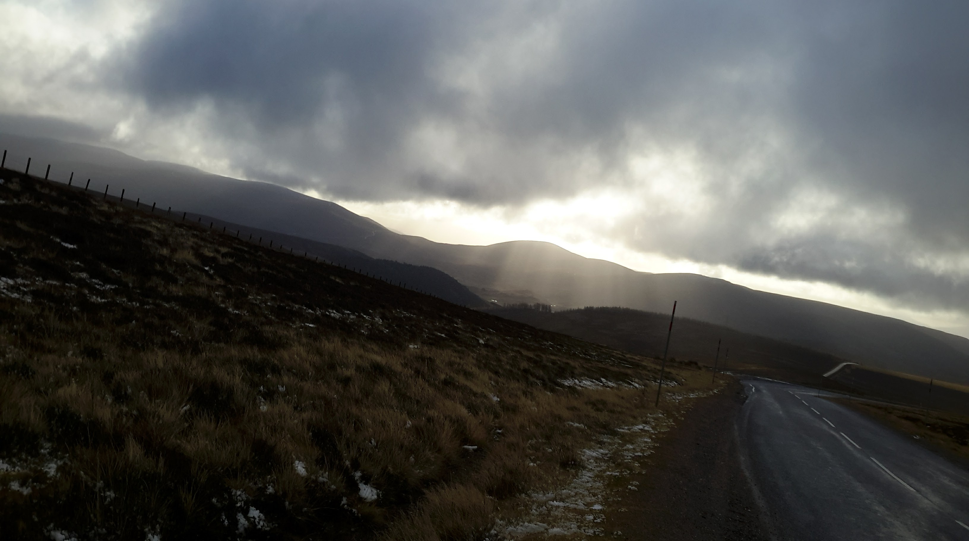
I slept well enough on the train and had to hurry through my full Scottish breakfast in a paper bag. I found myself on the platform at Newtonmore at 07:15 on a drear and misty morning, barely starting to get light. I dragged on everything I had, to keep warm, and in Goretex over-trousers, gaiters, waterproof jacket, gloves and woolly hat, set off into the pre-dawn gloom. I had in reserve only a thin Rab mid-layer and at that point in the morning wondered if I had come onto the hill ill-clad. I walked out of town up onto the heath; had there been no mist this would have been glorious and scenic. You could tell it was a temperature inversion – there’s a look about the sky when you can sense that radiant blue sky and sunshine are only inches, as it were, above the steel-grey ceiling of mist.

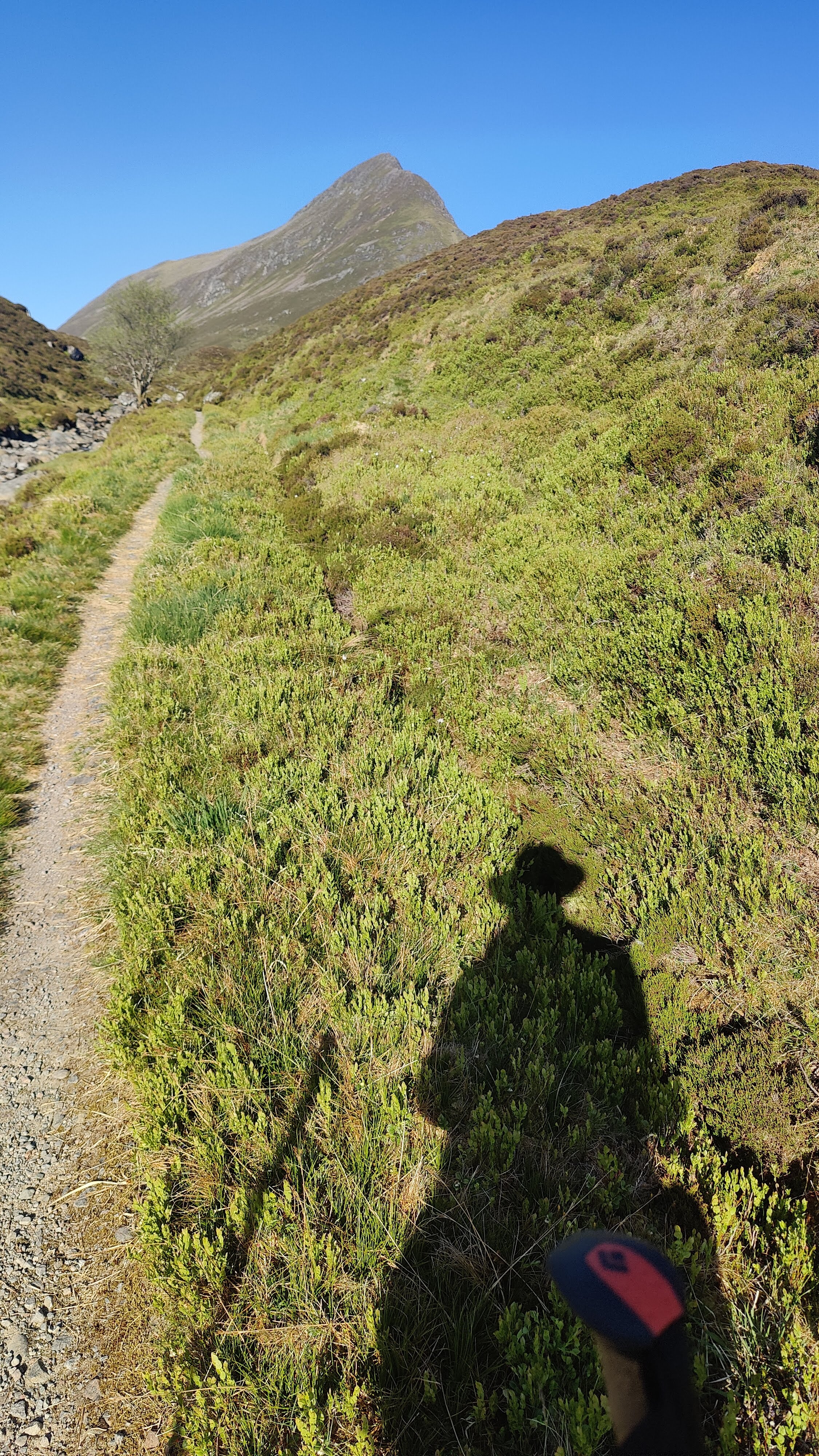
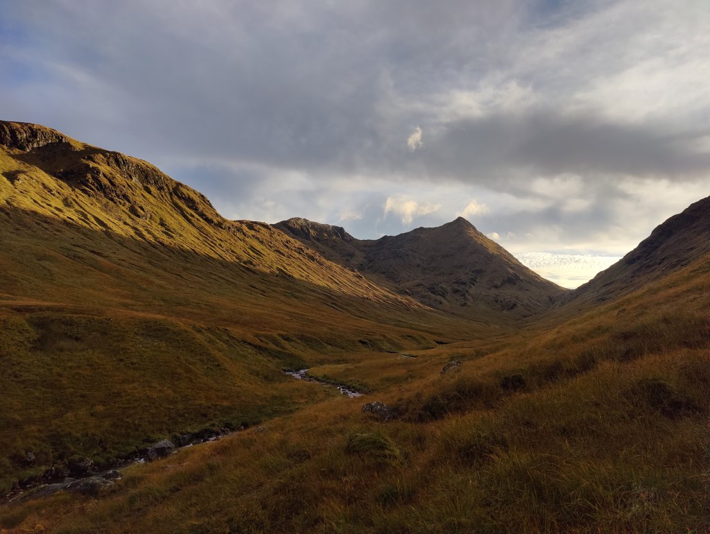
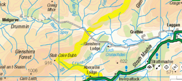
I ascended the Calder River up Glen Banchor, meeting no-one, listening to the fearful noise of stags rutting. This noise reminds me, with my taste in films, of the zombie apocalypse. At one point I needed to take care fording a stream. Late morning, I was approaching a tin hut somewhere round 648984, where the map marks “township” at Dail na Seilg. A stalker strode out to speak with me. We had a polite conversation about my plans, and his plans, and I saw that I needed to change my plans. It suited me to do so, to be fair – it wasn’t simply a matter of me rolling over. That said, this is pure stalker’s country, not at all walker’s country.  I followed a tired old land-rover trail and became aware I was going in the wrong direction. I was soon lost and disoriented in the brown upland, stumbling over the heather looking at my compass. It took some close map and compass work to get me onto the right trail, a good and substantial unmade road, which I followed south-west down Strath-an-Eilich.

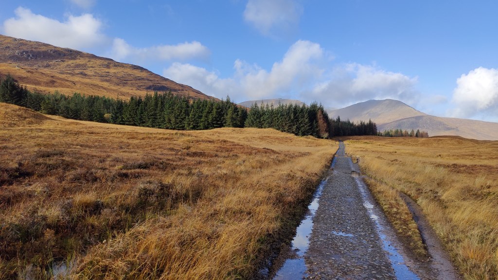
Early afternoon I came out at Castle Cluny, a nice-looking Scottish Baronial pile in the usual grey granite. Through the delightful autumn colours I trod through the grounds out onto the road. Without a detour, there followed a tiresome 2.5km tramp along the A86, a single track road at this point, but still with a fair amount of traffic. This brought me to Laggan, around about 3pm. From here, another tarmac road tramp of 4.5km brought me to the “Spey Dam”. I had not been aware I was walking up the Spey valley. I met no mountaineers or walkers. At this point, around 4pm, I’d been 7-8km on metalled roads and much of the rest of the distance on good unmade roads. I admit that had I known so much of this route lay along actual roads, I might have chosen differently.  

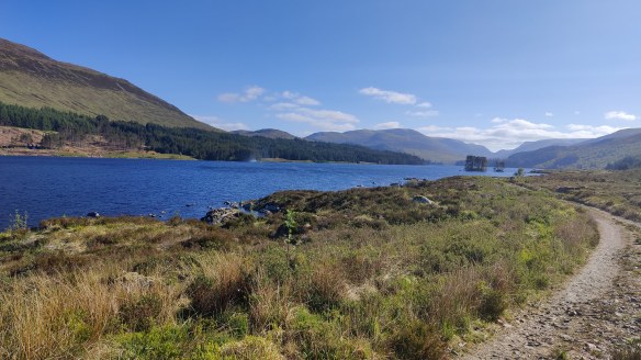
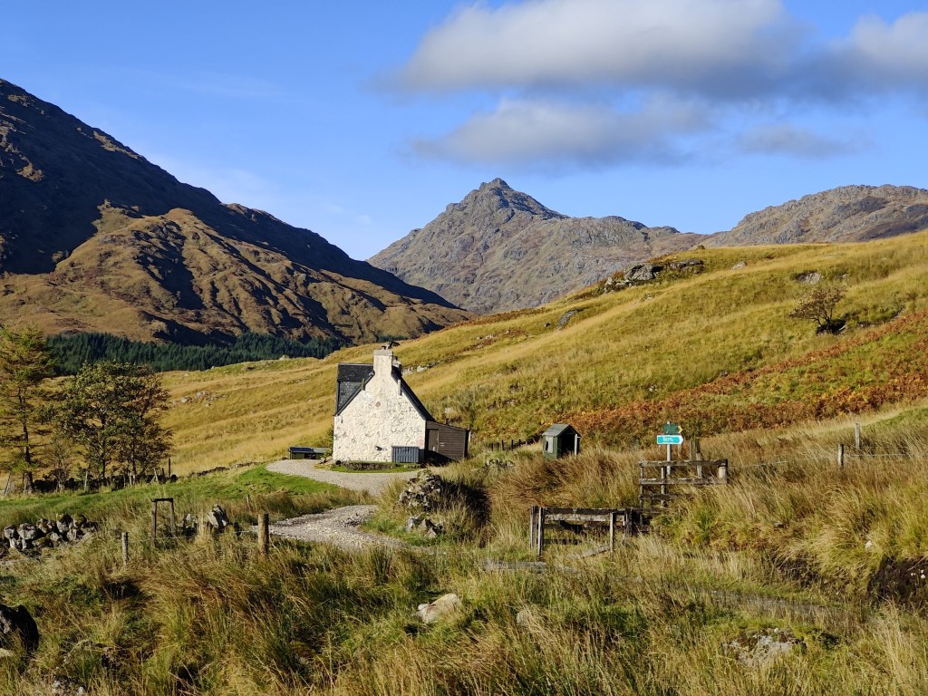
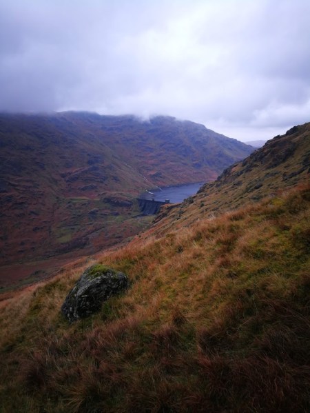
Resting by the dam, I saw a couple of cyclists whizz past. I set off along the road under the dam and arrived at a kind of industrial yard, with piles of rubble and hardcore, and big spotlights ready to be connected to a generator – there’s no mains electricity here, even though this countryside isn’t the ostensible wilderness of the Cairngorms. All around there are very robust and well-maintained deer fences, with proper access for vehicles and pedestrians at the appropriate places. At this point, early though it was, I was looking for a place to camp. I could continue along the unadopted and private metalled road along the north side of the reservoir created by the dam, or I could hike uphill into more wild country further up Glen Markie. I opted for the former. I went through a metal gate, pulling back the bolt. The bolt made a displeasing sound that in the pristine silence of that place, sounded like a lamb being slaughtered. I walked a hundred yards before repenting of my decision and turning back. Such sudden changes of mind have served me well in the past. Being willing and able to change your mind is a virtue, not a vice – don’t let anyone tell you that stubbornness is a virtue.

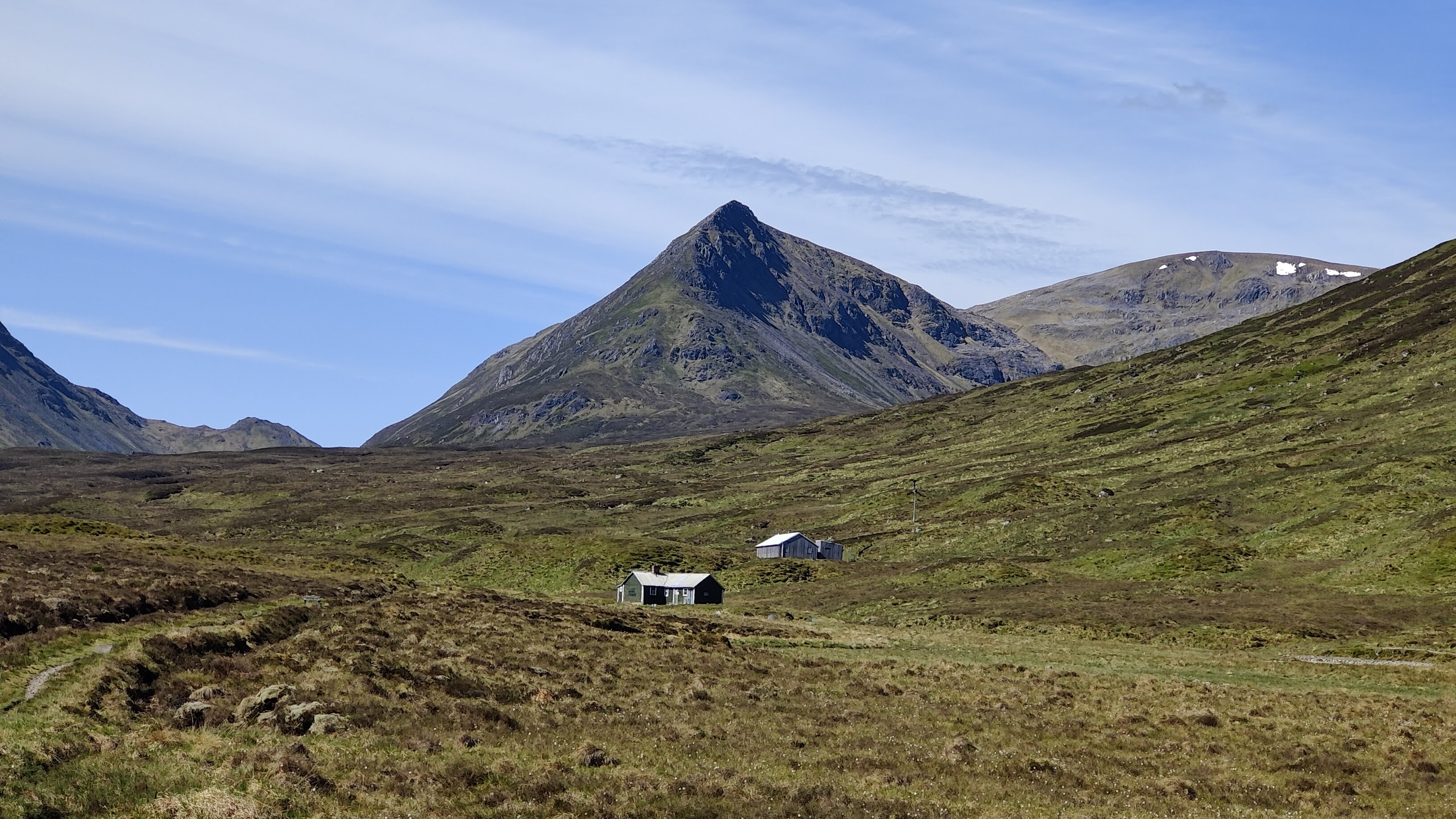
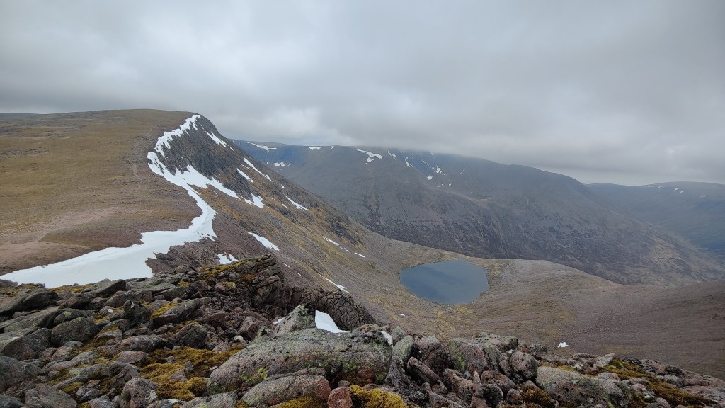
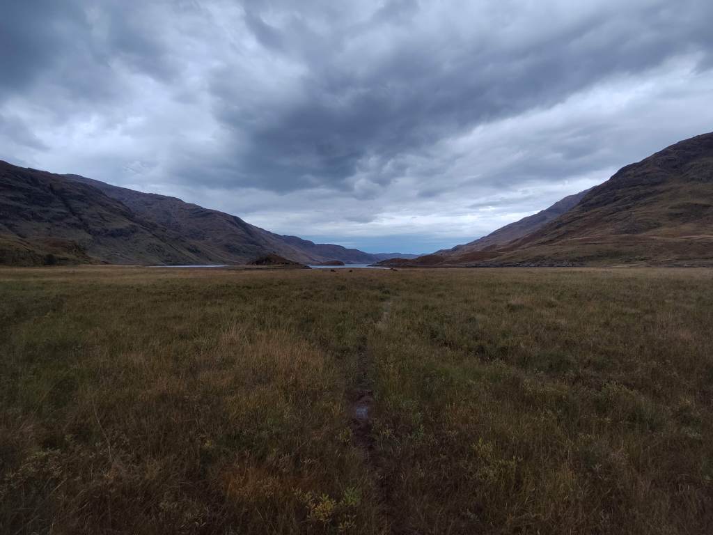
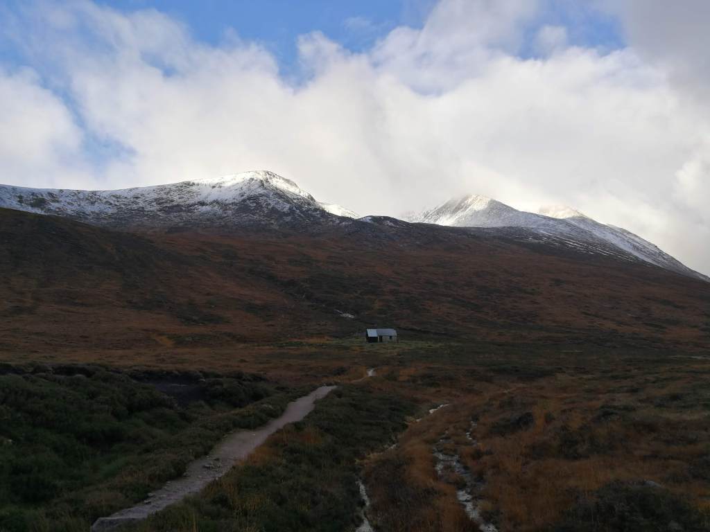
I detoured uphill into Glen Markie for about an hour, past a wasteland of industrial plantations, until I came across a place where I might camp. I would have to hike back downhill to the reservoir tomorrow morning, but this was more or less where I thought I would end up when planning this trip as a desktop exercise back in June. I camped near the ford of the Allt Tarsuinn Mor, just before it joined the Markie Burn, a substantial river. I had a very cramped and limited pitch, but it had the advantage of being bone-dry heather. I was just below the tributary stream as it flowed down a ravine into the main river. I could hear running water in three different registers: the roaring or rushing of the river, the chuckling of the brook over stones, and the sound of small waterfalls. In spite of the limited pitch, it was supremely comfortable and I took one of the best nights’ sleep for some years, from around 7.30p.m right around until well after 6.30a.m next morning. I had a completely dry strike and was away from camp around 9 o’clock. There was no hurry. In any case, at this time of year in this place, daylight comes late and lingers late. There was little usable daylight much before 7.30a.m.

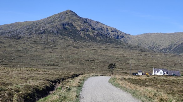
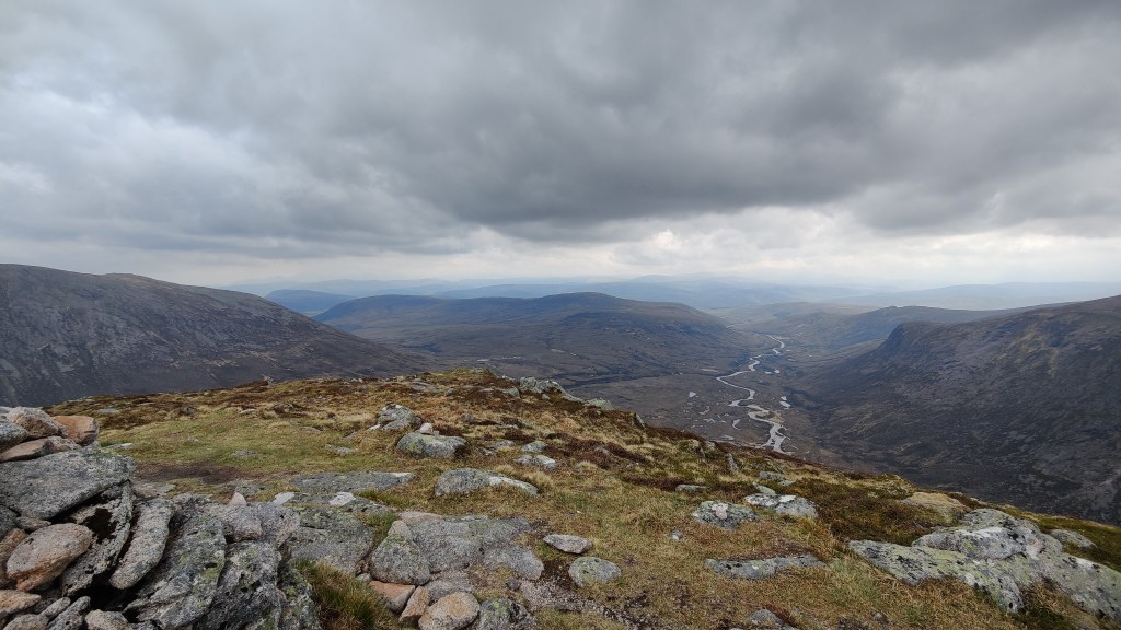
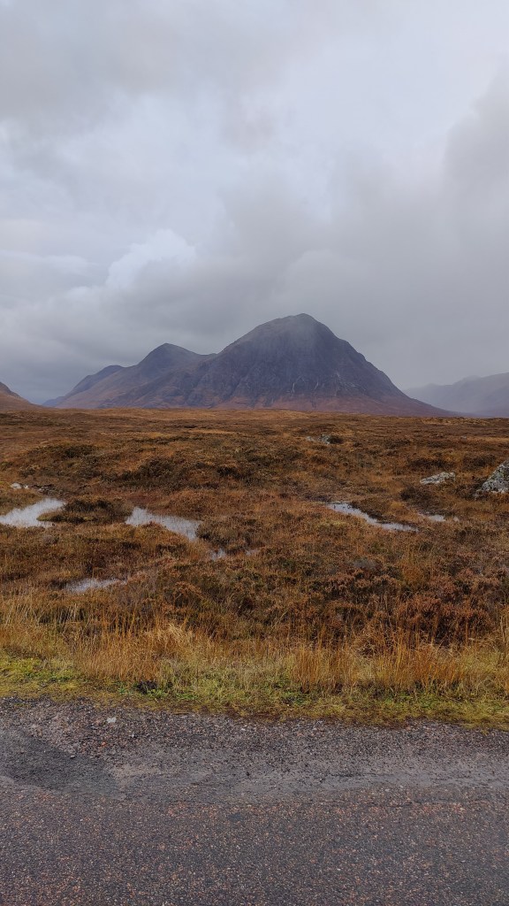
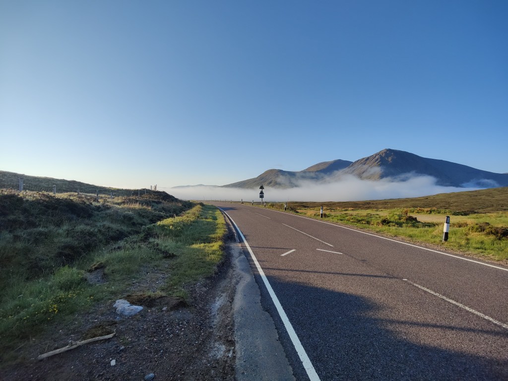
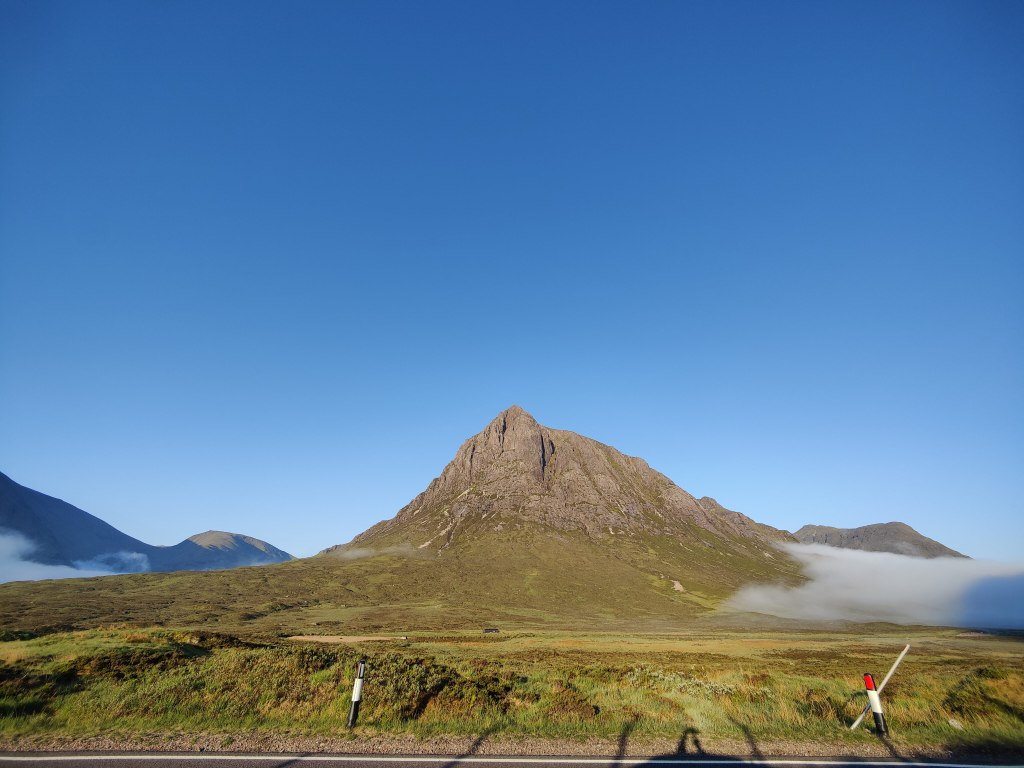
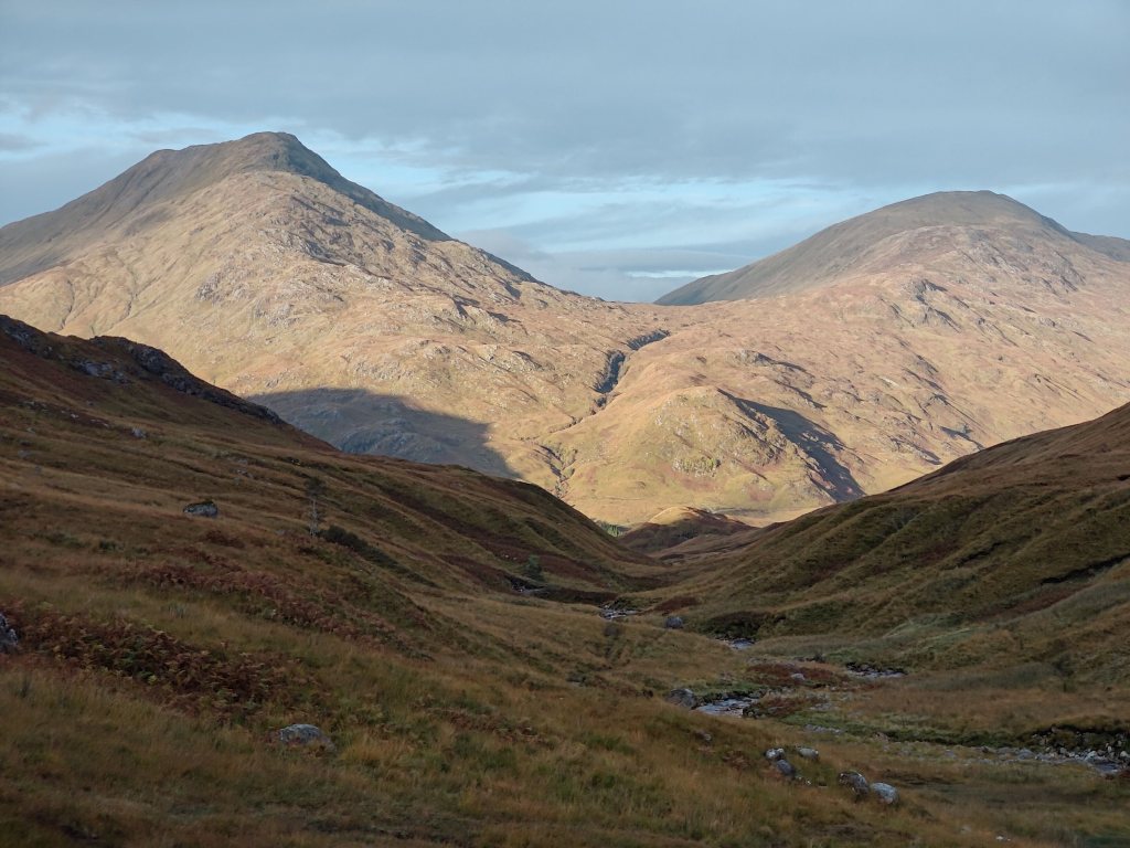
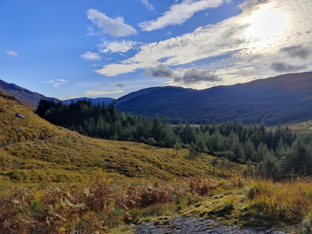
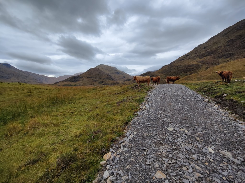
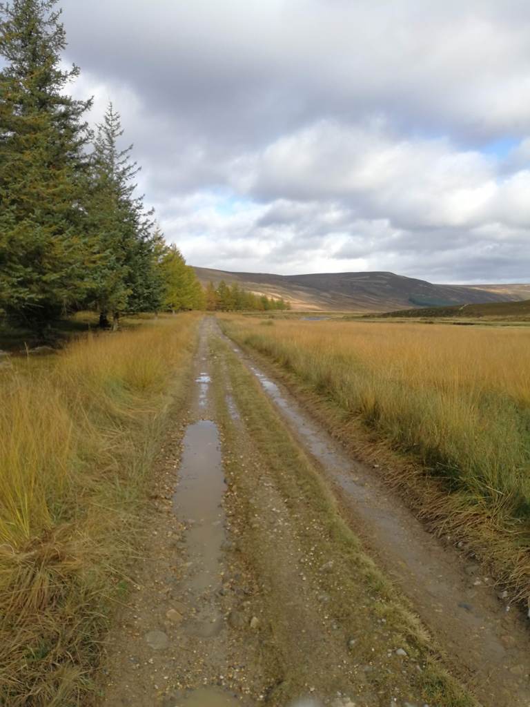
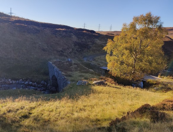
I hiked back down to the bottom of the glen, and turned right, resuming my route of the afternoon before. There followed 12km along metalled road – a single track road through glorious, empty country – but a metalled road all the same. The adopted part of the road (that is, the part coloured in yellow on an OS map) ended at Garva Bridge. Here there was an ancient bridge of 18th century military origin. Two cyclists whizzed past. I stopped for lunch and sat between the road, the woods and the Spey, under the cathedral of a clear blue sky. Today’s weather was better than yesterday’s. The tarmac gave out at a place called Melgarve – an empty house. At this point, in the heart of the Monadliath, you’re about 16km from the main road at Laggan, and perhaps a little further from Fort Augustus.

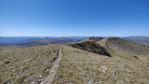
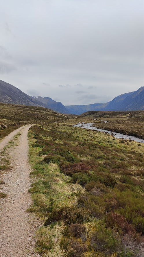
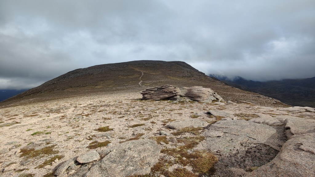
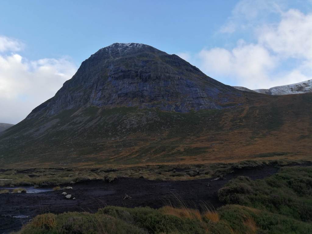
Beyond Melgarve, first a very conspicuous “Road Closed” sign, secondly, an actual half barrier blocking the way ahead to vehicles. The road itself continues up into Corrie Yairack, though without benefit of tarmac. This is one of “General Wade’s Military Roads”; to walk this route is why I was here. The afternoon’s walking ahead of me was the crux and heart of my trip.

Corrieyairack Pass

To the chagrin of some, a mighty high-tension power line marches up the valley, into the corrie and up and over the pass. All should have access to electricity. I remember in the 1980’s hitch-hiking in the Lake District and getting a lift from an estate agent. He told me that the Friends of the Lake District – every one of them living in a home with electricity – had opposed the building of power lines over a wild valley, which would have brought electricity to houses that did not at that time have access to power. Ever since then I’ve had little patience with the sort of environmentalist who sits in comfort opposing construction that would being the same comforts to others.

One of General Wade’s original bridges

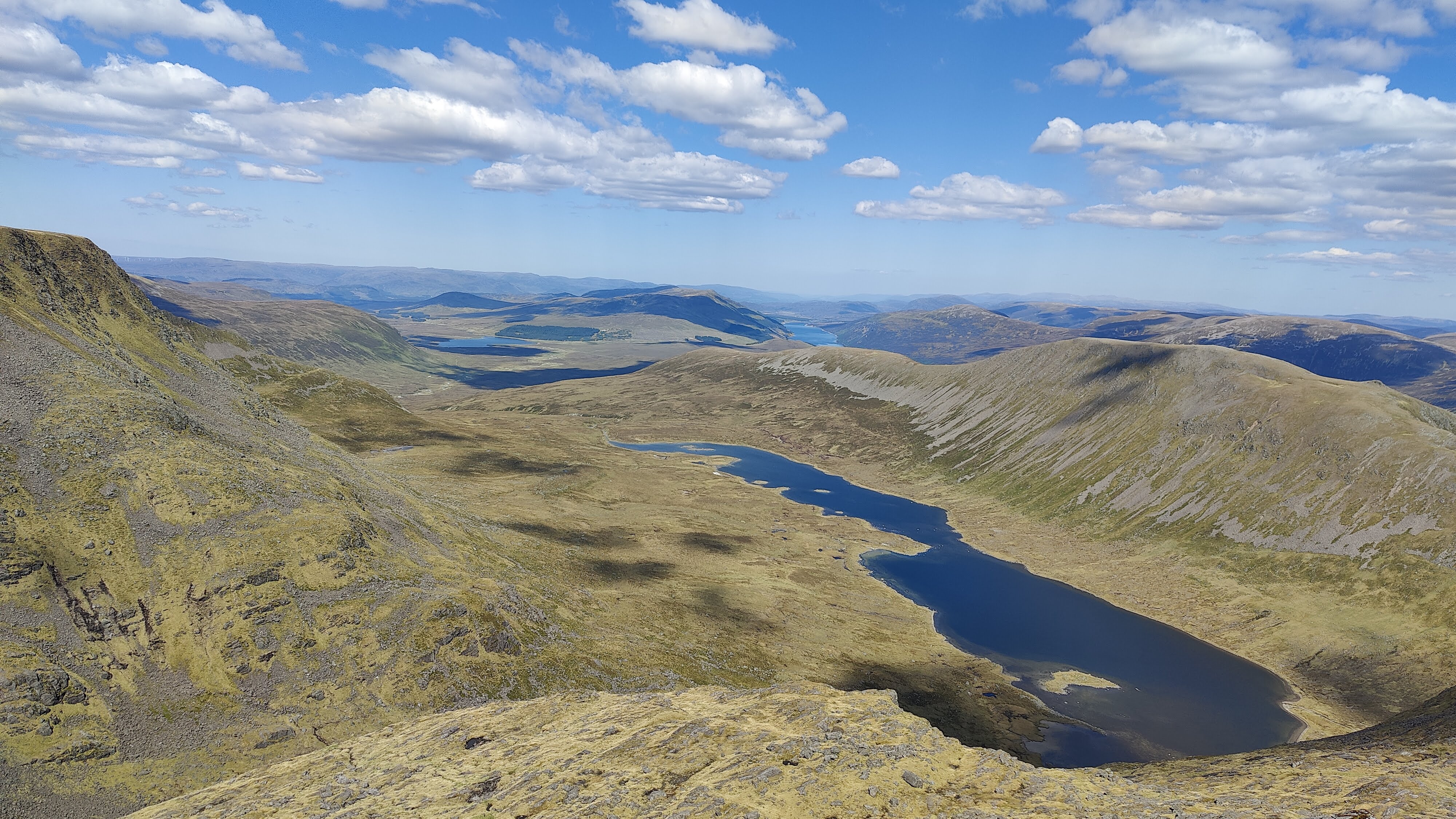
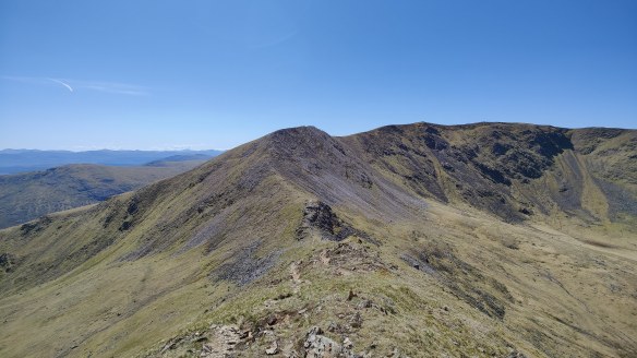
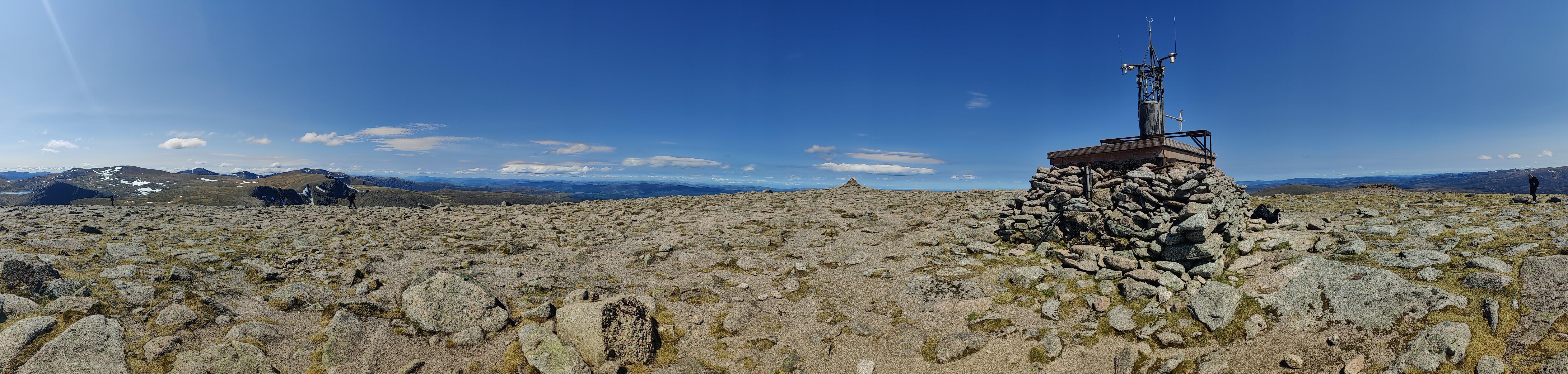
Near the foot of the pass proper, I met a cyclist, the first outdoorsperson I had spoken to in days. I had seen no walkers, nor even so much as a footprint, along this route. The crux of the pass was six zig-zags, six legs of which were at this time of day (mid-afternoon) walking directly into bright sunshine. I was bareheaded. I had not thought to bring a sun hat, though I did have sunglasses. I blazed up the zig-zags barely out of breath. I’ve had eye trouble this year, and for that reason I chose this route because it was not so physically challenging. I also reflected that I have become successively more physically fit, particularly upper body muscle tone, on each one of these nine solo camping expeditions I have undertaken since 2021. I came off the hill on that first trip and had some unpleasant muscle problems in my shoulder, and had to visit a sports physiotherapist at the cost of several hundred pounds. Since then, on the advice of the physio, I try to do regular upper body strength exercises. Coming down to the Dungeon Ghyll last October, after two hard days on the hill, I was absolutely shattered – and part of me, misses that feeling. Being immensely tired sharpens one’s appetite for the simpler comforts in life –a hot shower, clean clothes, a Nice Hot Cup of Tea, a pint of beer and a pie, a warm bed.

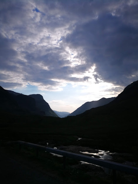
At the top, a squalid guard-house stood, with an open door and bunks visible inside. In the long and golden afternoon I followed the path down towards Fort Augustus. I passed a 4WD vehicle with three fellows in it clearly observing deer. Another thing I noticed which I found unusual, was overflight by a small fixed-wing aircraft – repeated overflight, three or four times. Helicopters would be unremarkable, but a light aircraft, I found unusual: this is wild country. It was certainly not a sight-seeing flight. Far more interesting and dramatic mountains are available within a few minutes flight time for even a light aircraft. My best guess, looking at the heading and direction it was taking, was that some form of commercial survey was taking place, probably of the power lines in the valley.

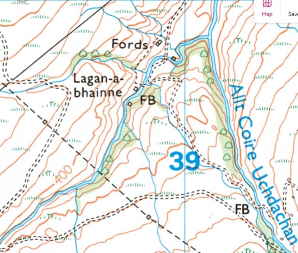
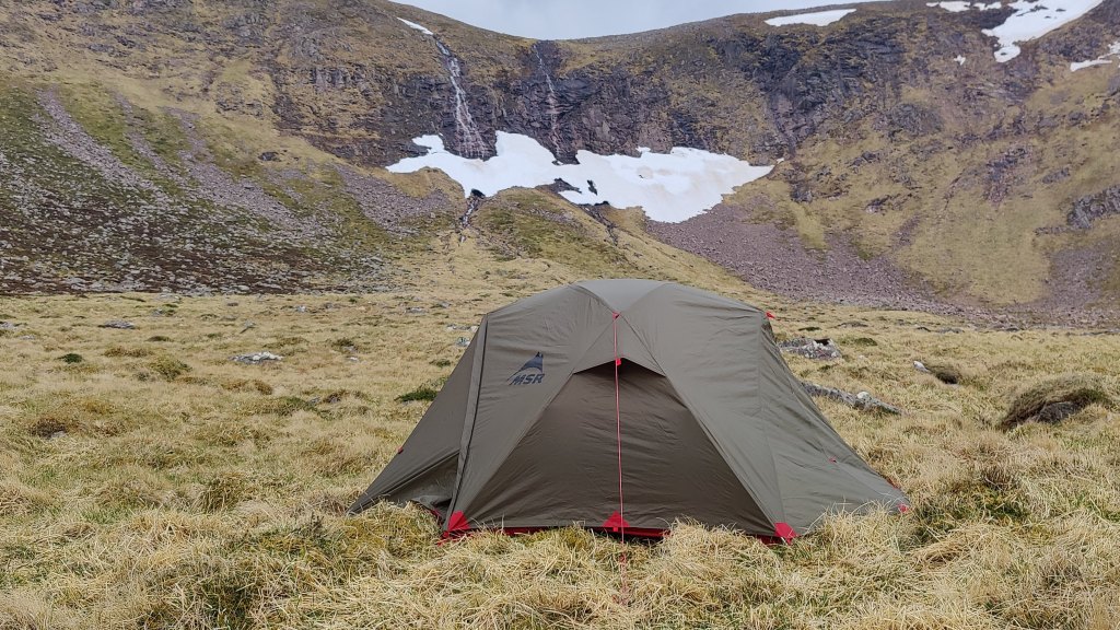
It was my intent to camp at a place called Lagan-a-bhainne, a wooded area of small valleys about 12km out from Fort Augustus. Still in the wilds, but off the high moors. When planning the trip I had spotted the area and thought it looked like a likely spot for a wild camp. My eye as someone with some experience in map-reading, was drawn to it. As on the map, so the reality on the ground: it was indeed a quite magical area where a narrow wooded valley cuts through the high moors. I found a spot to camp, taking quite some care that my tent could not be seen from the dirt road: it seemed to me that the three men I’d seen earlier would be employees of the landowner, and they might be driving through later on. Unlike in England, it is still perfectly legal to camp wild in Scotland, but why draw attention to yourself?

This was my second night by a babbling brook. I find the sound thereof, very restful. For supper I had my usual Indian: a spicy red lentil dhal, chick pea flour pancakes, and fresh spinach, all washed down with about 200ml of rather nice Shiraz. I always say, wild camping does not mean roughing it. Wild camping – any camping for that matter – is not, for me, a means to an end (as in merely low cost accommodation close to the mountain), but an end in itself. It is time spent alone outdoors, time spent in the wild countryside, time to collect your thoughts and prayers, time to be still. I came away carrying probably 22kg, of which 3kg was food and drink. I was not troubled thereby.

Interestingly, though I had picked a reasonably flat place to pitch, I could not settle comfortably at all – there was incipient backache, tossing and turning whichever way I lay. I moved through 180 degrees and slept like a baby. I woke up around 0600, which is too early at this time of year and latitude – there being another ninety minutes of darkness. But I was awake. I got up and prepared for my day. I had a breakfast of champions – cubes of bread, cubes of cheese, and chorizo sausage, all fried in a little olive oil and butter. Porridge of course. Black coffee. I did not have a dry strike, but it was a lovely morning and there was no rain – it was all condensation. I am using three separate dry bags for the different components of my tent – outer, inner and “footprint” (ground sheet), and this technique is a useful convenience, making the tent easier to pack in my rucksack, and ensuring that the wettest bit (generally the outer) doesn’t get the drier bits wet during the day.

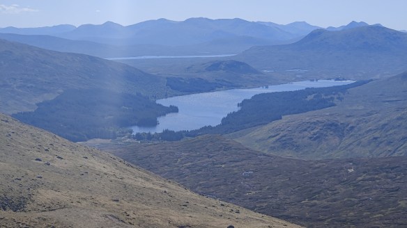
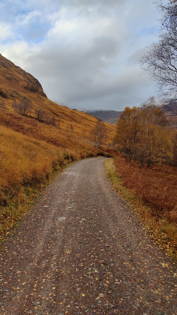
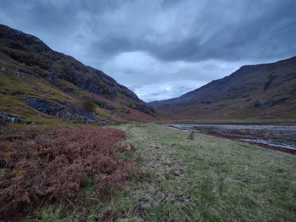
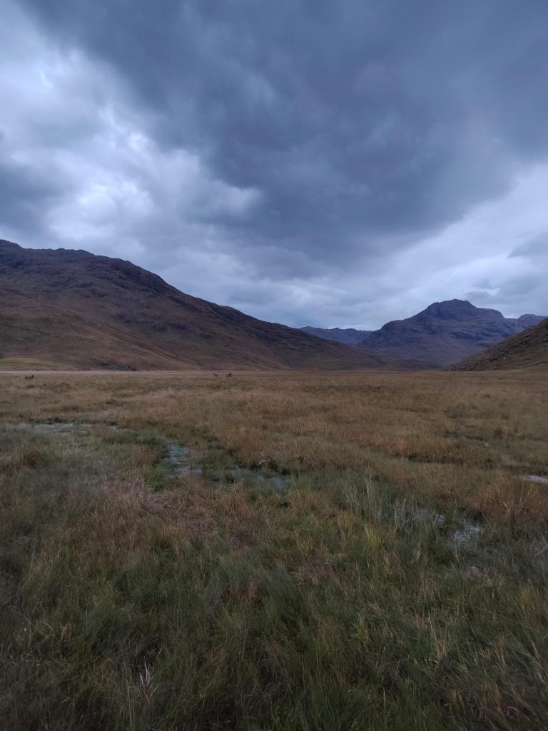
Around 0800 then, onwards through the grey morning, trending ever downhill on a good road across the moor. After an hour or so, Loch Ness and Fort Augustus came into sight, and my heart fell – was it so close? I didn’t  want to arrive there mid-morning. Actually the route has not so much a sting in the tail, as the walk-out is longer than it looks on the ground. On the map it was 12km; it just didn’t look that far. On my way down I passed an estate 4WD rumbling uphill, and a cyclist labouring along. It is a long and seemingly everlasting hill from the Fort Augustus side – rather like climbing Helvellyn from the Thirlmere side.

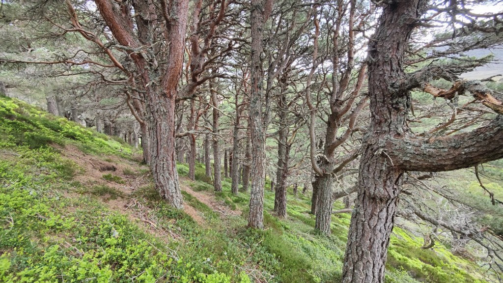
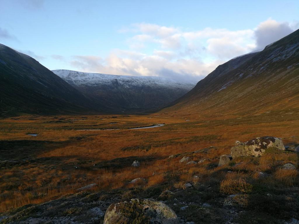
The road came down to another area of confused drumlins and narrow valleys full of trees, all very picturesque and rather reminiscent of the western Peak District. The road splits round a height of 228m at around 371055. General Wade went left; on a whim, I went to the right, along a 4WD road clearly very overgrown and ill-used. Well, not quite on a whim – a study of the map seemed to indicate that there was a way through some rather promising wild woods. I made the right decision! On the mountain, as 1930’s Scots climber W.H Murray noted, it sometimes pays to turn aside commonsense routine.

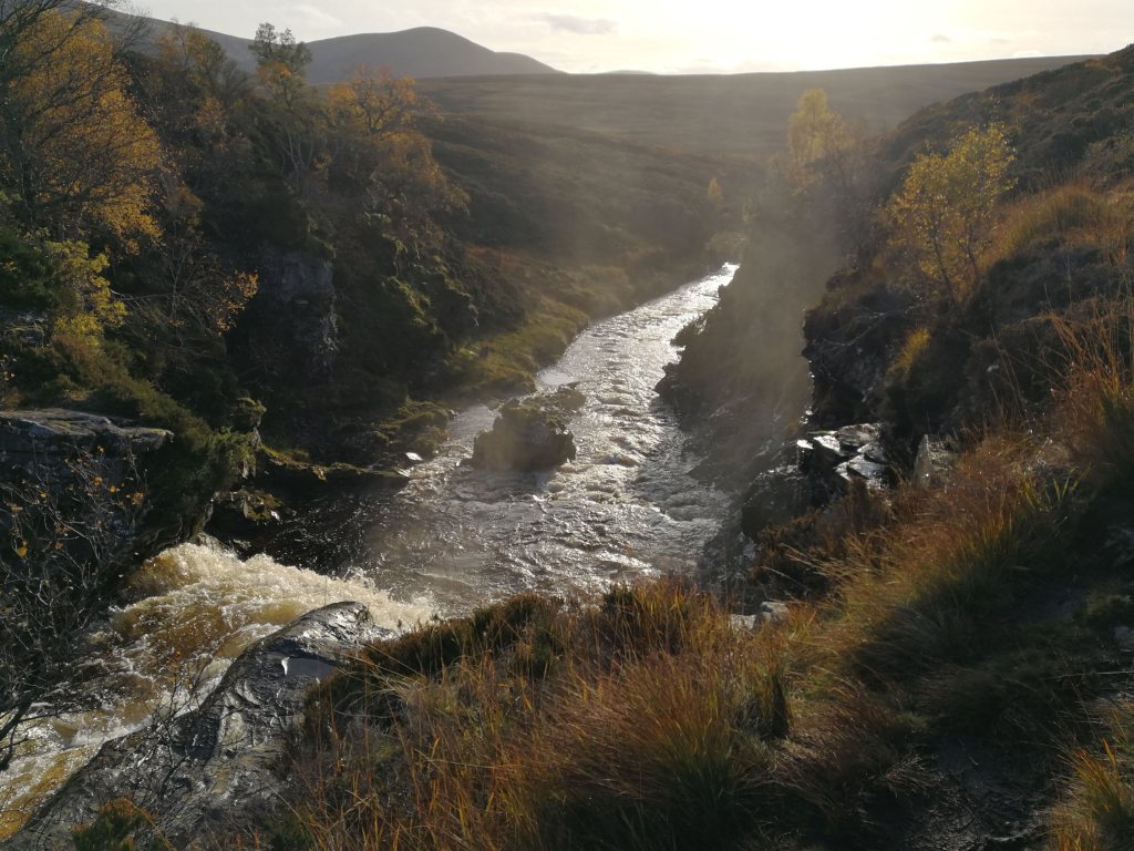
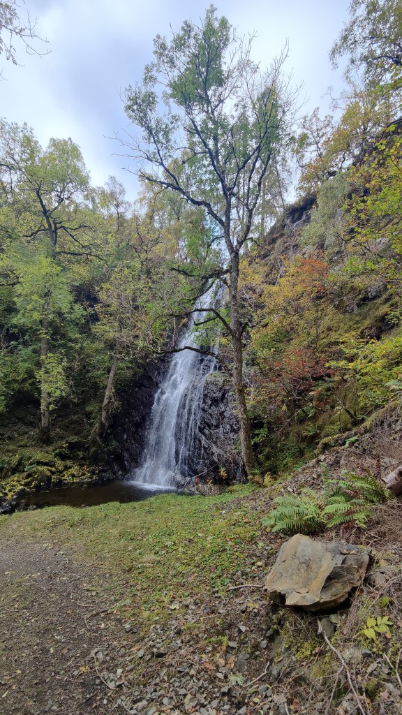
My path led down a long-abandoned un-made road by the side of the stream, down into the most magical valley, a beautiful and silent dell, peopled only by the sound of the rushing waters of the stream. This was the highlight of the trip! I had to carefully ford the stream. I continued, in a little trepidation that should have to turn back at the last. And indeed, the track to Culachy House was gated and very clearly marked “PRIVATE”. But there was another way – a hairpin to the right, down into another deep valley where I found, by chance as it were, the most beautiful waterfall: Culachy Falls.

From the falls a pleasant walk along a path through the woods, across the road and into a graveyard by the river. A little further on, the main road, and my walk was done.

  • Day 1: From Newtonmore to Glen Markie, 25km in 8 hrs 33 mins
  • Day 2: From Glen Markie to Lagan-a-bhainne, 27km in 8 hrs 7 mins
  • Day 3: From Lagan-a-bhainne to Fort Augustus, 12.3km in 3 hrs 28 mins.

I stayed at Morag’s Lodge in Fort Augustus, a former hotel now trading as a hostel. For a modest fee you can share an ensuite room with bunks. For slightly more money but still well below B&B prices, you can buy an entire room to yourself. Morag’s Lodge serve supper and packed lunches and a continental breakfast, and they have a drinks license. There’s a members’ kitchen as well as a proper bar, so it has the best of both worlds. The staff were super friendly and helpful.

The first time I came to Fort Augustus was in May 2012. I’d camped wild the night before further north in the Monadliath. My diary of the time records the following:

Yesterday I drove west from Aberdeen, in wonderful hot mid-20’s weather, enjoying the quiet roads and rolling wooded hills of Deeside. I pressed on over Lecht to Tomintoul through the summer afternoon to Nethy Bridge. Then over Slochd and left down minor roads towards Fort Augustus, at this point looking for somewhere to camp. I turned left again, up a minor side road, going right up over the top into the heart of a dark and wild corner of the Monadliath. The sun was behind me as I drove, and it was glorious. I found a place to camp amidst sufficient dry fallen timber for a jamboree of Scouts to make open fires. I camped in a little copse of pine above the road. It was 9.20pm and full daylight. Sunset at this latitude in late May is 9.45pm. There was sufficient wood from where I sat to make a lovely little fire, on which I prepared sirloin steak (medium) and courgettes and (alas) instant mashed potatoes. A nice S.E Australian Shiraz made it the pleasanter still. I had brought with me 2 litres of water, for there was no running water here – I could not have camped had I not brought water in myself. A couple of times, an estate factor’s landrover drove past and stopped. My fire was making a fair bit of smoke; there was no wind and the smell was unmistakable. They could not see me, and perhaps they cared less, for they did not come looking for me. I went to bed at 11p.m and woke at 5a.m, thence dreaming my way through to 7a.m. Morning was misty, yet dry. No single drop of dew fell, which was remarkable. My breakfast was bacon, mushrooms, tomato, roll and butter, served with fresh black coffee. A breakfast of champions, particularly when served outside.

What struck me most about this camp was the silence. The only noises were the calls of birds, particularly the call of cuckoos, and the sound of sheep. I set off at 8.30a.m in deep mist, back to the Great Glen, and on down to Fort Augustus, where the sun burnt the mist off, leaving a cloudless sky, a glorious summer day. I took coffee and cake at “The Scots Kitchen” in Fort Augustus, and read the paper. Could I ask for more?

An important part of this journey today was the adventure of doing it solely using public transport. I took bus Scottish CityLink bus 919 down Loch Lochy through Spean Bridge and onto Fort William. Once in Fort William I then had to wait a couple of hours for the sleeper train to London, which left on time and arrived more or less on time at Euston at 0800 the next morning. Thence along the Euston Road again and back into St Pancras station, where it was so early, there were no decent coffee shops open yet, and I had to get a coffee from Costa. Onwards home to Derby, and my trip was complete.

From Dalwhinnie to Corrour over Ben Alder and Aonach Beag

At 5pm, to the station at Cromford. I took train through to Derby through the sunny late afternoon. At Derby I adjusted the straps of my new rucksack to what I hoped would be a satisfactory arrangement. I bought a bottle of London Pride from a shop across the road from the station. Through to London in first class, a most pleasant experience for which I paid about £30. I could have picked up the sleeper at Crewe: I have done this before. But then it would have been necessary to wait on Crewe station for nearly two hours til almost midnight. Even on a warm summer evening, that’s not a sensible way to spend time.  I walked the few hundred yards through to Euston station, walking behind the British Library, before joining the Caledonian sleeper a little after 8.30p.m. I ordered a full breakfast for £10- life is too short!  

I slept fitfully, as I generally do on the sleeper train, but I know I did sleep, for I dreamed. I recommend the use of the Caledonian sleeper. If you can stand the narrow bed and cramped conditions, it is in my view, a cost-effective way to travel to Scotland.  I got off at Dalwhinnie, after my full breakfast, into thick, grey morning mist.  The train rumbled off towards Inverness, its red taillight disappearing into the mist. All was quiet. The time was 0655. One man got off ahead of me and walked away ahead of me. 

I started off on the long walk-in, which begins with a detour along the main road as a key level crossing is closed. It is a long and tedious walk-in along a good and reasonably flat unmade road on the west bank of the reservoir, the enormous Loch Ericht, a loch so long that I could see the horizon at the other end of it. From Dalwhinnie station to Ben Alder Lodge, where the route leaves the road, about 12km. I was consciously and deliberately trying to keep my pace down, albeit with only limited success. I’ve seen and experienced in the past, the effects of walking too fast, too soon. But the slowest I could manage along the flat was about 13 minutes per kilometre.  After Ben Alder Lodge the path trends to the right and uphill, through woods onto the open moor. At this point I found myself ahead of the gentleman I’d followed along the lake shore. The path arrows up into the brown hills; it was so very, very dry. Every small stream I crossed was dry; every drain and ditch, just full of dust. I wondered if there was any water at all in these hills. I was glad to arrive at a big stream, which ran clear and fresh, though somewhat depleted. The stream led up to Culra.

I arrived there at around 11a.m, as I’d predicted when planning this trip as a desktop exercise during the winter months. 17km in four hours. At Culra there is Culra Lodge (a wooden hunting lodge, locked down, with a wind turbine), a bothy (closed due to asbestos), and about half a dozen tents pitched. I added my own tent and sat outside for a leisurely lunch. The older man I’d seen earlier, who I’d burned off on the climb up to Culra, arrived and we had a brief chat. His destination, as was mine, was Corrour.  

Looking up towards Culra, with The Lancet in the background

After lunch I pulled together what kit I needed for hillwalking and stuffed it into my now almost empty rucksack. What did I carry? Sunglasses, sunhat, warm jacket, spare long trousers (I was in shorts), first aid kit, food and water, map and compass, walking poles. What did I leave behind? Tent, stove, fuel, sleeping bag and mat, more food, my Kindle and notebook and power banks. After judicious use of suntan lotion, I set off over the brown moor, under a cloudless sky. Up and over the moor, as dry as any I have ever seen, rising into a small glen containing not a high mountain tarn, but a substantial ribbon lake, Loch a Blealaich Bailthe. The atmosphere was magical as the path led round the lake, with the massif of Ben Alder on the far side. I met a young man and woman, mountain cyclists who had cycled over Ben Alder. This hill is so remote that to climb it in a single day trip without the use of a mountain bike is quite tricky, even in summer. Not long after that I stopped for a while for a second lunch and bathe my feet in the loch. To wash your feet in such water as this, on such a day as this, is to wash away tiredness and pain, to sooth away discomfort and ache.  

I continued up to the col – Bealach Breabag – and then on upwards to the right under hot sunshine. It was sleep but perfectly manageable. As I climbed, I encountered a party of five older men coming down, so I knew I was on the right track. Straightforward enough, in this weather, to continue upwards and onwards to the summit of Ben Alder, a most remote mountain.  

Looking down to Loch a Blealaich Bailthe from Ben Alder. In the far distance, Loch Ericht.

Not long after point 1081, I made a grave mistake. Treading north in the afternoon sunshine, I could see the sharp ridge of the Short Leachas ahead of me. There was no descent possible this side of it; the Harvey’s maps (1:40k and 1:25k) I had on me did not reveal a usable descent on the other side of it. Yet, descent there must be – to this day I do not know where. Possibly it goes directly down the Long Leachas ridge. I opted instead to swing to the left and downhill, aiming for the valley of a stream unnamed on the Harvey’s map, along which no cliffs were marked.  There being no signal, my phone would not resolve to the 1:25k OS map, so all I had was the 1:50k which showed this. After the fact, a close reading of even this low scale map does reveal that this is a hanging valley and that therefore there are likely to be cliffs. I should have known better. The sun was bright, the phone screen was hard to see, and I didn’t see what I ought to have seen. To say nothing of the word ”waterfall” which was warning enough! 

This screenshot from the 1:25k map illustrates what a hanging valley looks like on a map
This photo is looking more or less SSE from the path, at the very top of this map image

I descended on the right, keeping in the sunshine, until I could go no further as cliffs impeded further downhill progress. I put away my trail poles as doing more harm than good in a very steep and rocky place. Then I crossed over to the left-hand side, taking the opportunity to drink from the stream, and continued downhill again before my path was blocked by gently sloping slabs as the hanging valley opened onto the main valley. I was almost down and safe – but not quite. With great care and considerable difficulty, I made my way back to the stream, descending all the while, and crossed over again. Most of the time I was descending sat down, but twice on that return to the stream I had to resort to descending face-in, and down-climb. I do not think I could have gone back up: whatever I was doing, at this late stage I was committed to going all the way down. I should have turned back earlier, but I didn’t.  As I scrambled out of the gorge on the right bank again, I saw a huge deer run down to the water and disappear behind a fold of the land. It emerged seconds later barely yards from me, belting down the hillside in a panic of fear. I shudder to think of my fate had it collided with me.  

In all of this descent I was never actually frightened; I was well aware that I could ill-afford to allow vertigo, or fear of getting stuck, to get the upper hand. That said, my pulse was up to 156 and I don’t think that was down to exertion, as I was going downhill. I was lucky with the weather, and I was lucky with the time of year – whatever I did, I had plenty of time. I had food, water and probably 4 hours of useful daylight to play with. From where I’m stood now I got out of that situation not only by luck, fitness and mountaincraft, but by the sheer grace of God.

In due course, therefore, through great care in route selection and discerning choice of foot placement, I made that perilous descent successfully and safely and found myself on the valley floor. There followed a 3-4km tramp through the mid-afternoon sunshine, down the valley to my tent at Culra. 

My supper was taken outside my tent, sat by the stream in the warm sunny evening. I started with that Englishman’s staple, a Nice Hot Cup of Tea. After a break I followed that with fresh tortellini with an admixture of fried chorizo sausage, washed down by some red wine, and followed by hot chocolate. It was a warm night, and very tired, I slept like a top, turning in not long after 2130. 

I was away by 0700 the next morning. I have divided my tent up into three separate dry bags. This makes it easier to pack and easier to keep important parts of it dry. The inner tent, the flysheet, and the groundsheet and pegs are all in separate bags. That was unnecessary this morning after a completely dry strike – there was not a hint of dew. My path led back up the same route I had came down the previous afternoon, but as the Bible and the well-known hymn remind us, “morning by morning new mercies I see” – this morning, with the sun from a different direction, this was a different place, an absolute paradise. A stream wandered down the brown valley, babbling past rowan trees and chuckling to itself as it ran over boulders. Glad I was indeed, to be permitted to be in such a place as this, on such a bright morn. I passed the scene of my adventure the previous afternoon, appearing this morning as grievous shadowed slash on the hillside, and continued upwards to the Bealach Dubh – black pass. I was entirely alone, at this early hour.

Looking up towards The Lancet

Carrying only a litre of water, augmented in my pack-up by several small oranges and a bag of small tomatoes, I set off up the hillside from the Bealach, conscious that I might not see running water again til late afternoon. There was no cloud in the sky; it was barely 0900. Not far up the hillside I did in fact find the very tiniest little streamlet, a mere dribble running clear and cold. Not something one would normally touch, and certainly never in the Lake District with its ubiquitous livestock. I filled my spare water bottle – another litre – added a purifying tab and marked the bottle so I knew which of the two bottles was which. In the end, I never needed it. It was just there in case. My path led up a shoulder of green grass and grey stones, never steep enough to climb with feet and hands, but rocky enough to make trail poles a liability at times. Geal Charn (1132m) was a dun hill, a huge, rounded plateau, a rolling summit of brown grass. As with some of the landscapes on Ben Macdui, it is reminiscent of parts of the Dark Peak – but this is 1100m above sea level. It’s NOT the Dark Peak. From Geal Charn, easy and gentle hillwalking continues, up and down, over Aonach Beag (1116m) and Beinn Eibheinn (1102m). I rather suspect that the ups and downs I found easy, even carrying nearly 20kg, because I’m very fit. There were no clouds, little wind, and no shelter from the sun. In these conditions, a sun hat and sunglasses are PPE, not an optional extra. I met around ten people at various points on this hike, all going in the opposite direction to me. 

View from Aonach Beag towards Beinn Eibheinn
Beinn Eibheinn
Loch Ossian

From Beinn Eibheinn, down to Meall Glas Choire, crossing a rather strange dry gap at 730436. As someone trained in geology I wondered at its formation. It resembled the Chalamain Gap in the Cairngorms, though on a much less grand scale. It is a strange thing to see, at such a high altitude, boulders rounded by some primordial torrent, in what was clearly a dry riverbed. I suspect that at some point at the end of the ice age, the retreat of a glacier has caused some temporary glacial lake to burst its banks, and a torrent like unto Niagara, has carved through this hillside. This kind of thing happens in the Himalaya even today.  

Onwards down the brown grass to a rocky knoll, Creagan na Craibhe, and thence down through troublesome and difficult heather to the stream. This trackless ground was bone-dry and in a normal May would have been difficult, squelchy terrain. The stream was actually a substantial river and was called Uisge Labhair – “the waters spoke” or such. See that Gaelic word “Uisge”? After you try pronouncing it, it will become more familiar. 

And there I stayed, dear reader. I washed my feet in the waters of that noble river, and made my camp nearby, near the place on the map called Lub Mholach. This was the finest camp I have made in many a long year. It was a magical garden spot. I bathed in the river, dried off and had my supper. Red Lentil Dhal, Farinata, Red wine. Though there was no mountain to the west like last night, to provide shelter from the evening sunshine, I was tired enough and retreated to my sleeping bag around 2100, before the sun had even set. I was very cold that night. I had wondered before the trip if I should invest in a lighter weight summer sleeping bag, but my experiences this night, tell me to stick with the three-season down bag and silk liner even in a warm Scottish May 

Next morning I was awake bright and early and out of bed and breakfasting before 0600. A breakfast of champions: porridge (with Grouse and chocolate in it), black coffee with sugar, and fried bread and fried chorizo with melted cheese. My feet, which had been sore in the late afternoon, felt a little better after a night’s rest and some Paracetamol. I packed up and was away before 0700, to hike something like 10km through to Corrour station, arriving there just after 0900.

Loch Ossian
Loch Ossian, looking back up from near Corrour

A delightful hike through the woods along the shores of Loch Ossian. Arriving at Corrour station, in the brown emptiness, under the endless blue sky, I was dismayed to find the cafe shut, but that couldn’t be helped. I had enough food left to make a cup of hot chocolate, and a cheese and egg sandwich, whilst I waited, in company with others, for the train. 

Corrour station house

By train two hours down the line to Arrochar and Tarbet. I had a “credit” for an unused night in the Tarbet Hotel on Loch Lomondside, and I made use of it to stay here tonight. Once checked in, I enjoyed several cups of tea and a long shower, before descending to the bar without boots on, to sit and enjoy a pint and a pub supper after another successful hiking adventure. 

The next day, I took train from Arrochar and Tarbet to Glasgow Queen Street. I walked the few hundred yards to Central Station and took a Pendelino to Preston, then another one to Crewe. I had a “Standard Premium” ticket which was effectively first class without the catering. I thought it was good value at £130 for a four-hour train ride. At Crewe, a seamless change into a smaller and less salubrious train bound for Newark, which encountered technical problems – the first problems on this complex return train journey – which meant that I missed my connection at Derby. Hey-ho – I got home an hour later.  Sat in the train at Blythe Bridge, waiting for the fault to be found, I remember a similar experience as a boy in the early 1970’s on our way back from Blackpool, when a Crewe-Newark train we were in broke down somewhere along there. On that occasion we had to wait a lot longer than an hour. The trains? Cromford to Derby (£8), Derby to London in first class (£32), London to Dalwhinnie in the sleeper (£255), Corrour-Glasgow (£35), Glasgow to Crewe in standard premium, (£133), and Crewe to Cromford (£20). The journey I made could not have been easily accomplished at all without public transport, and I deemed it good value for money. 

Geek stuff – gram counting and costs

My rucksack, an Osprey Aether Pro 75, weighed around 14.5kg without food and water. The Aether Pro 75 is probably the lightest serious expedition rucksack on the market in the UK, weighing a truly astonishing 2.1kg empty. Here’s a table of the weight of some of my kit:

Kit itemRucsac weight
MSR Elixir 2 tent and pegs stored in dry bags, poles2805
Aether Pro 75 rucksack2100
Skyehigh 700 sleeping bag with compression drybag, cotton bag and silk liner in its bag1300
Trangia 27 with matches, striker etc840
Lhotse raincoat580
Spare clothes (socks, underwear, T-shirt)550
First aid kit 460
Trangia fuel (ethanol) with bottle412
Thermarest mat380
Mountaineering trousers365
Notebook with pens260
Goretex overtrousers238
Goretex gaiters 231
Merino wool leggings (winter only)200
Kindle187
2 x Powerbanks 362
Merino wool hat175
plate, cup and spork170
sun hat133
Black Diamond headtorch w/batteries120
Mittens winter only120
Garmin Inreach Mini 2 with karabiner114
Thick gloves 107
Aftermarket rain hood for rucsac104
Ledlenser lantern with cable and battery (winter only)91
Maps85
Sh1t shovel83
Spare drybag70
2 x lightweight (not climbing) karabiners 50
USB-C charging cable50

Backpacking the 4000′ tops of the Cairngorms

What was I thinking of when I (a man 194cm in height) rented a Fiat 500 to make an eight hundred mile round trip drive to the Cairngorms? It is what it is, as they say: the rental cost was modest enough, at least compared to an equivalent train fare to Aviemore. I set off from my home in the English Midlands at 0458, and parked in the scrubland off the road near Whitewell, at about 1350. I stopped three times – at a service area on the M6, at Lesmahagow on the M74 (where there is a very convenient Tesco store literally at the top of the exit ramp) and at briefly at Blair Atholl in the Highlands. Very briefly – there is nothing there!

I was onto the hill before 1430 on a warm and hazy afternoon. I had a heavy carry – almost certainly 20kg; 3 kg of food (for three nights), water, and about 15kg of equipment. I was wearing new boots – Lowa Renegade GTX – and these performed superbly; not so much as a blister over 60km of walking. My route led up into Glen Einich, a route much patronised by cyclists. Several of them came whizzing past including one gentleman on one of those reclining contraptions.

View up Glen Einich

Gradually one leaves Speyside behind and enters a Cairngorm atmosphere. In preparation for this trip I had re-read a favourite of mine, W.H Murray’s excellent “Cairngorm Blizzard“. This is the story of encountering a Cairngorm snowstorm – in May. He writes of Cairn Eilrig as being the “last outpost” of the Cairngorms standing against the pines of the Forest of Rothiemurchus. I passed Cairn Eilrig and eventually could see Loch Einich itself in the distance. The first tactical navigation decision of the trip was upon me. Will I camp down here in Glen Einich, or will I climb into Coire Dhondail, seeking flat ground up there? At this point Coire Dhondail is just a promise on the map, a notch on the distant skyline. At the junction in the path lay two sturdy mountain bikes, completely unlocked.

I opted to climb, and up I went. After a time of climbing in the hot afternoon I was into the flatter ground of the corrie, which was sere and dry grass. There is no tarn – or “lochan” as they say in these parts. The cliffs of the headwall contained a pretty waterfall, as well two or three snowfields. It was not at all clear to me that there was a way up the headwall and onto the plateau. A trip report on https://www.walkhighlands.co.uk/ noted that the path “meanders up the headwall”, but was it passable to a man in his late fifties with less than good balance, carrying 20kg?

The headwall of Choire Dondail

I camped by the babbling brook; there was some light rain and there were occasional violent squalls and gusts of wind, followed by periods of complete silence which weather-wise, worried me more than the wind. I slept well enough – there was a sleep deficit to work off after a busy weekend – and was packed and away before 0700 the next morning.

After my breakfast coffee I set off, not finding the path that had seemed so obvious yesterday, and just went up the hillside trusting to luck. I was not hopeful, but fortunately, I soon found the path. Where one can go, another can follow – with care and a measured tread, and judicious use of trail poles. Soon enough I was up on the plateau. The clouds were down and the wind was howling, ripping along, a strong South-easterly. In these conditions up here on the western side of the Cairngorms one finds oneself climbing through an almost featureless landscape, like the surface of Mars or Venus. The only feature is the fact that the land rises. One must avoid cliffs to the left, and there are cliffs far ahead. It was time for the compass. I bore about 65 degrees – that level of accuracy would suffice. I was concerned that the wind would push me constantly to the left, but my subsequent course reveals that this did not happen. To trust the compass at any time is an act of faith in technology rather than human instinct and inclination, but in these conditions, to do so pays dividends and will save your life. In due course the easterly precipice of Braeriach became apparent in front of me, and I then turned left towards the summit. I admit that I did find the actual summit – a cairn in a featureless wasteland – by resort to the GPS on my mobile phone. The wind was harsh and sometimes bore nasty rain showers: at this point I was in full winter gear including woolen hat, snood and winter gloves, and wondering if it was going to get any colder.

This was the first serious compass work I’ve done in decades. I used a tiny (folding up to fitting in the palm of the hand) Harvey’s 1:25000 map, made of polythene. This was a life-saver. From Braeriach, another bearing, about 30 degrees, through the mist and landscape resembling alien planets, to Cairn Einich, thence broadly south to Carn na Criche and then round the ridge to Angel’s Peak and onto Cairn Toul. As I descended from Angel’s Peak, the weather started to improve, allowing me glimpses of immense cliffs and huge relict snowfields, wild ridges and the distant grey side of the Lairig Ghru.

Angel’s Peak (1258m) and Lochan Uaine

In improving weather I continued down to the col above Coire Odhar. I toyed with the idea of leaving my rucsac there and going light to the summit of the Devil’s Point, but it was so windy that there was a high likelihood that even weighing 18kg and with a fixed hip belt, the rucsac would have rolled away. It was no significant challenge to go from the col up to the summit and back down again.

The view south down the Lairig Ghru from The Devil’s Point

From there, I descended carefully into Coire Odhar – at first the path is steep and nasty, but the slope eases further down. By 4pm I was at Corrour. There were four people at Corrour; two in the bothy, two camping. I had met two people on the hill all day and seen a third person in the distance, so this was a veritable crowd. It was far too early to call it a day – though the people at Corrour clearly did not think so. I had a snack and pushed on, through light rain.

I hiked the broadly level path 5km round to Luibeg bridge, in the grey afternoon, sometimes through rain. Here my mental health failed me for some reason, and I became quite anomalously and deeply depressed. I got to Luibeg bridge grumpy in heavy rain, and with some difficulty managed to fill up my water container before pushing on again up Luibeg burn, looking for somewhere to camp. I just kept putting one step in front of the other. Eventually I found a place to stop not too far from the fords at 012952. I was so close to the burn that I could not hear rain on my tent, and the noise of the rushing water enabled deep and refreshing sleep, something I needed after a long and complex day of over 20km of walking over 11 hours.

I had breakfasted on porridge and coffee, struck camp, was packed and away hiking by seven in the morning. The route went up the ridge of Sron Riach, a geography very similar to The Band in the Lakes. The weather improved, and pretty soon, actual sunshine appeared. The primary difficulty this morning was not going uphill – that was easy enough – it were boulder fields. On a boulder field one might easily fall and bend a trail pole, or even break a leg, or worse.

Sron Riach

Above Sron Riach, one does not follow the edge – as one might automatically – but trends left and slightly uphill, and gently by degrees up to the summit of Ben Macdui. On the way, I was impressed to find a significant burn – the Allt Clach nan Taillear – quite high up, well over 3000′ above sea level, which enabled me to top up my water. I was on the summit before 0930, and considered myself early on the hill.

View from Ben Macdui across the Lairig Ghru to the western summits. Note improving weather

As I arrived, I saw another person arrive – a young Englishman with a full beard, followed shortly afterwards by a European gent carrying a full sized umbrella strapped to his rucsac. I say European deliberately – I’d suspect he was from somewhere like Alsace-Lorraine, for he sounded both German AND French. Up here on the summit there is excellent phone coverage, even to a 4G data signal, from the mast at the ski station on Cairn Gorm.

Braeriach – the classic view – seen from on Ben Macdui

From Ben Macdui to the March Burn is about 1.6km. I must have passed at least thirty people in that distance – every one of them day-trippers carrying little napsacks and some wearing trainers. It’s maybe 10km km, four hours hike, from the car park to the summit. I had not realised that the Glenmore road up to the big car parks below the ski station had made this part of the Cairngorms so accessible. In my experience over 40 years as a hillwalker and mountaineer in England, Wales and Scotland, everyone politely says hello when passing one another on the hill. That memo must not have been read by these rancid tourists. Mind I’ll give them their due – it was a lovely blue sky day and if as a tourist you’re going to do such a route as this, it would need to be on such a day. But it does irk me to see people wearing training shoes and light jackets wandering round a mountain top 1300m above sea level. It has been noted that the summit of Ben Macdui is one of the hardest in the Cairngorms to get down from safely in heavy weather.

At the March Burn at around 1115, a second decision. Will I go down off the hill now, or will I make a side trip to the summit of Cairn Gorm? From Macdui it did not look so far away – an example of how the scale of the landscape can trick the eye. The map did tell a different story – a good 6.5 km from one top to the other by path. I decided to go down, and set off thus, but then moments later, repented of the decision and turned back. I would never again be here in such great conditions as this. There might never be another opportunity. The only place to be in weather like this is on the tops. So I went up – best decision made today.

My round trip to the summit of Cairn Gorm took around two hours from the March Burn, including time for my lunch break on the summit. I deliberately pushed it along the wide, clear path, through brown, dry and sere moorland, oddly reminiscent of parts of the Dark Peak. But this countryside is 1200m above sea level – it is not the Dark Peak.

The path led across two big snowfields, and the scenery was magnificent. The secret and hidden valley containing Loch Avon over on the right – the wild heart of the Cairngorms. The high jewel of Loch Etchachan. The cliffs, the sky, the rolling fields of Scotland away to the north. I’d been here twice before – in 1990 and in 2005 – but both times, in thick fog.

The trip was all brown grassland, stupendous cliffs, white snowfields and blue skies…and tourists. There were several parties of soldiers, all conspicuously tough looking young men all with tattoos and identical rucsacs, not all of whom looked particularly in their element, particularly crossing a large snowfield. T-shirts at 1200m – and here’s me in four layers. There was a harsh wind blowing, and only in direct sunshine was there any real warmth. Along the path I rather belatedly found my sun hat and sunglasses and put them on.

Summit of Cairn Gorm

Back at the March Burn by 1400 hours, I started over the shoulder of the descent track, dropping down through the pleasant afternoon to flat ground before Lurcher’s Crag, and then, very steeply downhill into the Lairig Ghru. One might have difficulty spotting that path and keeping to it in heavy cloud – but right now, barely a cloud in the sky. Downwards over grit and rock and boulder field, to the path that leads through the Chalamain Gap. Tired now, left and back up the Lairig Ghru to where the Chalamain Gap path joins the path down the valley itself. The last bit of that was a stone staircase: I was through here in 2005 and I don’t recall that, but that was 19 years ago.

In the Lairig Ghru, off came my boots and I bathed my feet in the stream. I refilled my water container (upstream of my feet, I would add) and pushed on for the last leg back to the car. It was 1700. It had taken me three hours so far to come downhill from the March Burn. Murray wrote of the “nine mile descent to the Spey” as seeming endless. I figured it was 7km from here to the car – all downhill. On the other side of the valley are structures that look like spoil heaps – but there can be no spoil heaps in this wilderness; they are pure glacial moraines. Down and down – eventually one reaches the edge of the woods, and enters once again the Forest of Rothiemurchus, that bastion of ancient and noble Scots Firs and other aboriginal trees.

Forest of Rothiemurchus

I got to the car just before 1900, increasingly footsore, in the delicate light of evening – or late afternoon really, at this latitude and time of year.

At a crossroads in the forest, I’d stopped for a drink of water – and found that I’d left my water container back where I’d stopped up in the Lairig Ghru! Ah well! It could have been worse. Someone will benefit from it. A quick shift of clothes, swig of warm Coca-Cola deliberately left in the car for that purpose, and I was ready for the off. I drove round to the excellent campsite at Glenmore, where I had a long shower, and then, walking quite slowly, returned to my tent to cook my supper, and so to bed.

Geek details

I walked a little over sixty kilometres in a shade over 21 hours, spending from Monday afternoon to Wednesday evening on the hill. The five 4000′ peaks (Braeriach, Angels Peak, Carn Toul, Devil’s Point and Ben Macdui) took me about 24 hours peak to peak but about 48 hours car to car.

I used an Osprey Aether Pro 70 rucsac, one of the lightest expedition bags on the market at about 1.8kg empty. The fabric is unfortunately not robust enough not to get punctured. Everthing is packed in dry bags anyway; it is otherwise an outstanding bag. I have a Rab Skyehigh 700 three-season down sleeping bag, and an Therma-Rest mat. A counsel of perfection is a silk sleeping bag liner. For a few grams, packing down very small, these offer extra warmth and are useful in summer when a three-season sleeping bag has to remain unzipped. I cooked on a Trangia 27 with non-stick pans – heavy and bulky perhaps but so much easier to use on rough ground than any top-heavy miniature gas stove with separate pans. On the hill I wore a merino wool hat, a merino wool base layer and a mid layer, a fleece, walking trousers, and Goretex raincoat, overtrousers and gloves as necessary. Proving unnecessary but had to be carried nonetheless, were spare walking trousers, Goretex gaiters, a torch, and heavy winter mittens. I used Harvey’s excellent polythene Cairngorms 1:40000 and 1:25000 maps. I took two Li-Ion power packs weighing in total about 800g – unavoidable. My mobile remained in flight mode except when needed, and was actually switched off at night. I tracked my hike with a Garmin Vivoactive 4, which will not even last a full day tracking activities without a battery top-up.

I rented a Fiat 500 from Europcar, for a week, at a cost of around £286 including additional (as in beyond the statutory minimum) insurance. I would not have rented such a small car had I thought more deeply when I booked it. The kindest thing I can say about it, is that it was adequate. I burnt fuel worth £101 to drive around 800 miles. Excluding the cost of the various brown food bought to sustain me on the journey, the journey cost around £390 – approximately 50p/mile. As I’ve argued elsewhere, ground-based travel that costs substantially less than 50p/mile, is almost certainly being subsidised, either by the tax-payer, by other passengers, or by the company providing the transport. As an alternative option, the return train fare from Derby to Aviemore (in standard class) is about £220. One has then to add the cost of buses and taxis to get on and off the hill, and take into account the fact that one cannot take additional shoes or clothing without lugging them around on the hill. I also took the opportunity of visiting friends at Ballater whilst I was in Scotland, something that would have been very much more complex, if not impossible within my allowed time frame, had I took the train.

On foot from Bridge of Orchy to Fort William

I took train to Crewe, arriving in good time for the sleeper service to Scotland. The train slipped into the platform almost in silence, as if to not disturb the sleeping customers. I boarded, and off we went. In the morning the train stopped for a while at Tarbet on Loch Lomond-side. I could hear the rain drumming on the roof of the carriage – but that was at least forecast. I was allowed by the male provodnik (Russian for “sleeping car attendant”) into the “Club Car” for my breakfast, and told somewhat loftily to sit “over there” clearly away from the very few first class customers. Feeling less than welcome, I had my sausage bap and cup of tea, and left.

At Bridge of Orchy I got off, and under the shelter of the station canopy, prepared for hiking. It was raining. The buildings of the station have been converted into a low-cost hostel, although I saw on social media that this hostel has a poor reputation as being somewhat spartan. The West Highland Way, or proximity to it, is an opportunity to sell excellent services to travelers, or perhaps, in some cases, a magnet to less scrupulous property owners hoping to make a fast buck from accommodation. The railway station itself is uncrewed – as was the hostel, at this time of year.

I left, in the dripping rain, and almost immediately passed the only southbound hiker I saw in two full days on the hill. It was 9.a.m. The initial part of the route lies over the summit of Mam Carriagh and is marked on the OS map as an “Old military road”. It is one of General Wade’s roads from the early eighteenth century, from the years of the Jacobite rebellions. As I walked, the rain rose to a crescendo, and I made full use of my new Mountain Equipment “Lhotse” jacket, which I bought heavily discounted from Cotswold. It is has a great hood, but as a tall man I could do with a waterproof least six inches longer in the body – a coat in fact, not a jacket. Why are modern mountaineering waterproofs all jackets?

I came down to the Inveroran Hotel, all shuttered up now for the winter, in grey and spitting rain. Onwards onto what was referred to on a sign as the “Old Drovers Road” to Glencoe, which was ostensibly the main road before 1933 when the current road was opened. Of the current road, arrow-straight across Rannoch Moor and with sweeping curves down through Glencoe, the Scots mountaineer W.H Murray once said (a propos of complaints that it spoilt the landscape) that the new Glencoe road could “no more spoil the landscape than the facade of Chartres Cathedral could be damaged with a pen-knife”. Murray was quite right – and he was an early environmentalist.

The drovers road across Rannoch Moor

There is no evidence that this road was ever covered in tarmac – it is stones and cobbles now. Ninety years is a long time; the tarmac could be long gone, but I somehow doubt it ever was a tarmac road. I found the road very hard on my feet, but that may be because my current boots are approaching the end of the natural life and may in consequence be a little thin in the sole. But it is a good road, passable by car even today (were it allowed – of course it is not), albeit at not much faster than 10mph. It rises gently from Victoria Bridge at 174m to a summit of 353m over 7km, before falling again down to the access to the “Glencoe Mountain Resort”.

Is there a sport less sustainable than skiing? I am a mountaineer. I seek to cross mountains for pleasure, doing so on foot, doing so safely, and leaving no trace other than footprints. There are few things I find much more depressing than a ski resort in off-season. (Maybe a British seaside town in February…) A ski resort needs good roads, ski lifts, hotels and shops, bars and restaurants, accommodation for staff. It needs street lighting, drainage and all the other municipal services we take for granted. All these things are good things of themselves. But out here in the beautiful autumnal brown of the Blackmount in November, I find it all rather jarring. Even as I stood by the roadside thinking this, a 32 tonne truck rumbled past carrying a snow-mobile and ski-lift pods. I finish where I started: can there be a sport less sustainable than skiing?

Crossing the A82 as quickly as possible, but with great care, I continued. From here to the Kingshouse the way leads along what is clearly a former tarmac road. The Kingshouse, once merely a hotel, is now a small community. One day, it seems to me, it may be an actual village called “Kingshouse” – there are diverse lodgings and houses, and a community centre, as well as the eponymous and famous hotel with its extensive car park. It even had a roundabout. In the car park I had to detour round tourists taking photographs of a red deer which had wandered in. The weather was darkening.

A hundred yards past the hotel, once again in open country, I decided to stop for a snack. My mountaincraft is sharper and better than I know; it works at a subconscious level. I had barely finished my chocolate and so forth, when a squall of rain and hail descended. I was hard put to get my hat, gloves and scarf sorted and my coat zipped up before the onslaught. How had I known that the squall was so imminent? How did I know to take this last opportunity for a snack for an hour or more? It was surely neither luck nor coincidence.

The next stretch of the road was again an “old military road” more or less parallel to the A82, finishing at Altnafeadh. The weather was dreadful; grey cloud and squall, brash wind and rain. I would have taken more pictures of the magnificent towers of Stob Dearg (“Buchaille Etive Mor”) on my left – perhaps the most recognized mountain in the UK. But others have photographed that graceful hill more effectively than I, and I was loth to take off my gloves in this rain.

Stob Dearg (“Buchaille Etive Mor”)

At Altnafeadh it was 3pm. The traffic rushed past; the clouds lowered. Time-wise I was on target. I had thought I might camp here, having at very best maybe ninety minutes of daylight remaining, and not wishing to be caught in the hills above the Devils Staircase. But there was no suitable location, and the rain came down. I had a little snack and a fat little robin came and sat near me; I fed it with some of my wife’s Rice Krispy cake. Onwards: in heavy rain and hail I started up the Devils Staircase. A struggle if you’re not fit, that ascent, but I pushed very hard and fast uphill, to the point of starting to overheat. Time was of the essence now. I had to find a flat and sheltered place in the hills to pitch my tent, and I had to do so pretty much within the hour.

I thought, looking at the wind direction (this is mountaincraft again) that the weather would be better on the far side of the hill up which the Devils Staircase goes back and forth. I was right to think that; so it proved. On the Rannoch/Glencoe side, grey rain, clag and wind, hail and storm. On the far side, calmer, even to some blue sky. I pushed on over as late afternoon became evening and dusk, looking for a camp ground. I had limited daylight and my salutory experience in the Cairngorms two years ago was fresh in my mind. I found a flat place right next to the trail, right next to a stream. Not a place I’d choose in summer. The place was more or less where I had predicted from theory beforehand that I ought to camp, in order to make this passage from Bridge of Orchy a two-day rather than three-day hike. It was the stream of Alt a’ Choire odhair bhig.

My tent went up easily enough, pitched outer first as rain looked imminent. In fact I had not long been pitched when there was a tremendous hailstorm turning the world white. I found it hard to get warm, but once I’d eaten and gotten into bed, I warmed up in due course and slept passably well, being in bed for nearly 12 hours.

I awoke respectably late, but still before dawn. Surprisingly so given that I had been in bed for almost 12 hours. I went through the drill of having breakfast (porridge with an admixture of chocolate, sugar and sultanas and a little malt whiskey) and striking camp. The practice of solo backpacking and wild camping, particularly in autumn or winter conditions, is the practice of detail, the practice of method, the practice of doing things right, in the right order. In other words, it is the practice of mountaincraft. This is one of the reasons why I put myself through it. It is no ordeal; it is a pleasure and a privilege. It is a pleasure and a privilege to be alone in the wild. I can put myself, in an uncontrived way, in a place where doing things right, in the right order, is the difference between, on the one hand, an enjoyable and relaxing experience, and on the other, a dreadful or even life-threatening experience.

I was on the hill, full of breakfast, by 8a.m. I had a long day ahead of me of 32km, but I knew I could make Fort William, if not by nightfall (about 5pm) certainly not much later. I started out in Gore-tex over-trousers but today’s weather was much more forgiving and they soon came off on the descent to Kinlochleven. Early on, I had problems with very cold fingers, as my gloves were wet from the previous day. I had to use my big mittens, which were still dry. One action from this trip is that I need to think carefully about carrying multiple pairs of gloves (as one carries multiple pairs of socks), or, look into waterproof gloves. The light and the views this morning were lovely.

Coming down into Kinlochleven one sees six tremendous pipes marching across the landscape, bearing water from the faraway dam on the Blackwater Reservoir. At the bottom of the hill by the river, an enormous and striking mill, Edwardian architecture with some Edwardian technology inside and out, as the rushing water from the great pipes feed the hydroelectric plant inside. Kinlochleven at 9a.m was quiet and cold, only dog walkers were around. I’d been aware that I could have resupplied here to save weight, but it turned out that I needed nothing, and I walked on out of town without stopping. Kinlochleven is rather sleepy and forgotten since the opening of the Ballachulish Bridge in 1975. Today it seems little more than the start of the final stage of the West Highland Way. That said, its location is stupendously beautiful, central to a wide range of wild country and high mountains. It reminded me, however – particularly in cloud-streaked autumn at that time of day, of the town in the Pacific Northwest in Sylvester Stallone’s film “First Blood”.

I climbed up out of town through pleasant and fragrant managed pine woods, emerging into a higher, colder valley. “Footpath to Fort William via the Lairig” the sign had said. The path runs true up the right hand side of the valley, reaching a bealach at which there is a substantial ruined house. From here, one cannot see where the route goes, but it curves round to the right and to the north. I passed a young woman out from Kinlochleven; she said she was just doing this last stage. Only the second person I had seen hiking for two days.

The ruins at Lairig Mor

The path continues northward, a little open on the left, with higher mountains on the right. Such trees as there were in the area were not entirely consistent with their representation on the map – this is a working plantation. I had been saying to myself, “Ben Nevis dominates Fort William, but I cannot see it yet. When will I see it, and know that I am getting closer to my destination?” The path kinks round to the right, trending more north-westerly, and finally, in the afternoon, I found myself in a place where I knew that just beyond, lay Glen Nevis. At the head of this valley was a confusion of hillside, rather strange looking. Some odd geological effects were at work here. In the heart of the confusion, lies the ancient fort “Dun Deadail”.

Nevis seen from the trail not far from the fort “Dun Deadail”

From Dun Deadail, the way lies along forest road all the way down to tarmac in Glen Nevis. In the deepening cold of late afternoon (that is, 3pm at this latitude and time of year – it’s great to come to Fort William in May when “late afternoon”, from the perspective of the sunshine, is 8.30p.m!!) I trod the forest road down, and then tramped the final tough tarmac mile or so into Fort William.

Glen Nevis

In Fort William I was met by a friend of mine who kindly arranged for me to stay at the excellent Fassfern guest house on the shores of Loch Linnhe. We had a couple of pints and some pizza at the Black Isle pizza bar in town, but to be honest, after my trek I was shattered, and was glad to be in bed by 9.30pm.

A ten-hour train journey

This first leg of the immense train journey back to the English midlands leads through a brown, grey and relict green autumn landscape, towards Spean Bridge. In the distance, cloud-draped mountains have winter’s first coat of snow. Behind me in the tiny two-carriage train, are five mums with at least that many toddlers, dogs, bicycles and pushchairs, all off on a short winter’s day’s outing to Corrour. The toddlers are all of a gurgle; at my feet, one of the dogs has settled down to hide from the youngsters. The train wends its way along a gorge; the frothing river is the colour of Guinness being poured. You can hear the engines straining as the train climbs the grade up onto the moor. I could be on worse train journeys and I probably will be later today.

Crianlarich: nearly two hours out from Fort William. It would take an hour to drive here from Fort William, though to be fair to the train, it does take that huge detour up to Spean Bridge. As someone with a passing interest in railways it is interesting to note that some of these Highland stations still retain a substantial yard with sidings. Generally these are used, on this remote single-track railway, to store modern permanent way repair equipment. In England, many of these yards have long since been converted into car parks, particularly in the metro area where commuters dominate the market. This little train dates from the late 1980’s, and the technology in it is much older than that. Hearing the sound of the antique brakes, though I’m sure they are perfectly good brakes, makes me feel about 12, so much does the sound remind me of 1970’s trains.

At Queen Street station in Glasgow, a delightful Victorian arched train shed, I join a brand-new electric train to Edinburgh. The Scots at least, have a constructive view on railway electrification: that is, do as much as possible, as soon as possible. I have a sneaking suspicion, however, that English tax-payers will be picking up the tab for it, even if the Westminster government and the Department for Transport feels it can’t afford the same for England. Who needs joined up thinking? I read that these new and shiny 21st century trains are actually owned by a Japanese bank.(https://en.wikipedia.org/wiki/British_Rail_Class_385). Another piece of evidence of the chronic short-termism of the people who manage and finance our railways.

Arriving at Waverley station in Edinburgh, I had to make a decision quickly. I had a seat booked on the 1707 X-Country service straight through to Derby. It was cancelled. The time was 1636. I might travel at 1710 down the east coast route towards Kings X, and change at Newark, and then across to Derby. Or, I might travel at 1652 down the west coast towards Euston, and change at Crewe, and then across to Derby. Which is better? Six of one and a half dozen of the other…or is it? this is advanced travel knowledge. I opted for the latter and joined an Avanti West Coast Pendolino bound for Euston. That was a good decision. As I’d opted for a very reasonably priced first class ticket, I got a nice panini and at least two Gins and Tonic, thrown in. That enlivened my journey to my home, which took until nearly 10.30p.m. That said, I left Edinburgh at 5pm and arrived at Derby about 9.30p.m, and that involving a change of trains. You’ll nae be driving from Edinburgh to Derby at that time of day, or at any time of day in fact, in four and a half hours.

Loch Nevis again

28/5/23: Once again I come aboard this vessel as she prepares to cross to Rum. Today is a Sunday, the first time I ever made this crossing on a Sunday. I just bought a sausage bap and a Flat White from a most friendly pair of people behind the counter. I was struck by the friendliness of people here on the West coast of Scotland. The lady at the campsite “Tigh na mara” likewise was quite naturally open and friendly – even more so once I told her I was going to see my sister Fliss Fraser. After nearly twenty years living near London and commuting into the heart of London every day, it is remarkable to be amongst people who are naturally friendly. A similar paradigm prevails in our new home on the sourthern edge of the Peak District – even the teenage boys on their way home from school, nod at you politely and say hello!

I set off on Saturday morning from Chesterfield, in a rented car. I used the “eastern” route up the country, that is, going north up the A1 and west across the A66. I shan’t do that again. The M6 will be almost invariably quicker. At one point on the A66 I had to come off and detour across country to get past a queue following a tractor. One great thing about that road though, is the western descent to Penrith, where one might gaze on the distant but distinctive shape of Blencathra on the northern edge of the Lake District. My second leg, after a brief lunch at some farm shop in the Pennines, was very swiftly up the A74(M) to Lesmahagow, where there is an exit with a Tesco, including a petrol station, right at the top of the ramp.

From Lesmahagow, north over the Erskine bridge and onward through Dumbarton, where I have stopped so many times back in the days when there was such a thing as Little Chef. Once north of Dumbarton motoring actually becomes a pleasure, particularly at this time of day, though there were still plenty of motorhomes and pootlers to get past. I stopped for a brief rest at the Glen Etive crossroads under another distinctively shaped mountain, Buchaille Etive Mor, before plunging down through Glencoe and onwards to Fort William. I camped near Arisaig, at a little place called Tigh na Mara, right at the end of the road, beyond Back of Keppoch. And right good it was too – a lovely family campsite with excellent, even superb facilities.

In the morning early, into Mallaig to park up, and thence across to Rum. I was minded to look back and see when I have visited my sister at Ivy Cottage on Rum. It is instructive.

In 2002 I came here before the jetty was built – I remember trans-shipping from Loch Nevis into a small boat in order to get ashore. A different world then!

In 2004 I came here with our three kids by car from the midlands (that was the year it poured with rain at Camusdarach, and they all sat in the car, as they ought, whilst I struck our tent in the heavy downpour. I can still feel the rain on my back.) That was also the year we played Lord of the Rings Top Trumps, sat in a car park at Crianlarich, resting between driving legs on the way up. Family memories!

In 2005 we came back: I bought the kids by train from London. We travelled in first class for a reasonable fee. My first experience of a Pendolino: I remember an American lady saying “I wonder what Coach is like, if this is First Class?” Indeed.

In 2008 all of us visited for the wedding of my sister. Some of us came by sleeper train, some of us, by car. That was the only time I ever got stopped for speeding…it’s a fair cop, guv. Everyone was nice about it. It’s not as it it was actual dangerous driving – not on that road, at that time of day, in those dry, well-lit conditions – as the policeman himself noted at the time.

Then I didn’t visit Rum again until the modern era: I was here in 2016, 2018, 2019 and now this visit, my first visit post-lockdown. It is an extraordinarily difficult place to reach. In the interim period, between 2008 and 2016, I was very busy every summer with Scout camps.

Here on Rum the May weather is glorious. If the wind drops, the midges bite a little but not quite enough to drive a person indoors. At least two different types of cuckoos are calling, as they do in late Spring. Beyond that, the silence here is palpable, so much so that one can hear the engine noise of the ferry across the bay.

Much discussion of art and craft, of gardening and cooking, of writing and fitness – running and wild swimming. One of the books recommended by my sister is “The Artists Way” by Julia Cameron. She speaks of “morning pages”, writing three pages every morning, just to get the creative juices flowing. I wonder about the security and privacy of my notes – there is none. Anyone might pick them up and read them. I have written stuff that whilst it might not actually get me arrested, would possibly increase the likelihood of a period spent indoors at His Majesty’s pleasure, under the Mental Health Act. Bob Dylan sings “if my thought-dreams/could be seen/they’d probably put my head/in a guillotine” – that’s me.

The Rum Cuillin

In glorious sunshine I ran up into Coire Dubh, passing two parties on the way up. I was able to make use of water from streams right up onto the shoulder of Hallival, which was good news on such a hot and dry day. Thence, up onto Hallival. This wasn’t so easy, though the route was pleasant and dry. From Hallival, down over rocks and boulders and steep, dry dirt, to the col.

Eigg seen from Hallival

Askeval looks very serious and technical, starting as it does with a very steep and narrow grassy ridge. There is a reasonable path winding it’s way up the grassy eastern face, so one is never in danger of losing one’s way. As an older man I find vertigo creeps up on me: I would have raced along this ridge thirty years ago. Today I can see the ground far below in the corner of my eye. My balance and head for heights are not what they were when I was younger. Also, my perception of risk, particularly alone on the mountain, is changed somewhat.

Askeval

From Askeval, down into the Atlantic Corrie, through some tremendous, lonely rock scenery. Few people come here. There is an immense walk out to the Harris road, across trackless moor and knee-deep grass, which in claggy or wet conditions would be a real struggle. Physical fitness rendered the walk out merely tiresome, and I made it the Harris road by 4pm or so. I was even able to run out down the road back to the village.

Last night we saw a Basking Shark in the loch, and at least a dozen deer stood on the foreshore at low tide. The deer, alas, are ubiquitous and everywhere – even in my sister’s back garden. You can’t grow anything in a garden here, except you put up a tall and expensive deer fence.

As so often in the past, I left on a glorious sunny afternoon to return to the mainland. I drove down to the Claichaig and camped nearby, and then set off the next morning very early for the 380 mile drive back to Chesterfield. And this is what I saw on the way:

A diesel gala day at the Speyside Railway – November 2019

I was out touring in Scotland on my own, having a short break to myself, recharging the moral and emotional batteries. After leaving the Atholl Arms Hotel at Blair Atholl (see More Scottish travels) I made two short detours along single track roads through grey and rainswept countryside deep in fall colours, and after some indecision about which route to take, found myself at the Sugar Bowl Café in Kingussie, a pleasant room painted grey and orange, the steamed-up windows indicative of a warm welcome within, shelter from the driving cold rain of November.

grey and rainswept countryside deep in fall colours

I sat over coffee and cake, looking through some purchases from a nearby second-hand bookshop. I had “The sending” by Geoffrey Household, “Raw Spirit”, the de facto autobiography of Iain Banks (but on the surface, a book about malt whiskey), and “The January Man”, an account of a year of walking Britain, by a guy called Christopher Sommerville.

I made an entry in my diary, and put my pen away. I happened to check my phone and I saw that the nearby Strathspey Railway were having a Diesel Gala Day! I left the café on the instant, in a heavy downpour, and returned to the car. I drove to Aviemore and parked up at the heritage railway car park, again in heavy winter rain. It was 12.50.

In the cold and wet station I learned that the next train was at 13.15. On the platform I got talking to Duncan, a professional photographer who took a few pictures of me enjoying myself. https://www.duncansphotography.co.uk/

From here on in the reader has to put up with nerdish trainspotter details about locomotives and carriages (for which – while I explain it – I make no apology.)

Mark I first class compartment

In due course an old English Electric “08” shunter brought in the train, and a Brush type 2 locomotive was attached to the front. I sat resplendent and alone in a very well-appointed Mk 1 FK (First Class Compartment coach). It had an absolutely lovely atmosphere. For me it is the ambience of the old Mk I’s; the woodwork, the lamps, the curved sheet metal ceilings. The sound of the doors slamming that make me feel about 10 years old, going on holiday to Skegness or Blackpool. Notwithstanding the atmosphere, I “bailed”, as the train-spotters are fond of saying, at Boat of Garten, hurriedly crossed the footbridge, and joined the up train back to Aviemore, which was hauled by a Birmingham Railway Carriage and Wagon (BRCW) Type 3. A “Class 27” since the 1970s. This was mostly the newer (but still vintage) Mk II stock, still atmospheric, still nostalgic, but not quite the same as the old Mk I compartments.

BRCW Type 3 locomotive

When the railways were nationalised, British Railways found itself in charge of an absolute plethora of styles and designs of coaches, inherited from the four large companies that existed before. Some form of standardisation was required: from this, in the late 1950’s, came the British Railways Mk I coach.

This was the experience most people would have on a railway journey in the UK from the early 1960’s until the late 1970’s and indeed later, although newer designs were brought out subsequently. The Mark II arrived in the late 1960’s; the first air conditoned Mark II not long after that, and then the Mark III in the early 1970’s.

These are still around – they are the carriages seen in the old “HSTs” which can still be seen in Scotland and down in Cornwall. The privatised railway of today is up to Mk V which are the coaches used for the most modern trains like the Caledonian Sleeper. The final Mk I coaches were the old “slam doors” used in the south of England, and these were withdrawn as late as 2005.

Mark II first class compartment

I ordered some tea, crisps and a sandwich. The sandwich was freshly made! What a remarkable thing. I chatted sociably with the guy selling the food. At Aviemore, off the train and back on, and then all the way down to Broomhill at the other end of the line.

The sound made by these Sulzer engines in the Brush type 2 and the BRCW type 3, particularly when they are working hard, is really quite something; it is a magical music to my ears. There are, for me, few sounds that have quite the same effect as does the sound of a vintage diesel locomotive – or perhaps in particular, these slow-beating Sulzer engines.

One might have a hopefully pleasant Pavlovian reaction to many sounds – for example, the sound of a drinks can being opened, or that sound described by Alistair Cooke as the “most civilised sound in existence”, that is, the sound of ice cracking as spirits are poured over it. But for me, it is the sound of diesel locomotives, reminding me as they do, of going on holiday when I was a small boy.

From Broomhill back to Boat of Garten, where I changed again from one train into the other. As the afternoon went on, the weather and the light improved, though heavy showers persisted. I took loads of pictures.

From Boat of Garten back to Broomhill, then all the way back to Aviemore, arriving in the dusk after as remarkably moving and relaxing afternoon as I’ve had in recent years. And this on top of everything else this weekend bas brought. I paid £23 for a “Rover ticket” which enabled me to make something like six separate journeys up and down. I think I got my moneys’ worth.

A trip to Knoydart – extreme backpacking in October

A trip to Knoydart – extreme backpacking in October

My trip this October, in the planning these last three months, was to walk from the railway at Glenfinnan, through to Inverie on the Knoydart peninsula. Inverie is one of the most remote places in mainland Britain. The walk itself I understand is part of the so-called “Cape Wrath Trail” though there was nary a sign at any point to indicate that.

I took the 48km walk in three more or less equal stages of about 16km each. From Glenfinnan to Strathan, Strathan to Sourlies, and from Sourlies to Inverie. As I was hiking alone, completely out of phone range, I don’t think I’m exaggerating to call it “extreme” backpacking. Conditions underfoot were absolutely dreadful, wet and deep mud and peat throughout. Across that ground, I was walking at barely 2km per hour averaged over the whole day. I thought I’d meet few people if anyone at all, mid-week in October, but eight other people were on the hill travelling more or less the same route at the same time. We met several times, finishing with drinks in the Old Forge in Inverie.

As in the past, my journey north on the Caledonian Sleeper began with a pint in the Doric Arch at Euston station. Virtually deserted on a Monday night, this railway-themed public house has a giant scale model of “Evening Star”, British Rail’s last steam locomotive, strategically placed behind the bar.

It was really rather pleasant to sit in my berth in the morning, watching the West Highland landscape scroll past the window. Breakfast came as the train rounded the famous Horseshoe Curve near Bridge of Orchy. At Fort William there was ground mist. My eye was caught by a Stanier Black Five stood waiting in the mist for the off with the “Jacobite Express” charter train to Mallaig.

After shopping for some minor groceries in Fort William, I took train a little after noon to Glenfinnan. The mist had burnt off; the skies were clear. The train was absolutely rammed full of tourists, and the officials of the railway company, in consequence perhaps, were a little above-averagely irascible. Passengers must not leave bags here…bicycles must be stored front wheel uppermost…

In the most beautiful clear weather, I hiked up through the heather and trees towards the viaduct. It is concrete: anywhere else but in this stunning location it would be ignored as an industrial monstrosity. But here, certainly since Harry Potter, people travel hundreds of miles to visit Glenfinnan viaduct.

The way ahead lay up a tarmac road through Glenfinnan. As a 10k runner I have learnt much about pacing myself this last year – but not enough. Though I consciously tried to keep the pace down, I still went too fast along the tarmac and in only a few kilometres the hard impacts did more damage to my left heel than in the whole of the next three days, causing a small blister. I continued past the bothy at Corryhully, taking a late lunch, and continuing up to the top, the Bealach a Chaorainn. Here there was a rather surreal gate with no fence on either side of it. Onwards, trending north-east away from the setting sun, down into a wide glacial valley, the long and straight Gleann Chaorainn. As the afternoon wore on, the light grew more delicate.

The ground underfoot became boggier and more complex, and I was starting to tire. As the valley came out into the bigger Glen Pean, I fell over in deep mud and somehow managed to buckle the bottom third of one of my trail poles. Ratty, I crossed the bridge over the Pean and approached a band of forest. Here I met the first of the eight people who were crossing to Inverie at the same time as me, an Englishwoman called Suze and her partner Andy, a Scotsman. After a brief chat I left them in peace and sought somewhere to pitch my tent. But the ground was tussocks and hummocks, dreadful, pathless wet ground wholly inappropriate for camping. In the middle distance I spied some different green, and thought, that might a better campground. It did – but it was on an island in the river. I crossed to the island with only minor difficulties (the boulders in the stream bed were a bit slimy). I deemed the risk of flooding on this particular night, to be negligible, although there was clear evidence that the island could and would flood when the river rose in spate.

Next day, the tent was wet inside and out with dew and condensation. In packing, I found that I had inadvertently brought onto the hill, over half a kilo of spare cheap tent pegs which had been stored right at the bottom of my rucksack. Rather too much weight to casually carry around – I had to abandon them. I crossed the river again, noting that the river had fallen during the night, and set off into the forest. The route lay along a track that clearly predated the trees (an industrial plantation) by decades if not generations. Round onto a forestry road and onwards; beyond the woods, the sky was clear and blue. A choice presented itself: I could hike up Glen Dessarry in the woods, or in the sunshine. On such a beautiful morning, it had to be the sunshine, at the expense of a short detour.

There is a reasonable unmade road up Glen Dessarry, up which it was my task to toil. I took an early lunch – or maybe it was second breakfast. I am become a creature of Hobbit on the hill: bread and butter, cheese, tomato, Chorizo sausage, chocolate, date/nut/seed trail mix, perhaps an orange. At Upper Glendessarry the path leaves the unmade road and kinks to the right – “Inverie, 17miles” a sign says. Wet and very muddy, the path continues, keeping another industrial plantation on the left. I reached the top edge of these upper woods and found a convenient flat stone on which to have another snack. A mile or so away below I spied two hikers, presumably the Scotsman and Englishwoman. They saw me clearly against the sky, and waved, but I missed that. They must have taken the route through the woods. As I lunched, a single Typhoon fighter roared past in the distance.

Lower Glen Dessarry
Lower Glen Dessarry
The lodge at Upper Glendessarry and the sign for Inverie
Looking back down the glen from the upper woods

The path continues upwards, always wet, muddy and boggy, over Bealach an Lagain Duibh, which to my unschooled eye looks something like “Black Lake Pass”. One arrives in due course at two linked lochans, dark and forbidding in the lost, high hills. That said, the sun was out and though the water was black, the mood was not too bad. Lochan a’ Mhaim, it is called. On the bank of the second of these, a small boat was stashed, having clearly been laboriously carried up from Loch Nevis.

Lochan a’ Mhaim

On the way down to Sourlies from this lochan, there was at least one significant ford over the Finiskaig river. One has to take care with fords, hiking alone. The trail poles are a great help in safely crossing a river. It was a lovely walk down through variable terrain, but always muddy and wet underfoot. At times the river meandered as a “misfit stream” through the valley, then it dropped down through a gorge to the valley floor proper at the head of Loch Nevis. After the initial significant ford, the path kept to the right all the way, sometimes high on the hillside above the river, other times, lower. I passed three people, the first of whom I spoke with briefly. In a strong Slav accent, he told me he was making for the roadhead at Strathan, and that his friends were some hours behind him. An hour or more later I passed his companions. A lady with a Husky and an older, less fit looking man, labouring slowly up the hill with stertorous breath and a Cross of St Andrew on the back of his rucksack. They had started from Sourlies – and late indeed was the hour for them to be passing me not even close to half-way to Strathan.

The Finiskaig River as a meandering “misfit stream”
The view down towards Sourlies. Note the “roche moutonee” in the foreground, with the scratches from the glacier pointing down the valley, but the prevailing geology at right angles to the valley.

Once on the valley floor I spotted a party of two walking ahead of me. They arrived at the Sourlies bothy a few minutes before I did. Mark and Dave; Dave, a Scotsman, Mark, an older guy from near Manchester. I decided to stay in the bothy and I put my tent up to dry in the stiff breeze, and it dried in minutes. Mark made some tea, and I contributed some milk from the sleeper train. Not long after that, the Englishwoman Suze and her partner Andy arrived, and there was some sociable chat. They opted to camp outside. Then, four Dutchman arrived – going to be crowded tonight! But they also opted to camp, although they prepared their food in the bothy and stayed for a chat. We started a fire, but if there was any wind at all, the chimney didn’t draw properly, and the bothy soon filled with smoke.

I cooked spicy lentils and a “faranata” – a chickpea flour pancake. This impressed everyone, as freeze-dried wilderness meals seem to carry all before them. Just add hot water. But I like cooking, and one-pot cooking in the wilderness is a challenge I cannot resist. It does mean that I have to carry various bits and bobs onto the hill to make such mountain cuisine possible. A small onion perhaps; a clove of garlic, a twist of spices and salt and pepper. It all adds weight but is worth the effort. As I am a big man, today weighing over 90kg, I can afford to carry 20kg on the hill.

From inside the Sourlies bothy
The wild aspect of the bothy (seen the following morning on departure)

During the night it rained for a time and the wind rose. For some reason I did not sleep well, though i was comfortable enough on a little wooden platform with a couple of mats under me. The Sourlies bothy is in a magnificent wild location at the very head of Loch Nevis, a fjord in all but name. The Fort William to Mallaig road is 15km to the south and about the same to the west, over trackless mountains. To the north, across more trackless mountains 10km to Loch Hourn, itself 15km from Loch Alsh, another fjord or sea-loch. To the east, the route I walked – 13km or so to Strathan at the roadhead on Loch Arkaig. In short, as wild a place as anywhere in Britain.

Next day I was away bright and early, on the hill by 8.15a.m. The couple camping had already set off. The first part of the route lay right along the seashore, quite literally on the beach. Would be tricky at high tide, I would think. The path curves right up onto the headland of Strone Sourlies, and round into Glen Carnoch. One is then presented with a dreadful flat salt marsh to cross. At this point, before nine in the morning, the sky was deeply threatening, lowering grey. There were various paths across the marsh, and the light was good enough, but the going underfoot was really slow and boggy, very, very wet. Without trail poles this would be a really challenging walk.

The marsh in Glen Carnoch: note the deer in the middle distance

Looking back down past the deer towards Loch Nevis. Note the mere ghost of a path I was following

I found crossing the marsh not so much the moral low point of my journey, as the moment when the sheer wildness and remoteness of this terrain, came home to me. Fall over badly here, walking alone, and even sprain your ankle, much less break your leg, and you’d be in a world of hurt. There’s no mobile connectivity. At best, at this time of year there might be twenty-odd people a week through here, and raising the alarm, without satellite telephony, would only be after 6-7 hours walk from here. Last year in the Cairngorms, I found the scale of the wilderness there similarly daunting. This West Highlands terrain is more intimate and familiar than the Cairngorms, resembling as it does the Lake District or North Wales, but this particular stretch was the exception, and that sense of intimacy deserted me. It was almost frightening.

Halfway across the marsh, I spied a stag and his harem of does, right in my path. I was concerned that the stag would get edgy and jealous if I came too close, and I tried to give them a wide berth, which wasn’t easy in a marsh. I’d been hearing rutting stags all the way from Glenfinnan. As I pondered the way forward, the deer moved out of my way. I spotted the footbrdge which I needed to cross. The scale of the landscape was so great that I had not seen it sooner. Soon after, I spotted the Englishwoman and her partner some way off course, keeping to the right up the valley. There was nothing I could do about it. I became conscious that I was not even carrying a whistle.

The bridge at Sourlies is new, having been erected in 2019 after the old one presumably collapsed or washed away. In October, one might ford this river only with the greatest possible care, and to do so alone would be foolhardy. Crossing, one then hikes up to the ruins of Carnoch, a substantial village or even township. Strange and ghostly it seemed me under that lowering sky. A substantial community once lived here.

The ruins at Carnoch

From Carnoch, the path lies slow and steady uphill to 575m, back and forth in neat zigzags, to the col which is marked only by a small cairn. This morning’s walking, from Sourlies to this col, has been the summit, the climax, the crux, of the whole three days from Glenfinnan. A propos of the wilderness situation, the guy Dave had shown me earlier, some form of satellite-based emergency position-indicating device, for use in such country as this. I may have to consider carefully, obtaining something of that nature.

And on down into Mam Meadail and the rough bounds of Knoydart. The path was straight and true, steadily downhill and on the right of the river, but ever wet and muddy underfoot. Quite some way down – it is not obvious on the OS map, and so is a relative innovation of recent times – the path becomes a rather obtrusive unmade road. There is evidence of digging machinery having been here; the road is graded and passable with great care in a 4-wheel drive vehicle.

Over the top and down towards Inverie
The graded road lower down in Gleann Meadail

The valley narrows into what is almost a gorge as it passes Torr an Tuircc on the right. There is a footbridge and a ford for the tracked vehicles used to make the road. From here, on the left of the river through pleasant woodland, into the wider valley of the Inverie River, to another more substantial footbridge. Thence onto a pretty useful unmade road, past a monument on a hillside. Then – again the OS map has not caught up with reality – past a blasted wasteland of harvested plantation, all giant grey tree stumps and waste timber. I continued along a high forestry road until reaching the edge of the land owned by the Knoydart community, where there was good signage. Along the side of some woods, which were somehow reminiscent of the Dark Peak, and then left, in spitting rain, down a path beside a babbling brook, down to the road.

Down the Inverie River, past the monument to Inverie. The distant mountains are the Isle of Skye.
A substantial road here but I had to come off it to give these horned cattle a wide berth

The West Coast atmosphere here is very strong. These houses and lanes of Inverie very strongly resemble the settlement at Kinloch on Rum, as well they might. I walked out towards the campsite, passing as I did so, a mobile home. As I passed, two little girls leaned out of the window to tell me that the campsite was cold and wet and that there was a bunkhouse. Bemused, I stopped for a moment, and their father appeared to shush them, telling me that the campsite was fine. This pleasant-mannered Englishman sold me a place in the Knoydart Foundation bunkhouse nonetheless, for £22, and with that I was well pleased. The bunkhouse was great: comfy bed, superb showers. I had a cup of tea and sat in a lovely lounge, very high-ceilinged and gloomy. A fire crackled and two visiting old Lancashiremen sat chatting. I made myself some supper in the kitchen, and then walked out through the damp autumn leaves to the Old Forge, the “most remote pub in mainland Britain”.

Today, to walk through from Glenfinnan, though objectively a tremendous achievement, is not unusual. I was the first of nine people to cross today from the Sourlies bothy. This evening, all nine of those people were in here – myself, the couple from Edinburgh, the two guys from Manchester, and the four Dutchmen. Five of us sat down for drinks, and we had as remarkable and pleasant a time of fellowship with strangers, as ever I had.

“Somebody left us whisky
And the night is very young
I’ve got some to say and more to tell
And the words will soon be spilling from my tongue”

(“When ye go away“, Mike Scott)

Local recommendations: I stayed at the Knoydart Foundation bunkhouse. I had refreshments in the Lochaber Cafe in Fort William. I also had coffee at the Knoydart Pottery and Tearoom. Transport back to the mainland in Mallaig was with the helpful and professional Western Isles Cruises.

I would not recommend going on that route without trail poles, waterproof trousers and gaiters. The weather was unseasonably mild, so I didn’t use gloves or a hat at all. I used a waterproof copy of OS “Outdoor Leisure map” #398, Loch Morar and Mallaig, as there does not appear to be a Harvey’s Mountain map of the area.

Inverie
Knoydart receding

Backpacking in the Cairngorms

Part 1: To the Highlands by Caledonian Sleeper

When I began my journey from East Surrey at 1853 on a Wednesday evening, it was with a heavy heart, for a number of reasons. A lovely old fellow we all knew was dying; he did in fact go home, early on the Thursday morning. A little later, arriving at Euston, I went for a pint in that favoured spot, the Doric Arch at Euston station. This marked the start of my holiday. Later, as I boarded the sleeper train, there was an oddly sudden and very heavy rain shower. My wife informed me that this rain was quite extreme back in Oxted, shorting out house electrics and causing minor flooding.

Arriving in Inverness, I was straight into gloves – it was one of those cold and blustery mornings. The train was almost an hour early. I recommend the Caledonian Sleeper; it is costly, but good value for money when you look at what you’re getting – return travel from London to Scotland, and two nights accommodation. You can of course just buy a seat rather than a berth, and sit up all night. This costs maybe £100 return and would be pretty much the equivalent of taking a 12-hour flight in economy. Sooner you than me: I say, what price money? If a journey’s worth going on, it’s worth going on in comfort.

Inverness is a long way from London and indeed, a long way from Edinburgh. The atmosphere is very different. I started by taking coffee and a breakfast roll in the bus station cafe. You can’t beat a bus station or train station cafe; no-one cares how smart or untidy you are, or how big your bags are. As a very tall man, I do sometimes value not being noticed.

To the co-op to pick up some groceries: I bought bread, butter, cheese, tomatoes, little oranges, an onion, fresh spinach, chocolate, fresh tortellini, and water. I carried in from home, coffee, sugar, spices and salt and pepper, porridge oats, red lentils, gram flour, and chorizo sausage, and also a trail mix of “date, nut and seed balls” – these were absolutely superb. Thence, by cab to the airport to pick up a rental car. Then I motored back into town, swiftly over Slochd and down into Glen Feshie, to park up at the road head and prepare for hiking. Leaving home, my rucsac was 16kg: now with food for three days and water, it must have approached 20kg.

date, nut and seed balls

Part 2: Glen Feshie to Glen Geusachan – across the Great Moss

After a climb through some pleasant woods, the route to Carn Ban Mor goes up the left-hand side valley of the Allt Fhearnaghan. I was feeling very fit and strong as I climbed, and I did notice far more snow than I had thought there would be. This seemed to be more than the Autumn icing-sugar dusting of snow I had anticipated, and was closer to real winter conditions. Up onto the Great Moss, I did not go to Carn Ban Mor, and also made the error of leaving the track, and thus wading through heather and fresh snow occasionally drifting a foot deep. It was blustery, showery weather. One moment, I could see Angel’s Peak and Cairn Toul, the next, there’d be a squall and a snow shower. I made my way to the summit of Tom Dubh – just a slight top in the midst of the Great Moss, though at 918m as high as most Lake District summits.

View from Tom Dubh

From Tom Dubh, downwards into an area of fens, marshes and little tarns where I found myself going in circles and doubling back away from half-frozen watercourses I could not possibly ford. It was an oddly blue-grey world, and the snow started to pile down. I got on down to Loch Stuirteag, where I had hoped to camp! This was a wild and inhospitable place, wholly unsuitable for camping in anything but summer conditions. In any case, a howling wind was at my back; I sought in vain for shelter. Lower down, at the very top of Glen Geusuchan, I thought I found shelter, and laid my tent out in a flat spot. But the outer was nearly torn from my hands in a violent gust. What was I thinking of? I should have been in grave trouble had I stayed there. I packed up again and struggled on downwards into a glen of deep, trackless heather. I fell over and picked myself up again; I found myself on the edge of steep slopes down into the river; my feet fell into hidden water; I stumbled, carrying 20kg. To be fair, I had bought a new rucsac, an Osprey Aether Pro 70, and it was an exceptionally good carry. Nearly 2kg lighter than my previous rucsac, this one sat very comfortably and caused me no problems at all.

I could find nowhere to get out of the wind. I didn’t feel desperate, but it was quite a desperate situation. Darkness was impending; I was already tiring. I could not realistically make it to the Courrour Bothy in daylight. I should have been left floundering uphill through the trackless heather, in the dark and the storm, trying to find Courrour – an unlit speck in the mountain fastness.

Eventually I found a place in the river bed – can I pitch a tent on sand and pebbles? Yes. At least this place was sheltered by an old river bank, a six-foot wall of peat and heather, and was as out of the wind as I could find. I struggled with the wind whilst getting pitched, and pitched the tent outer first, though it wasn’t actually raining at that point. Almost the last thing I did outdoors as darkness fell (apart from getting water from the river) was collecting heavy stones to pile onto the guys and tent pegs. Well that I did so now rather than in the dark. I had a good camp – I cooked dinner, ate, and turned in soon after. I certainly slept some, though the noise of the wind and the frequent rain showers kept me awake much of the time.

I was awake at 5a.m when the storm reached its crescendo. Lucky I was that it had not been earlier. The wind redoubled in strength and tore out the pegs on the windward side of my tent, though the guy-line held. This made the outer tent flap in the wind unto destruction, unless it was fixed. The noise of the tent flapping wildly in the gale, particularly in the dark, could easily induce panic if you allowed it to. I managed to fix it from the inside, with rocks and moist sand. Then the pegs on the lee side came out, then on the windward side again. Four or five times I had to jam the pegs back in again, getting wet sand all over my hands and in the inner tent. By this time I was awake and dressed for the day and had started to pack up against the possibility of ultimate catastrophe. I did manage to make porridge and coffee, and dress a pre-existing cut on my forefinger, whilst using one of my trail poles to keep one peg in place on the lee side of the tent. This was a remarkably difficult moment and I seemed to get through it without too much trouble. The tent flapped; I was somehow able to rise above doing so. Panic, worry or getting things wrong was just not an option in these conditions: everything had to be done quickly, methodically, correctly, and in the right order. I packed up, dropped the inner, and took down the outer, but by this stage as daylight strengthened the storm ebbed; the worst of the squall was over.

From Achlean to my camp on Geusachan Burn at around 974943, was about 17km, which took about six hours. It is a very great shame, but buried somewhere in the sand of that river bank, or blown off into the wilds, there is a small slice of thin flexible polypropylene chopping board, bright blue, about 6″ x 6″ – for I never saw that again. Breaks my heart to leave litter, but the wind must have carried it away. There was some slight damage to the ends of my tent poles, which was easily fixed.

Part 3: Glen Geusachan to Glen Feshie

Let’s look at the positive – remember that bit in “Apollo 13”? “what have we actually got on this spacecraft that works?” …er, let me get back to you on that, chief…actually quite a lot. I was warm, dry, clean, my kit was packed and complete and dry, I’d had a hot breakfast and even some coffee. The world was at my feet.

Glen Guesachan at dawn

In the glorious light of dawn, I walked out of the side glen and round into the Lairig Ghru. Fording streams and rivers is a serious challenge in the Cairngorms – it is rarely an issue in the Lake District. One cannot ford the Dee even this high up, certainly not in cold weather, though one might try in high summer. I had to detour all the way up the the Courrour Bothy to cross the river. It was an uphill slog through heather, with only the occasional hint of a path. I reached Courrour on a bright and pleasant morning, about 10a.m.

Courrour

I crossed the Dee on the footbridge, and had brief converse the only hiker I saw for two days, an older man from Edinburgh. He was in for the day to climb the Devil’s Point and Cairn Toul. Approaching Courrour at 10a.m in late October, he must have made a very early torchlit start from the Linn of Dee – that’s a long walk in. God only knows what time he started from Edinburgh! He did mention that there had been driving rain on the drive in – probably about the time my tent was getting hammered by the gale.

Bod an Deamhain – “the Devil’s Point” (although I understand “point” is a Victorian euphemism for another quite different word beginning with P.)

I powered on down the valley, consciously keeping the pace fast. I was fortunate in being very fit: when backpacking, many issues conspire to slow you down. Hips hurt, shoulders hurt, feet hurt, blisters, hungry, thirsty, exhausted etc etc. The last of these, when you’re very fit, is almost an irrelevance. Walking at 4km/hour all day long while carrying 20kg becomes merely doable rather than requiring a mighty effort.

A chopper searched the surrounding summits as I walked south. Early afternoon, I came into phone range and also into sight of the White Bridge across the Dee. I saw a couple with a pushchair and a dog – I didn’t realise how near the Linn of Dee car park was at that point – about three miles away. I saw two estate workers. The next part of my route lay for many miles along unmetalled roads, and in fact I was passed by a car once.

To the Red House, and on up the Geldie Burn – though no burn this, but another wide and deep river unfordable in cold weather or winter conditions. The Geldie Burn is technically a “misfit stream”. The valley in which it lies is glacial in origin, not carved by this or any river. Geldie Burn has enormous relict banks indicating that at some point in the geological past, when the ice melted, it must have been ten, a hundred times bigger than it is now – a torrent like unto Niagara.

Through the golden afternoon over lovely brown moorland, and endless path, which, once the un-made road ended, was never less than a clear trail. From the White Bridge, up the Geldie Burn and to the unnamed waterfall at the head of Glen Feshie, at least 12 kilometres. I started to experience muscle pain in my left shoulder; I found that Voltarol brought very swift and very effective relief.

Sometime before arriving at the unnamed waterfall, I fell over. I was negotiating some deep and evil-smelling pools of mud in one of the ruts of the road. Whatever…I twisted and slipped. Or I slipped and twisted…carrying 20kg, once you’re going down, you’re going down – there’s no stumble and recover with that kind of weight on your back. I ended up on my back in a foot deep puddle of thick, black runny mud. Desgustang! With some difficulty I got myself up and out again. Strangely enough, I personally was untouched – wearing a Goretex raincoat, gaiters and overtrousers, no actual mud penetrated to my clothes. My rucsac took the brunt of the mud and was very dirty. If I had a minor criticism of the light grey colour of the Aether Pro, it would be that the straps and hip-belt show the dirt very easily.

This remarkable waterfall was, to quote C.S Lewis, “a terror in the woods for miles around”. It was audible long before it could be seen. It has no name on the map; it is comparable to High Force in Teesdale, and were it within a hundred yards of a road in England or Scotland, people would drive 100 miles to see it. In the Cairngorms it is at least five hours walk up-hill from the road head in wild and remote Glen Feshie, and probably five hours walk from the car park at Linn of Dee. So almost impossible to access in a day-trip except in high summer. How remote! How excellent that remoteness is.

I was now in the descent into Glen Feshie and ready to look for somewhere to camp. Trees appeared, larch and other kinds. Suitable places to camp emerged, albeit far from water – the river was running in an inaccessible gorge. I had at this point run out of water, so I needed to camp right by a stream. Better yet, there was no breath of wind. I needed to stop a little earlier to allow enough daylight to ensure that my tent was OK after the beating it took this morning.

I found a place by a ford, and camped right next to the path, in as wild and remote a location as ever I have camped in…except for, oh, last night. The tent went up easily and the ground took the pegs well. Once established, I made a faranata – a pancake of chickpea flour, as recommended by my son. On a Trangia stove it worked a treat. For afters, some chocolate and a sip from the hip-flask. To drink I had litres and litres of stream water: slightly brown from peat. There’s no sheep up here – no need for any purification tablets. Though the colour was off-putting, and the water was so cold as to induce a blinding headache, it was like nectar, like Ambrosia, like ice-cold lager. It is a pleasure to be that thirsty and have a pure mountain stream in which to slake that thirst.

On day 2 I walked 30km in approximately eight hours. I used Black Diamond trail poles, Gore-tex gaiters and over-trousers, walking trousers, merino wool base layers, a thick cotton shirt and Berghaus fleece and waterproof coat. I get cold easily these days: a merino wool hat helps, and gloves are a big deal. I had a thin and a thick pair of gloves, and also some heavy mittens. I wore gloves at all times outdoors when walking; up on the plateau I found it necessary to wear all three pairs at once.

Part 4: Glen Feshie

I packed up in good order as the light started to improve, and was ready to hike by a little after 8a.m. I continued down Glen Feshie, through an absolute Eden, a veritable wilderness paradise. When I was a youth in Derby, I borrowed from the local library, an old book about the Cairngorms. And in that book, there was a snatch of an ancient Gaelic poem, which has remained with me ever since: Glen Feshie of the storms, I had the longing, to be in thy shelter…and now I had the pleasure of walking the whole length of this wild glen.

There were high and low spots to my morning’s walk. It took me until noon to walk out to the car, and on the way I got lost in the woods; there was a rain shower, and there was a washed out bridge over a tributary stream. There was much fording and crossing of streams, brushing through vegetation, and climbing up and down along the side of the gorge. For most – but not all – of the way, the path led along an unmetalled road. In places, where the road had been washed away, the path detoured up the mountainside.

On the walk out I found my hips were very sore under my hip belt. So I stopped on the path and took off my pack, and got out the Voltarol. I dropped my trousers without a moment’s thought, in order to put the gel on my hips. I’ve spent two days on the hill and meet one other hiker; I met no-one all day Thursday, and I met no-one after 10a.m on Friday. I camped in the wildest places where there was absolutely no chance of anyone coming past. Yet, no sooner had I dropped my trousers to apply the medicine, a man and a woman appeared from nowhere to walk past me. They never turned a hair. “Morning!”.

“Morning.”

I arrived at the car at noon: It took just under four hours to hike down the valley – a journey I’d estimated would take at least six hours going uphill. And my hike was over.

Kit

I carried approx. 20kg using an Osprey Aether Pro 70. This rucsac is one of the lightest expedition bags available, weighing 1.8kg – which is why I bought it. It feels lightweight, even flimsy, and I admit I was sceptical when it arrived, particularly given it’s relatively high cost. My scepticism lasted only until I got it packed and set off – on the hill it proved durable and a very comfortable carry, a much easier carry than any other rucsac I’ve ever used. This rucsac has replaced a much older Berghaus C7 1 series 65+10, nearly 2kg heavier, but with a good deal greater carrying capacity. I think we can safely say that when the manufacturer Osprey says 70 litres, that includes the hip-belt pockets.

The hip belt tightening arrangements are particularly inspired, and I liked the pockets on the hip belt. I will say, it’s not quite as clever as the manufacturer thinks it is with regard to attaching things to the outside, in spite of a wide range of straps. I could not easily see how to attach trail poles, and I still can’t obviously see how to put an ice-axe on it – the big first rucsac I’ve ever had where this is not completely obvious. Heavy items – tents, tent poles etc – may have the tendency to slide through the straps eventually. Also – as I found when I fell over – because the rucsac is light grey, it does show the dirt, particularly the straps and the hip belt. Getting it back home, it also became the first rucsac I’ve ever had to strip down and wash. Overall though I would highly recommend it.

I used a Trangia 27 (the smaller Trangia). I’ve been using Trangia stoves since the 1980’s and have never had a problem with them, nor been tempted away from them. Durable and reliable if a little heavy and – at least some say – a little slow. Two things I like about the Trangia – it has a low centre of gravity, and all the pans are included as part of the stove. I slept in an MSR Elixir 2 tent using a Rab Alpine Pro 600 down three-season sleeping bag.

Lecht

The road over this blasted heath
Across this windswept hill
at the edge of the east,
Has been a place of peace
A kind of pilgrimage for me.


Once in crisp autumnal airs,
Once in bitter cold,
Car tracks through
A dust of freshly settled snow
White across the tarmac.


Today: a rain-filled murky dusk.
Water sluicing over the road
Wind buffeting the roof of the car
The wiper’s wup-wup only adds
To the deepest sense of peace.

Here one talks with the Most High
Like he was sat in the passenger seat
Listening to what I say,
Nodding sagely, making mental note,
To fix this situation, bless that person.
I am, He says, the God who hears.

More Scottish travels

After a work-related evening in The Dutch Mill in Aberdeen, the following morning I set off up Deeside towards Braemar. My first stop was Gordon’s Tea Rooms in Braemar, an excellent little gaff where I had a latte and some rather tasty fruit shortbread. I did like the lamps each hung on a miniature sheave.

From there, over the blasted wilderness of Glen Shee. A typical Scottish ski-station at the top of a pass – deserted other than under winter conditions. On the Aberdeenshire side, deep, thick mist. Oddly enough, a change in the weather meant that the Perthshire side of the pass was much clearer – an odd effect of the mountains. Thence, through to Pitlochry. Amidst rain and tourists, I sought lunch. Pitlochry has not changed for the better; the retail trade is in deep recession, and the main road through the mountains has long since bypassed this town – and it shows. I went to see the Fall colours at Garry Bridge, but it was no weather to be outdoors in town clothes. I pushed on towards the central Highlands, toward the dreary 55mph treadmill of the Pass of Drumochter.

Long before I got there, I happened upon the Atholl Arms Hotel on the north side of Blair Atholl. I like an historic coaching inn every now and then, and I turned into the car park with no further ado. Grey stone, an imposing frontage and large display windows that seemed almost Mackintosh-esque to me. Coats of arms prominent, yet not covering itself in tartan, nor in the cross of St. Andrew. So far so good. In a cosy little reception area to the right of the front door, a blonde lady in blue suggested a single room for £50, or a double for £75. I opted for the single. It was off to one side, clearly an erstwhile room for students or staff. The room looked dreadful: it was ill-lit; there was woodchip on the ceiling; 80’s pine furniture, and a single bed jammed against the wall. I liked it. It also had a perfectly excellent shower, a fluffy white bath towel, and the makings for tea included a little teapot. I was set up! I went out for a run up Glen Tilt.

It’s the touches of old that endeared it to me…the wooden sash windows, the 1970’s light fittings, the domestic patterned glass in the windows was probably older than I am. For £50, it was atmospheric and excellent. But I could not hope for a great breakfast. I went down with low expectations, and I was disappointed. I had as good a full breakfast as anywhere in the UK, served by friendly and engaged staff in an enormous baronial hall fully two floors high – the recipient of light from the aforementioned large display windows. The ceiling was Robin Hood green, the walls, a deep maroon. Crossed swords and pikes were hung on the walls, interspersed with stags heads.

The following day at noon, after trundling through rainswept countryside along single-track roads, I stopped in Kingussie and took coffee in the “Sugar Bowl” cafe. I was luckier with the second-hand bookshops and picked up Geoffrey Household’s “The Sending”, Iain Banks “Raw Spirit” and Christopher Sommerville’s “The January Man: a year of walking in Britain”. I happened to glance at my phone, looking for information about a heritage railway I knew was somewhere near here, and I saw that there was a Diesel Gala Day – today. I put on my coat and hat and left for Aviemore on the instant.

Buchaille Etive Mor

We took the sleeper from Euston, for a long weekend in the Highlands. As well as some hillwalking, there was a serious task at hand; the scattering of some ashes of a young woman who earlier this year, had taken her own life.

Our journey north was enlivened by about four fingers each of Glenlivet. We arrived at Glasgow Central after an adequate nights sleep, perhaps disturbed in my case by some rather odd whisky dreams. After a quick breakfast in the Gordon Street Cafe next to the station, we nipped off through the chill city streets to get our rental car. By 10 a.m we were parking up at Inveruglas on Loch Lomondside, in light rain.

Ben Vorlich

Past the rather impressive hydro-electric power station, you go under the West Highland Line, turn uphill keeping some rapids in a gorge on the left, and up a private road into the brown valley. Up ahead, there is a black industrial-looking dam.

Power lines march off into the distance. Dodging some maternal cattle who were monopolising the road, we broke right straight up into the hills, a long slog. We stopped for a quick bite to eat in a draughty cleft in the rocks, and pushed on to the summit. As we did so, the weather broke with a vengeance. Another half an hour later in starting, and we’d have been forced to turn back from the summit. In a howling, lashing storm, we bagged the summit and retreated as fast as possible. Fortunately there’s a clear path, even in thick clag. We were off the hill before 2pm, meaning that we’d bagged a Munro in less than four hours. Rather pleased with ourselves, we got in the car and drove north to the Clachaig.

IMG_20181110_093531

In Glencoe, we pitched our tents, not without some wind-related challenges, and retreated through the storm to the warmth of the pub:

“The evening shadows on the dry stone walls
The night draws in and the ale house calls”

(Chris Rea, “Chisel Hill“)

Buchaille Etive Mor

Around 10.30a.m, a party of eight of us set off up the Lairig Gartain. On the walk up the glen we had twice to ford streams that were running quite full and needed crossing with care. This was the largest group of people I’ve been on the hill with for twenty years. Six of the people present were university students less than half my age, and a handful of those young people were experienced hillwalkers. Everyone was quite fit, but the collective pace of such a group is slower than that of a smaller party. The route lay zig-zag up into Coire Altrium, negotiating through a band of cliffs and broken ground up onto the col between Stob Coire Altrium and Stob na Doire. We did not reach the ridge until after noon, and we paused there for refreshment. The day was wide open; whilst it was cold and windy, the weather seemed to be clearing.

The delicate light and remarkable visibility improved as the afternoon wore on.

IMG_20181110_131139

Along the ridge, things seemed further away than they really were. We met two parties as we continued north-west. The first was two guys, one of them with a rope over his shoulders. He reassured us in a strong Italian accent that the summit of Stob Dearg was by no means too far away. The second party was formed of more members of the university hiking club.

As we moved up towards the main summit of Stob Dearg, we were visited by a very tame raven.

IMG_20181110_140152

Strange, very strange, was this, to my eyes. I only found out later that this bird is a regular denizen of this summit. I should have known my local history better: A mountain with a route up it called Raven’s Gully might well have such birds lurking at the summit. The raven afforded some remarkable wildlife photography, with Ben Nevis prominent thirty miles away in the background.

At the summit of Stob Dearg – the shapely triangular mountain commonly referred to as “Buchaille Etive Mor”, the party paused for a moment of reflection. Earlier in the year, someone known and loved by members of the party had taken her own life whilst suffering from depression. Ashes were scattered. It was fitting that such an event should take place on the weekend of Remembrance Sunday.

IMG_20181110_143752

And then onwards and down. First, down to the col, and then, the steep descent into Coire na Tuliach. Until the party went down into the gully, the light remained absolutely remarkable. One might go on the hill for two years and not see conditions like it. Tired now, the party descended to Lagangarbh, and crossed the river. Only as we approached the road on the long tramp back to the car, did we reach for our torches. Our timing was perfect – in more ways than one, for the following day was rainy too. We were lucky enough to do our hike in all too brief weather window as Autumn slowly turned to Winter.

Stand up, hold my hand
I hope you understand
Here where time is still, I walk the hill

Stand here, close to me
Here for all eternity
I wait as others will, I walk the hill

(Stuart Adamson)

IMG_20181111_151448

Waverley station

One of my favourite places to be “outdoors” is the concourse of a big city railway station.  To have coffee, or better yet, to be at beer, is an added bonus.

After an excellent breakfast at a little deli in Callander, I drove on southwards.  It was interesting to see clouds form over the central valley.  Coming into Edinburgh, there was heavy fog and drizzle, though it remained warm.

On the way down, I happened across an #Engineering #Marvel, and went out of way to go and see it.  Many years ago, touring with a friend of mine, on two occasions, we’d found ourselves at a loose end on a Sunday afternoon, and visited – quite by chance, as it were – engineering marvels.  One was a certain “nuclear installation” on the coast of Cumbria; the other, a radio telescope in Cheshire.  To pass within a few miles of the Falkirk Wheel, and not pay a visit, would be crass.  And I speak as someone who can allow the Flying Scotsman to steam unseen past the end of my garden at 5a.m on a working day, whilst I lie in bed.

I allowed myself the luxury of complete dependence on the Google sat nav to get me to my final destination, with only one or two cursory glances at it to ensure that it knew what it was doing.  There’s no call when using sat nav to switch off your common sense or your sense of direction.  At one point I drove past Fettes College.

But back to the great railway stations: I love big stations.  Victoria, St Pancras. Glasgow Central.  The destinations boards, the bustle and hustle, the romance.  Better still – possibly – in the days of steam, with whistles, steam heating, clatter and bang.  I remember steam heated trains from my youth.

And what of the journey, the pilgrimage, the embracing of change, the understanding that things must change? Steam has gone, but most everything changes.  Tomorrow will be different.  The journey never ends. We must take nourishment from all aspects of it: the good, the bad.  From the  rest and the rush.  From the pleasure and the pain.

On a journey, we may do things differently at the end, than at the beginning.  On a journey we must adapt and learn, most especially from our mistakes.

Mhor 84, at Lochearnhead

I arrived at Mallaig off McBrayne’s ferry Loch Nevis, about 5.30pm on a hot sunny evening. I bought such things as I might need were I to have to camp, and set off south at ten past six.  Lovely motoring through delicate evening light – or perhaps late afternoon sunshine.  It would have been nice to stop, but I couldn’t really spare the time. 

I was hampered in places by motorists “pootling”, particularly on the Mallaig to Fort William section, in Glen Coe, and on Rannoch Moor.  The practice of pootling is deplorable.  It is the practice of not driving as fast as the road will safely allow,  and not a mile an hour slower.  That this may be faster than the national speed limit is neither here nor there.  As an aside to the once delightful road across Rannoch Moor, I can see the authorities have found a very cost-effective way of restricting the speed of motorists on that stretch:  Failing to maintain the road.  A road that as recently as ten years ago was quite safe to take at 90 or even 100 mph is now so rutted and pot-holed as to be literally – not metaphorically – a white-knuckle ride at 75mph.

I got to Crianlarich at 8.15pm and I had every intent of staying in the Crianlarich Hotel, which I know had rooms available.  The restaurant was heaving with the Grey Pound, but the reception desk was abandoned.  I rang the bell. I waited. I left. Distinctly unimpressed, I pushed on down the Stirling road towards Lochearnhead.  I’d never driven this road, and it is over thirty years since I was taken along it in a minibus.  Lochearnhead itself has no licensed premises or hostelries of any form whatsoever. Slightly further on, and growing a little edgy as evening wore on, I saw and drove past “Mhor 84”. I stopped, three-pointed and came back.  It was 8.45p.m – the edge of the reasonable time for supper.  I could have ended up in some Travel Lodge in Stirling, or camping rough in the lowlands in some farmer’s field – this is not the wilderness of the Great Glen.

Mine host – a pleasant mannered and rounded Antipodean lady – said she had a room, for which the booked clients had not yet turned up.  On the basis that a bird in the hand is worth two in the bush, she promised the room to me, even as I stood before her.  Somewhat relieved, I went into dinner, and started a much-needed pint.  This meant that I wasn’t driving any further even if the Australian lady wasn’t good for her word.  But she was.

The room was small and white, with Venetian blinds which at this time of year at this latitude are not a lot of use. There were some great vintage signs on the walls – an RAC sign on one wall, and a training display of the Norwegian alphabet on another.  Some antlers had been salvaged from elsewhere.  I loved the fact that they had been wrenched by main force from a wall panel of that now lost building.  A little scrap of panel remained on the white wall.  A nice touch, was a flask of fresh milk to make tea in the morning.

In the morning I sat down for breakfast and it became clear to me that I had not paid £90 for B&B, only for the bed.  They wanted another £12 or so for my breakfast. I left on the instant, perhaps not with the greatest grace, and checked out.  Nice place, arguably over-priced.

Ten miles down the road in Callander I stopped in a little cafe – the Deli Ecosse – for a first rate Full Scottish with coffee, for a little over £6. Lovely atmosphere, great service.  That’s why I love the free market.

A visit to Rum

I made a short stop at Bellabeg, to the west of Aberdeen, and with eager anticipation, bought a “locally sourced” Scotch Egg. I thought, that’ll do me. I chatted with the affable English shopkeeper, who waxed lyrical about his local Scotch Eggs. But then he ruined the moment by telling me that his Alford-based local butcher had sent him a Scotch Egg with a Cadbury’s Creme Egg inside. “FFS” is the politest response to that!

I crossed Lecht, did not stop in Tomintoul, and went on through Nethy Bridge, and onto the long, long pull through the central Highlands to Spean Bridge. Lovely motoring; the weather was kind, not a cloud in the sky. I refueled opposite the Ben Nevis Distillery, with the snow-spattered majesty of Nevis behind, against the blue sky of late afternoon. I say late afternoon: it was 8.30pm. At this latitude, in late May, it doesn’t get dark until almost midnight.

I camped wild not far from the shore of Loch Eilt. Apart from midges, which were, to be honest, a bit out of order, it was all I could have wished for. Dry, quiet, beautiful scenery. A lovely gloaming. At one point, a train clattered along the Mallaig Extension, which ran along the other side of the Loch. As soon as my tent was up, I lit a fire, and also got my trusty 35 year old Trangia stove going. Camping, whether wild or no, should not mean roughing it. I had Fillet steak, mushrooms, courgettes and fried potatoes, with tomato and avacado. A bottle of Badger beer to wash away the dust of the road, and a bottle of Malbec with dinner. I sat outside until 11.30pm and even then it wasn’t fully dark. It was a moonlit night. As I prepared for bed, I was casting a shadow in the silent, silvery moonlight.

In the morning, the midges were biting. I flung the tent into the back of the car, and made a swift, itchy escape. I arrived in Mallaig before 8am, and had a full cooked breakfast in the Seaman’s Mission, served by a cheery Polish lady. The Mission here in Mallaig has a remarkable second-hand bookshop. I picked up a little book of photographs of Derbyshire railways (I was brought up in Derby) and Jeremy Bowen’s account of the Six-Day War of 1967.

Later, I sat with coffee as the terrace of the Tea Garden Café. A very expensive latte at £3.40, but worth it to be able to sit outside in this glorious sunshine. Sitting watching the people go by, it was interesting to be able to spot the tourists. Generally older, thinner, English, German. And the songbirds here are tame.

MacBrayne’s ferry “Loch Nevis” sailed at 12.30p.m. Crossing to Rum and Canna, my fellow passengers were young families on holiday, older and younger sea-canoeists, mountaineers, and quite a few hard-drinking holidaymakers.

On the first evening, we took a stroll and walked into a First Response drama. A lady hillwalker had fallen ill, and advice was sought from the mainland. Modern mobile telephony can make these outlying islands much less remote and difficult to access than they formerly were.

The Air Ambulance was dispatched from Inverness. From far-off Inverness, realistically almost a day’s journey from here by ferry and road, in 45 minutes. The chopper swooped in and took the poorly lady off to hospital. It later transpired that she had a brain aneurysm. Whilst this drama was unfolding, we got talking with a gentleman I’d seen on the ferry – one of the hard-drinking holidaymakers. Turned out my sister knew him; a local electrician who had helped build the Rum Bunkhouse. A very friendly and helpful fellow with a strong Skye accent.

Next day, by Jeep over mountain roads to a beautiful and deserted beach, for a picnic. Pale sand, blue sky, hot sunshine. In the distance, the Black Cuillin of Skye could be seen. The sea listlessly gathered itself into miniscule ripples. Even in a full wetsuit, the water temperature could best be described as “Baltic”.

Someone noted of “island life” here, that there was not a glimpse of reality in any direction. Just this morning for a run out through the woods on the south side of the bay. There, for all to see, is a hidden village. Here is a complete village, concealed from view by trees planted some time during the 1950’s. The village is deserted, I’m thinking, since the Highland Clearances. People once lived here: hidden in the woods, are derelict houses, even a complete street facing the shore. Long overgrown, they are a testimony to an almost unwritten history of sadness and pain.

Rum was never a wilderness, even if it is a “national nature reserve”. As someone with strong ideological views myself, the hidden village acts as a reminder how far from reality, how far from the needs of real people, you can drift when you have the means to put your ideas before reality.

On the way back from visiting the woods, I passed the new wooden bunkhouse. A man was sat outside at the morning sunshine. He was nursing a beer. It was not yet 7.30a.m. We finish where we started: not a glimpse of reality in any direction.

A ride on a mountain bike, over a mountain pass, through rocky countryside oddly reminiscent of the macabre fiction of H.P Lovecraft.

Everything seems to be arid and brown, yet this is no desert – there’s plenty of water around. I went to a place called Harris, to see the “mausoleum” built by the previous owners of the island.

Deer appear everywhere, even in the garden, and particularly at night and in the early morning. These are huge creatures, not at all like the tiny Muntjac and Roe deer seen in Surrey. In recent years, the deer fence surrounding the village of Kinloch has fallen into disrepair. It is a big deal, and would be expensive to repair. It is pointless to keep any kind of garden here. Any growing fruit or veg they will consume. Once resplendent bluebell woods have been eaten up. On the plus side, there are no foxes on Rum: the chickens roam free. They can safely go where they please. It makes for tasty egg yolks – if you can find where they were laid.

I visited my sister Fliss Fraser, who runs Ivy Cottage guesthouse on the Isle of Rum.

The Glenavon Hotel, Tomintoul

My third burger in a row is long gone.  This one was average, though the chips were splendid.  I’m halfway down a bottle of “Trade Winds”, that fine ale from Cairngorm Brewery which has brought me such pleasure the last two nights.  I didn’t know they had it – I had a false start of a pint of some form of horse-piss from Tennants, thinking it was all they had.

It is Halloween Rock Night. Eighties rock music at about 7 or 8 out of 10 on the volume scale – Guns n Roses, later Whitesnake, that kind of thing.  Even a little Bon Jovi.  The locals are in Halloween costume.  The bar is brown; all pine woodwork the colour of a sauna.  It may have been cleaned since smoking indoors was banned, but I couldn’t swear to it.

Here is a corner, like someone’s living room, with a flat-screen TV, a fireplace with a lit and nicely crackling fire, and the skull of a deer on the wall. Sofas are drawn up around the fire.  The rest of the bar is a tad linoleum rough – my kind of place – and the music only adds to the atmosphere.

Some ladies dressed as nuns have just walked in.  The eighties MTV rock has been replaced by Queen’s “Fat bottomed girls” at high volume as a band starts to set up.  As Paul Hogan said in the Fosters’ advert, “looks like it’s going to be a good night”.

Later, out into the night air to once again appreciate the holy silence. Nearly full moon and it is very cold tonight at this highest village in Scotland.  Me and Tomintoul go back a long way.  I first came here in 1996, stopping for tea after crossing Lecht for the first time, on the way to visit my sister on the West coast.  Now, as then, I was in Aberdeen at my employer’s expense and took time off for a short break.

I am drawn to Tomintoul, though as a work colleague from Aberdeen notes, somewhat unkindly, “there’s nothing there”.  It does not matter.  This place is woven into the fabric of times of leisure in my life this last twenty years, that have meant much to me.